THE CONTEXT: The recent incidents of landslides in Himalayan states and the Western Ghats have again put the spotlight on the need for early detection, warning, and prevention systems and adopting sustainable solutions for better management of landslides disasters in India. This article analyses causes, impact & suggestive steps regarding Landslides.
WHAT IS A LANDSLIDE?
- Landslide is a physical phenomenon when a part of rock, and/or debris/ soil fall due to the action of gravity.
- It is caused by a set of terrain-specific geo-factors (e.g., slope, lithology, rock structure, land use/ cover, geomorphology, etc.) and in general is triggered by heavy rainfall or earthquake tremors.
- In Indian terrain, landslide events are mostly triggered by monsoonal rainfall but examples of earthquake-triggered landslides are also not uncommon in India (e.g., Uttarkashi Earthquake, Chamoli Earthquake, Sikkim Earthquake, etc).
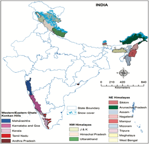
- The entire Himalayan tract, hills/ mountains in sub-Himalayan terrains of North-east India, Western Ghats, the Nilgiris in Tamil Nadu Konkan areas are landslide-prone.
RECENT LANDSLIDE DISASTERS
ü On 26th July, nine people lost their lives when a landslide suddenly flung boulders down a hill in Himachal Pradesh’s Kinnaur district.
ü On 18th July 18, a series of landslides in two areas of Mumbai claimed at least 32 lives.
ü On 14th July, five died in HP’s Kangra district after heavy rainfall triggered floods and landslides.
IMPORTANT FACTS RELATED TO LANDSLIDE RISK IN INDIA
- India has mountainous and hilly areas in as many as 16 states and two UTs, located in the Himalayan and sub-Himalayan region and the Western Ghats.
- The area prone to landslides accounts for about 12.6% of the Indian landmass, translating into 4.2 lakh square kilometers in absolute terms.
- This area spans across more than 170 districts.
- India accounts for about 18 percent of the total global fatalities due to landslides in the hills. Uttarakhand, Himachal Pradesh, J&K, and Ladakh record more than 65 percent of the landslides in the country, followed by the Northeast Himalayas and the Western Ghats.
WHY DO THE HIMALAYAS EXPERIENCE MORE LANDSLIDES THAN THE WESTERN GHATS?
- The Himalayas are one of the youngest fold mountains of the world. They are formed by the convergent movement of the Indian plate and Eurasian plate rather they are still rising in height. These tectonic movements cause frequent earthquakes in the region often resulting in landslides. Whereas the Western Ghats lies in the stable Deccan shieldless prone to landslides than the Himalayas.
- The Himalayas are greater in height than the Western Ghats. The slopes are comparatively steeper which increases the chance of landslide. Whereas the Western Ghats is much lesser in height than the Himalayas.
- The perennial rivers in the Himalayas carry a huge amount of silt and debris. The melting of glaciers even increasing the flow of water during summer thus leading to more amount of landslides. But the Western Ghats on the other hand does not face such a situation.
MAJOR LANDSLIDE PRONE AREAS OF INDIA
ANALYSING THE REASONS BEHIND LANDSLIDE
HUMAN INTERVENTION
- Human activity such as the construction of roads, buildings, and railways, mining and quarrying, and hydropower projects damage hilly slopes and impact natural drainage by removing soil and vegetation, loosening soil and gravel, and making the hills more susceptible to landslides.
- India accounted for 28% of construction-triggered landslide events, followed by China (9%), and Pakistan (6%).
- India also accounted for maximum landslides triggered by mining, at 12%, followed by Indonesia (11.7%), and China (10%).
- Bootstrapping an incompatible model of development in the hills, represented by big hydroelectric projects and large-scale construction activity involving the destruction of forests and damming of rivers, is an invitation to disasters like landslides.
- According to the GSI report, infrastructural development for tourism that involved the modification of slopes – construction of new roads and widening of existing ones, building houses, hotels, and homestays – increased the vulnerability of mountains in both the Himalayas and the Western Ghats to the rain and made the landslides and floods that much more devastating. For example, landslides in Kodagu.
- In the Western Ghats, Plantations are also the major reason for landslides. Imported tree species cannot withstand the local weather conditions and get uprooted even in a slight downpour. For example, Nilgiris initially had a lot of native trees and millet species but monoculture transformed the soil. With the use of pesticides, chemical fertilizers, and repeat planting methods, the texture of the soil changed gradually.
UNPLANNED DEVELOPMENT, FLAWED REGULATIONS
- A study analyzing building regulations in eight towns in the Himalayan region found that building bylaws do not make provisions for the particular geo-environmental context of a settlement. The same land use regulations apply regardless of topographical location, slope angle and direction, and the hazard potential of a site.
- The National Landslide Risk Management Strategy published by the NIDM in September 2019 also flagged this anomaly. The regulations are mostly inspired by Delhi Master Plan(s).
- Lack of local land use planning or its updation in the urban local bodies of the Himalayan region and the Western Ghats is resulting in ill-conceived planning, unplanned development, and ultimately slope instability.
EXTREME WEATHER
- Severe, unpredictable weather events such as heavy, intense rainfall due to the climate crisis are adding another layer of complexity to landslide incidents in the country.
- Of the total landslides triggered by rainfall, 16% were reported from India. Of these, 77% occurred during the monsoon.
NDMA’S GUIDELINES FOR LANDSLIDE AND SNOW AVALANCHES DISASTER MANAGEMENT (2009) AND NATIONAL LANDSLIDE RISK
MANAGEMENT STRATEGY (2019)
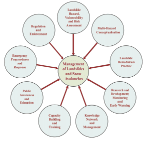
LANDSLIDE HAZARD, VULNERABILITY, AND RISK ASSESSMENT
- It includes delineating areas susceptible to landslide hazards and the status of landslide hazards in different areas and to assess the resources at risk due to these hazards as per the requirement of communities and for planning and decision-making purposes.
- This also involves site-specific studies of landslides and preparation of landslide inventory.
MULTI-HAZARD CONCEPTUALISATION
- Integrating landslide concerns into multi-hazard disaster management plans at different levels for effective risk assessment, mitigation and response.
LANDSLIDE REMEDIATION PRACTICE
- Encouraging implementation of successful landslide remediation and mitigation technologies, and execution of pacesetter examples in mitigation and remediation strategies to build confidence amongst the affected communities.
RESEARCH AND DEVELOPMENT; MONITORING AND EARLY WARNING
- Research is of critical importance in managing landslides. Developing a predictive understanding of landslide processes and triggering mechanisms; regional real-time landslide warning systems based on threshold values of rainfall; real-time monitoring and establishing early warning systems are some of the important fields of research that need immediate attention.
KNOWLEDGE NETWORK AND MANAGEMENT
- Establishing an effective system for gathering information on landslides, loss assessment resulting from landslides, and the effective dissemination of technical information and maps is an essential component of the disaster management process.
PUBLIC AWARENESS AND EDUCATION
- Effective communication of landslide hazard issues to the affected communities through education, public awareness programmes, posters, audio-visual aids, media campaigns, etc., is required.
EMERGENCY PREPAREDNESS AND RESPONSE
- Development of coordinated landslide rapid response capability involving scientists, engineers, local authorities, the National Disaster Response Force, and paramilitary forces. Rescue, relief, and rehabilitation are covered in this component.
WAY FORWARD: LANDSLIDE-PRONE AREAS NEED TECH SUPPORT
HOW MAPPING LANDSLIDES CAN MINIMISE DAMAGE
- Improvement in early warning systems, monitoring, and susceptibility zoning can reduce the damage caused by landslides.
- The Geological Survey of India (GSI) has done a national landslide susceptibility mapping at 1:50,000 scale for 85% of the entire 420,000 square km landslide-prone area in the country.
- This would not only help avoid many new landslides that are caused heavily by human interventions but also reduce damages to life and property if an incident happens.
- The maps need to be localized to give a more magnified view of the locality to be more useful. This would help to build plans and local construction activities.
PLANNING AHEAD
- Aizawl Municipal Corporation (AMC) has developed a landslide action plan using 1:5,000 scale susceptibility maps and new regulations to guide construction activities.
- It has set up a landslide policy committee involving stakeholders from various departments and researchers to prepare a long-term safety plan.
- After years of facing tragedies, Kerala is also trying to ensure disaster-resilient development in its hilly regions. The ‘Rebuild Kerala’ action plan has given high priority to the preparation of landslide hazard zonation maps in hilly areas at the municipality and panchayat levels.
- NHAI while building roads took remedial measures such as concreting with wire mesh and rock bolting, use of rockfall nets, concrete cladding, and proper diversion of surface runoff through catch drains, chutes and toe drains on berms, etc. It provides stability to the slopes.
MONITORING FOR EARLY WARNING
- Local geographical indicators offer warning signs for landslides.
- New cracks, unusual bulges and depressions in the ground; tilting trees, telecom poles or retaining walls; soil moving away from foundations; and sudden increase in water flow in streams with more mud, or decrease in flow when it is still raining or rainfall has recently stopped, can signal landslides.
- Rainfall is a key indicator. The GSI started an experiment in Landslide Early Warning System (LEWS) in Darjeeling (West Bengal) and the Nilgiris (Tamil Nadu), which could be expanded to other landslide-prone states if it proves successful. The model is based on rainfall threshold, which is the amount of rainfall a slope can hold before a landslide gets triggered, which is estimated using past cumulative rainfall data combined with landslide susceptibility data.
- Some experiments are also going on to monitor landslides through movement sensors and rain gauges. These systems alert the officials and scientists through SMS or emails once a threshold value is reached. Coimbatore-based Amrita Vishwa Vidyapeetham, for instance, has set up real-time landslide monitoring and early warning systems in Munnar (Kerala) and Gangtok (Sikkim).
- The Indian Institute of Technology (IIT), Mandi, has also installed surface-level motion-sensor-based early warning systems in Himachal Pradesh and Uttarakhand. The device collects weather parameters, soil moisture, soil movement, and rainfall intensities. When the device detects a significant displacement of the earth which could result in a landslide, it alerts the officials.
SWISS MODEL
- Prof.Madhav Gadgil who headed the Western Ghats Ecology Expert Panel (WGEEP) suggested ‘Swiss Model’ is the solution to prevent landslides in the Western Ghats
ü The extensive forest cover of Switzerland has developed only over the last 160 years.
ü Before that, only about 4% of that country’s lands had retained forest and there were disastrous landslides.
ü This led to a public awakening and a restoration of the tree cover.
ü This regeneration was managed by local communities, not by government departments.
ü Working together, communities of Switzerland, practicing genuine participatory democracy, have revived the country’s ecology.
CONCLUSION: There is a cost to pursuing development goals without paying attention to environmental constraints. Therefore, development goals must be pursued without breaching environmental regulations. Recent devastating landslides signal the dire need for ramping up disaster alert systems while enhancing climate change mitigation efforts.
Spread the Word