CONTEXT
The Great Nicobar Island (GNI) Project is a ₹92,000 crore “Holistic Development” plan aimed at tapping into the island’s strategic location near the Malacca Strait. While the project is a cornerstone of India’s “Act East” policy, it has become a subject of intense debate between developmental goals and ecological/tribal preservation.
The project is being developed by ANIIDCO (Andaman and Nicobar Islands Integrated Development Corporation), a central public sector undertaking under the Andaman and Nicobar Administration.
PROJECT COMPONENTS: THE FOUR PILLARS
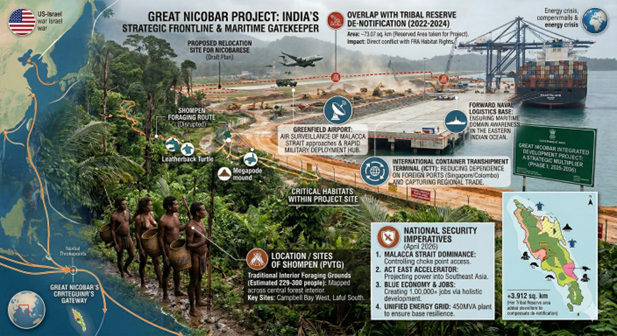
The plan covers approximately 166.10 sq. km (about 18% of the island and 2% of the total A&N landmass) and is divided into four integrated projects:
-
- International Container Transhipment Terminal (ICTT): A mega-port with a capacity of 14.2 million TEUs, positioned to compete with Singapore and Colombo.
- Greenfield International Airport: Designed for both military and civilian use, supporting long-range aircraft and tourism.
- Power Plant: A 450 MVA hybrid gas and solar-based plant to ensure energy self-sufficiency.
- Green Township: A new urban centre spanning 16,610 hectares, intended to house a population that could eventually reach several lakhs.
Tribal Safeguards & De-notification
A primary concern is the impact on the Shompen (a Particularly Vulnerable Tribal Group) and the Nicobarese. The government’s defense of the project includes:
-
- Net Addition to Reserve: While 73.07 sq. km of Tribal Reserve is being de-notified for the project, the government is re-notifying 76.98 sq. km elsewhere, resulting in a net addition of 3.912 sq. km to the reserve.
- No Displacement: The administration maintains that no tribal habitations (such as New Chingen or Rajiv Nagar) will be displaced.
- Consultation: The plan is cited as being in sync with the Shompen Policy (2015), with the Anthropological Survey of India acting as a consultant for welfare.
Environmental Mitigation & “Green” Strategy
The project involves the diversion of 130.75 sq. km of forest land. To mitigate this, the following measures are being highlighted:
-
- Compensatory Afforestation (CA): Since A&N has over 75% forest cover and lacks available land, the CA is being carried out in Haryana. Specifically, 97.30 sq. km of land in Haryana has been identified to offset Phase I.
- Tree Felling Limits: While 130.75 sq. km is being diverted, the government claims only about 7.11 lakh trees will be felled in the actual construction zones, while 65.99 sq. km will be retained as a “green area” within the project site.
- Financial Commitment: ₹81.55 crore has been released for wildlife conservation plans even before the start of construction.
Timeline: A Phased Approach
The project is designed to span over two decades to allow for gradual ecological and social monitoring:
| Phase | Duration | Area Covered |
|---|---|---|
| Phase I | 2025 – 2035 | 72.12 sq. km |
| Phase II | 2036 – 2041 | 45.27 sq. km |
| Phase III | 2042 – 2047 | 48.71 sq. km |
The strategic importance
The strategic and economic importance of the Great Nicobar Island (GNI) Project cannot be overstated. Positioned at the literal “mouth” of the Malacca Strait, it is designed to shift India from a coastal observer to a central controller of Indo-Pacific trade and security.
Geostrategic “Checkmate”: Addressing the Malacca Dilemma
Great Nicobar sits just 40 nautical miles from the Malacca Strait, a narrow chokepoint through which nearly 25–30% of global seaborne trade and a massive share of China’s energy imports pass.
-
- Maritime Domain Awareness: The project provides India with a permanent “forward base” to monitor naval movements and merchant shipping in the Six-Degree Channel.
- Countering the “String of Pearls”: It serves as a direct strategic counterweight to China’s expanding footprint in the Indian Ocean, specifically its activities in the Coco Islands (Myanmar) and Hambantota (Sri Lanka).
- First Line of Defense: By upgrading the Andaman and Nicobar Command (ANC)—India’s only tri-service command—the project enables swifter deployment of warships and aircraft, turning a remote outpost into a springboard for power projection.
Economic Sovereignty: Reclaiming Transhipment Revenue
Currently, nearly 75% of India’s transhipped cargo is handled at foreign ports like Colombo (Sri Lanka), Singapore, and Port Klang (Malaysia).
-
- Reducing Dependence: The International Container Transhipment Terminal (ICTT) at Galathea Bay will allow ultra-large container vessels to dock directly on Indian soil.
- Natural Advantage: Galathea Bay has a natural depth of over 20 meters, allowing it to host the world’s largest ships without the massive, recurring costs of dredging that other Indian ports face.
The “Act East” Springboard
The project is the physical manifestation of India’s Act East Policy, moving beyond diplomatic engagement to hard infrastructure.
-
- Regional Connectivity: The Greenfield International Airport is designed for “dual-use” (civil and military). It will not only support rapid troop movement but also open Great Nicobar to high-end eco-tourism and international business, similar to Singapore or Hong Kong.
- ASEAN Integration: Located only 80 nautical miles from Indonesia, the project facilitates closer maritime and economic coordination with Southeast Asian partners.
Energy Security and Holistic Growth
-
- Self-Sustaining Power: The 450 MVA gas and solar plant ensures that the island is not dependent on mainland supply or vulnerable diesel generators, making the military and commercial hubs resilient during crises.
- Blue Economy: The township and industrial zones are expected to generate thousands of jobs in maritime services, ship repair, and logistics, diversifying India’s “Blue Economy” portfolio.
| Category | Key Benefit |
|---|---|
| Defense | Dominance over the Six-Degree Channel and Malacca approaches. |
| Logistics | Capture of regional transhipment trade currently held by Singapore/Colombo. |
| Diplomacy | Stronger physical presence in the Indo-Pacific theatre. |
| Economy | Estimated investment of ₹72,000+ crore creating a new maritime engine. |
While the environmental costs are debated, the government views the project as a non-negotiable asset for India to achieve its “Amrit Kaal 2047” vision of becoming a global maritime power-a “Future Hong Kong” in the middle of a biosphere reserve.
CRITICAL SCRUTINY AND COUNTER-ARGUMENTS
Tribal Rights and Issues: The Challenge of “Non-Interference”
The project area is home to the Shompen (a Particularly Vulnerable Tribal Group or PVTG) and the Southern Nicobarese.
-
- The “Buffer Zone” Dilemma:While the government states that no tribal habitations will be displaced, the project involves de-notifying 07 sq. km of Tribal Reserve. Even if re-notified elsewhere, the physical presence of a mega-city, international airport, and 1.6 lakh settlers (projected) will inevitably end the “isolation” that is central to the Shompen way of life.
- The Shompen Policy vs. Reality:The 2015 Shompen Policy mandates “prioritization of their integrity.” Critics argue that a transhipment hub bringing in thousands of laborers and tourists makes “controlled contact” impossible, risking the introduction of diseases to which the tribe has no immunity.
- Consultation Gaps:The National Commission for Scheduled Tribes (NCST) and various anthropologists have pointed out that “consultation” with tribal experts is not the same as obtaining Free, Prior, and Informed Consent (FPIC) from the tribes themselves, who have no formal representation in the decision-making process.
Ecological Threats: Tropical Rainforests vs. Infrastructure
Great Nicobar is a UNESCO Biosphere Reserve and one of the most biodiverse spots on the planet.
-
- The Afforestation Paradox:The plan to cut 75 sq. km of pristine, multi-canopy tropical rainforest and “compensate” for it by planting trees in Haryana is scientifically criticized. A semi-arid plantation in Northern India cannot replicate the carbon sequestration, humidity regulation, or complex biodiversity of an equatorial rainforest.
- Species at the Brink:
- Leatherback Sea Turtles:Galathea Bay is one of the few remaining massive nesting sites for these giants. The noise, light pollution, and dredging for the ICTT could permanently disrupt their nesting cycles.
- Nicobar Megapode:This unique mound-building bird lives specifically in the coastal forests now marked for the airport and township.
- Tectonic Instability:The island is located in Seismic Zone V. The 2004 Tsunami caused the island to subside (sink) by nearly 3 meters in some areas. Building a multi-billion dollar concrete port on such a volatile tectonic plate is seen by some geologists as an ecological and financial gamble.
- The “Haryana” Afforestation Logic:Environmentalists argue that planting trees in the semi-arid ecosystem of Haryana cannot replace the tropical evergreen rainforests of the Nicobar Islands, which host unique biodiversity.
Viability of the Project: Economic Dreams vs. Regional Competition
-
- Competition with Established Hubs:The ICTT must compete with Singapore, Colombo, and Port Klang. These ports have centuries of established shipping routes, sophisticated feeder networks, and lower operating costs. Luring global shipping giants to a new, remote Indian outpost will require massive subsidies or significantly lower port tariffs.
- The “Transhipment” Trap:Transhipment is a low-margin, high-volume business. To be viable, the GNI project needs a massive influx of “feeder” ships from the Indian mainland and Southeast Asia. Without a highly efficient industrial ecosystem on the island itself, the port risks becoming an “underutilized asset.”
- Case study: Despite heavy investment, Indian terminals continue to levy significantly higher port-calling and handling costs. The experience at Krishnapatnam Port (Nellore, Andhra Pradesh) — a full withdrawal of container services in 2024, and a strategic reorientation to bulk-cargo — powerfully illustrates how cost structures and network integration continue to shape liner decisions.
- Cost Overruns and Climate Change:Given the remote location, all construction material must be shipped in, likely leading to significant cost escalations. Furthermore, Sea Level Rise projected for the 2040s (when Phase III is supposed to end) could threaten the very coastal infrastructure being built today.
| Aspect | Government Stand | Critical Concern |
|---|---|---|
| Tribal Rights | Net addition to reserve area; no displacement. | Loss of ancestral foraging grounds; risk of "contact-borne" diseases. |
| Ecology | Compensatory afforestation in Haryana; ₹81cr for wildlife. | Tropical ecosystems are irreplaceable; threat to Leatherback turtle nesting. |
| Viability | Strategic control of Malacca Strait; captures lost port revenue. | High seismic risk; intense competition from Singapore/Colombo. |
The GNI Project is a classic example of the “Development vs. Conservation” dilemma. While it offers a massive strategic advantage for India’s navy and economy, it permanently alters one of the world’s last pristine island ecosystems.
Spread the Word