THE CONTEXT: Recently, torrential rains that took place in Hyderabad have caused massive urban floods. In many Indian cities, the urban floods have become a frequent phenomenon in recent years.The scale of destruction has been unprecedented. This experience is not unique to the city of Hyderabad but something that cities across India have been experiencing in recent years. This article discusses about the urban flooding, causes, impacts and the possible solutions.
WHAT IS URBAN FLOODING?
Flooding in urban areas can be caused by flash floods, or coastal floods, or river floods, but there is also a specific flood type that is called urban flooding. It is different from normal floods, because
- Urban flooding is specific in the fact that the cause is a lack of drainage in an urban area. As there is little open soil that can be used for water storage nearly all the precipitation needs to be transport to surface water or the sewage system.
- High intensity rainfall can cause flooding when the city sewage system and draining canals do not have the necessary capacity to drain away the amounts of rain that are falling.
- Overburdened drainage, frenzied and unregulated construction, no regard to the natural topography and hydro-geomorphology all make urban floods a man-made disaster.
CAUSES
Natural causes
- Meteorological Factors- Heavy rainfall, cyclonic storms and thunderstorms causes water to flow quickly through paved urban areas and impound in low lying areas.
- Hydrological Factors- Overbank flow channel networks, occurrence of high tides impeding the drainage in coastal cities.
- Climate Change- Climate change due to various anthropogenic events has led to extreme weather events.
The rainfall received in Hyderabad in 2020 has been the highest for the month of October in a century.
Anthropological causes
- Unplanned Urbanization is the key cause of urban flooding. A major concern is blocking of natural drainage pathways through construction activity and encroachment on catchment areas, riverbeds and lake beds.
- Destruction of lakes is a major issue in India cities. Lakes can store the excess water and regulate the flow of water.
- Pollution of natural urban water bodies and converting them for development purposes has increased risk of floods.
Poor and old drainage system
Cities like Hyderabad, Mumbai rely on a century-old drainage system, covering only a small part of the core city.
- In the last 20 years, the Indian cities have grown manifold with its original built-up area.
- As the city grew beyond its original limits, not much was done to address the absence of adequate drainage systems.
- Inability to manage the city’s drainage systems is an another cause of urban flooding.
Incremental land use change
- Neglecting issues of incremental land use change, particularly of those commons which provide us with necessary ecological support — wetlands.
- This has led to creation of urban terrain which is incapable of absorbing, holding and discharging water.
- The number of wetlands has reduced to 123 in 2018 from 644 in 1956.
- Green cover is only 9 per cent, which ideally should have been at least 33 per cent.
Overlooking environmental regulations
Overlooking environmental regulations in mega-projects is fairly common in the country.
- Commonwealth Games Village (CWG) were built right on the Yamuna’s floodplain.
- The secondary runway of Chennai International Airport was also built right over the Adyar river. Most of the airport was constructed on the riverine floodplains, leading to massive flooding during the 2015 Chennai floods.
- Recent developments such as Andhra Pradesh’s Amaravati Capital City Project, had major areas proposed to be built on the floodplains of Krishna river.
IMPACTS OF URBAN FLOODS
- Economy- Damage to infrastructure, roads and settlements, industrial production, basic supplies, post disaster rehabilitation difficulties etc.
- Human population and wildlife– Trauma, loss of life, injuries and disease outbreak, unhygienic living conditions in slums, contamination of water etc.
- Environment- Loss of habitat, tree and forest cover, biodiversity loss and large scale greenery recovery failure.
- Transport and communication– Increased traffic congestion, disruption in rail services, disruption in communication- on telephone, internet cables causing massive public inconvenience.
WHAT SHOULD BE DONE?
Holistic engagement
- Floods needs to be managed with concerted and focused investments of energy and resources.
- The Metropolitan Development Authorities, National Disaster Management Authority, State revenue and irrigation departments along with municipal corporations should be involved in such work together.
- Such investments can only be done in a mission mode organisation with active participation of civil society organisations at the metropolitan scale.
Developing Sponge Cities
- The idea of a sponge city is to make cities more permeable so as to hold and use the water which falls upon it.
- Sponge cities absorb the rain water, which is then naturally filtered by the soil and allowed to reach urban aquifers.
- This allows for the extraction of water from the ground through urban or peri-urban wells.
- This water can be treated easily and used for city water supply.
Wetland Policy
There is a need to start paying attention to the management of wetlands by involving local communities.
- Terrain alteration needs to be strictly regulated and a ban on any further alteration of terrain needs to be introduced.
- To improve the city’s capacity to absorb water, new porous materials and technologies must be encouraged or mandated across scales.
- Examples of these technologies are bio-swales and retention systems, permeable material for roads and pavement, drainage systems which allow storm water to trickle into the ground, green roofs and harvesting systems in buildings.
EIAs and enforcement will remain vital to ensure that fragile wetlands and floodplains are not concretised.
Drainage planning
- Watershed management and emergency drainage plan should be clearly enunciated in policy and law.
- Urban watersheds are micro ecological drainage systems, shaped by contours of terrain.
- Detailed documentation of these Urban watersheds must be held by agencies where natural boundaries instead of governance boundaries (like wards) are used to come up with drainage plan.
Water sensitive urban design
- Methods should be adopted which takes into consideration the topography, types of surfaces (permeable or impervious), natural drainage and leave very less impact on the environment.
- Vulnerability analyses and risk assessments should form part and parcel of city master plans.
- In a changing climate, the drainage infrastructure (especially storm water drainage) has to be built considering the new ‘normals’.
- Tools such as predictive precipitation modelling can help do that and are also able to link it with the adaptive capacity of urban land use.
These can all be delivered effectively through an urban mission along the lines of the Atal Mission for Rejuvenation and Urban Transformation (AMRUT), National Heritage City Development and Augmentation Yojana (HRIDAY) and Smart Cities Mission.
CONCLUSION: Urban Flood management will not just help control recurring floods but also respond to other fault lines, provide for water security, more green spaces, and will make the city resilient and sustainable. We need to urgently rebuild our cities such that they have the sponginess to absorb and release water without causing so much misery and so much damage to the most vulnerable of our citizens
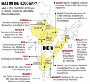
CASE STUDIES OF URBAN FLOODING
1. HYDERABAD FLOODS
Urban flooding has become a common occurrence these days in India. The latest victim of urban flooding is Hyderabad.
Basic information-The city as well Telangana received unusually excessive rainfall October 13-14, 2020, due to a deep depression that developed in the Bay of Bengal. Heavy damage to property, roads and human lives has been reported.
The population of the city has grown exponentially. It is 10 million today.
Geographical setting- Hyderabad is located on the banks of the Musi river. The Himayat Sagar and Osman Sagar dams on the river, supply the water to the city.
Based on hydrology, present-day Hyderabad can be divided into Krishna and Godavari basins. Traditionally, all the rainwater falling in the catchment areas of Musi would discharge into Musi which is one of the 22 tributaries of the Krishna river. And newer localities to the west of Hyderabad, including Gachibowli and the IT corridor, are all in the catchment areas of the Godavari.In both Krishna and Godavari basins, the city has a network of lakes and drains which carry the excess water from one to another and then finally into the Musi and Majeera rivers.
Over the years, owing to the expansion of the city, the lakes were not in demand for their primary purposes of irrigation and drinking water. But they continued to be relevant for flood regulation.
Issue-The city of Hyderabad doesn’t usually get flooded due to monsoonal rain, which is spread over a long period. There is a natural system of flow of water from a high elevated area to a lower one. But Lakes in the town have shrunk due to encroachment. Discharge of sewage and industrial effluents, encroachments by government and private individuals, and decades of neglect had everyone thinking the river would never flow again. Most of the former waterways are open sewers now. But, on October 13, the river was in spate once again after a record downpour. Low-lying localities and colonies that were built on the lake beds and nullahs were submerged in no time. Many days later, hundreds of these colonies were still under water.
Large water bodies that existed for centuries have shrunk in size, encroachments have eaten into natural waterways, and stormwater drains get easily clogged.
Losses-As many as 33 lives have been lost to heavy rains and floods in the city, with the GHMC estimating that at least 37,409 families have been affected. The Municipal Administration minister pegged the city’s losses at Rs 670 crore.
2. MUMBAI FLOODS
Basic information-The 2005 Maharashtra floods impacted many parts of the Indian state of Maharashtra including large areas of the metropolis Mumbai, a city located on the coast of the Arabian Sea, on the Western coast of India. The floods were caused by the eighth heaviest-ever recorded 24-hour rainfall figure of 944 mm (37.17 inches) which lashed the metropolis on 26 July 2005, and intermittently continued for the next day.
Approximately 1,094 people died and city of Mumbai came to a standstill due to flooding.
Issues
- The present storm-water drainage system in Mumbai was put in place in the early 20th century and is capable of carrying only 25.1237 millimetres of water per hour which was extremely inadequate on a day when 993 mm of rain fell in the city. The drainage system was also clogged at several places.
- Haphazard Development- Development in certain parts of Mumbai is haphazard and buildings are constructed without proper planning. The drainage plans in northern suburbs is chalked out as and when required in a particular area and not from an overall point of view.
- Destruction of mangrove ecosystems- Mangrove ecosystems which exist along the Mithi River and Mahim Creek are being destroyed and replaced with construction. These ecosystems serve as a buffer between land and sea.
- Sewage and garbage dumps have also destroyed mangroves. The Bandra-Kurla complex in particular was created by replacing such swamps. The most acclaimed Mindspace CBD (INORBIT MALL) in Goregaon & Malad has been built by destroying a large patch of mangroves in Maharashtra.
3. CHENNAI FLOODS
Basic information-Chennai received 1,049 mm (41.3 in) of rainfall in November, the highest recorded since November 1918 when 1,088 mm (42.8 in) in of rainfall was recorded. On 1 December, heavy rains led to inundation in many areas of Chennai.
Chennai is built on flat coastal floodplains. Wetlands – including natural and artificial drains are the city’s insurance against heavy rains and cyclonic storm surges.
Issues-A study revealed how the city’s built-up area grew nine-fold – from 47 sq km in 1980 to 402 sq km in 2012 – even while area under wetlands declined from 186 sq km to 71 sq km during the same period. Between 1996 and 2015, more than 1,000 acres of this wetland was allegedly illegally diverted to accommodate industrial installations belonging to state-owned companies, including a large port and several coal-fired power plants.
The 2015 rains crippled the neighbourhoods drained by the creek. Some went under because power plants, coal ash ponds and coal yards blocked the flowing run-off from their habitations to the creek. Others were harmed by waters backing up far inland because their natural holding area – the backwaters – had been eaten into. The floods brought the refinery to a halt.
A parliamentary committee that enquired into the cause of the 2015 floods was categorical in its report that “encroachment of lakes and riverbeds played a major role in causing massive floods in Chennai”.
Impact-Power supplies were suspended to 60% of the city while several city hospitals stopped functioning. The Southern Railways cancelled major train services and Chennai International Airport was closed until 6 December.