Introduction: Jammu and Kashmir’s difficult Himalayan terrain is being overcome through a wave of rail, road, tunnel and airport projects. Jammu & Kashmir’s difficult Himalayan terrain has historically constrained all-weather connectivity, market access and economic integration. Recent investments in railways, roads, tunnels, airports and multimodal logistics are gradually changing this geography of isolation.
Why is Jammu and Kashmir Important for India?
-
- Strategic and border location: J&K borders Pakistan (Line of Control) and through Ladakh, China (Line of Actual Control). It also includes high-altitude areas such as Siachen which is critical for defence logistics and border security.
- Geopolitical gateway: Lies at the junction of South, Central and West Asia near the Wakhan corridor to Afghanistan. Its stability shapes India’s regional influence.
- Constitutional and political significance: Acceded to India in 1947 (Instrument of Accession), Article 370 was abrogated on 5 August 2019 and J&K Reorganisation Act, 2019 created the UTs of J&K and Ladakh. India’s position, reiterated in the 1994 Parliament resolution is that all of J&K, including PoK and Aksai Chin is an integral part of India.
- Water and energy: The Indus system rivers (Indus, Jhelum, Chenab) flow through J&K, with large hydropower potential (Salal, Baglihar, Pakal Dul, Kiru, Ratle and others). Indus Waters Treaty (1960) is a major issue in India–Pakistan relations.
- Economy: Horticulture (apples, dry fruits), saffron (GI-tagged), pashmina and handicrafts and tourism and pilgrimage (Amarnath, Vaishno Devi, Gulmarg, Sonamarg).
Pakistani and Chinese Developments in PoK and Aksai Chin
India regards Pakistan-occupied Kashmir (PoK) and Gilgit-Baltistan and Aksai Chin as illegally occupied parts of J&K and Ladakh. Infrastructure built there by Pakistan and China has strategic, legal and diplomatic implications for India.
A. PoK and Gilgit-Baltistan (Pakistan with Chinese support)
1. China–Pakistan Economic Corridor (CPEC): Flagship of China’s Belt and Road Initiative, launched in 2015. Its road and energy projects pass through Gilgit-Baltistan and PoK. India objects on sovereignty grounds and has not joined BRI.
2. Karakoram Highway (KKH): Built by China and Pakistan (opened in the late 1970s) linking Xinjiang to Pakistan through Gilgit-Baltistan which has been upgraded under CPEC.
3. Hydropower and dams: Chinese-built or financed projects such as Neelum–Jhelum (PoK), Kohala and Diamer-Bhasha Dam (Gilgit-Baltistan). India has protested against projects in disputed territory.
4. Shaksgam Valley: Under the 1963 China–Pakistan boundary agreement, Pakistan ceded the Shaksgam area to China which India rejects as illegal. China has built roads in the area.
5. Concerns: Chinese presence in PoK, debt dependence of Pakistan, strategic encirclement, and local discontent over resources and governance (for example protests in PoK in 2024).
B. Aksai Chin (under Chinese control)
1. Area and history: About 38,000 sq km of Ladakh under Chinese control since the 1950s; China built the Xinjiang–Tibet (G219) highway through it (late 1950s), which was a trigger for the 1962 India–China War.
2. Connectivity: Roads and rail plans linking Xinjiang and Tibet (G219, and the planned Hotan–Shigatse railway), forward airbases, border villages (“Xiaokang”) and military infrastructure along the LAC; a bridge across Pangong Tso was built (reported 2022).
3. Implications: Better Chinese logistics reduces reaction time and strengthens military posture in Eastern Ladakh, as seen in the 2020 standoff.
| Aspect | Pakistan / China Side | Indian Side (J&K and Ladakh) |
|---|---|---|
| Road and rail | KKH, G219, planned Hotan–Shigatse railway. | USBRL, DS-DBO road, Zojila and Sonamarg tunnels, Atal Tunnel. |
| Energy | CPEC and Chinese-financed hydropower in PoK/GB. | Chenab valley hydropower and a Ladakh–Haryana green energy corridor. |
| Border areas | Xiaokang villages and military infrastructure. | Vibrant Villages Programme, Project Beacon (e.g., NH-701 corridor). |
| Legal position | Projects in disputed territory, opposed by India. | Infrastructure in India’s sovereign territory. |
Infrastructure development in J&K
1. Railways
i. Udhampur–Srinagar–Baramulla Rail Link (USBRL)
-
-
-
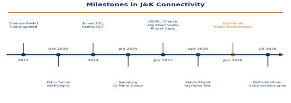
- Inaugurated June 2025; cost ₹43,780 crore; covers Udhampur, Reasi, Ramban, Srinagar, Anantnag, Pulwama, Budgam and Baramulla.
- 272 km through the Himalayas with 36 tunnels (119 km) and 943 bridges; fully electrified.
- 215+ km of roads (including a tunnel and 320 bridges) built for communities; 5 crore+ man-days of employment.
-
-
ii. Vande Bharat Express
-
-
-
- Started in June 2025 (Katra–Srinagar); extended to Jammu Tawi in April 2026; Jammu–Srinagar in under five hours.
- Trains augmented from 8 to 20 coaches, built for extreme weather and high altitude. A snow-removal train clears the track ahead & seismic dampers absorb tremors.
-
-
Supporting railway infrastructure
1. Electrification: About 6% of the BG network is electrified; entire existing BG network in J&K is electrified.
2. Amrit Bharat Station Scheme: 1,340 stations identified nationally; four in J&K (Budgam, Jammu Tawi, Udhampur, Katra).
3. Pipeline projects: Third line Jalandhar Cantt.–Jammu Tawi (216 km), additional line Jammu–Katra (78 km), new line Jammu/Reasi–Poonch (190 km) for border and strategic areas.
| Engineering Marvel | Key Features |
|---|---|
| Chenab Rail Bridge | Reasi district which was inaugurated June 2025. It is world’s highest railway arch bridge. 1,315 m long; 467 m arch span; 359 m above the riverbed (higher than the Eiffel Tower); designed for seismic and wind forces. |
| Anji Khad Bridge | India’s first cable-stayed railway bridge. 193 m single inverted ‘Y’ tower, main bridge 473.25 m; inaugurated June 2025. |
| Tunnel T50 | 12.77 km (Khari–Sumber), inaugurated 2024. India’s longest transportation tunnel; built by the New Austrian Tunnelling Method; parallel escape tunnel linked every 375 m; CCTV every 50 m. |
2. Roads and Tunnels
-
- PMGSY-IV (August 2026): Foundation stones for 110 road projects (598.455 km) costing over ₹1,500 crore, benefitting 46,972 people in the Udhampur–Kathua–Doda–Kishtwar region, with waste plastic used in several packages.
- Delhi–Amritsar–Katra Expressway: 667-km greenfield corridor; key sections inaugurated July 2026; cuts Delhi–Katra travel from ~14 hours to ~6 hours; boosts pilgrim traffic and logistics.
- Rafiabad–Kupwara road (NH-701): Widening started June 2025, part of Project Beacon, for border last-mile connectivity.
- Shopian Bypass (NH-444): ₹224.44 crore, 925 km, faster transport of agricultural produce.
| Tunnel | Key Features |
|---|---|
| Sonamarg (Z-Morh) Tunnel | Inaugurated January 2025; 6.4 km bi-directional with parallel escape tunnel; ₹2,700+ crore; altitude 2,634 m; all-weather Srinagar–Sonamarg link to Leh; avoids avalanche zones; makes Sonamarg a year-round destination. |
| Zojila Tunnel | 13.153 km, Baltal–Minamarg on NH-1, by NHIDCL; ₹6,808 crore; 2,900–3,310 m altitude; work began October 2020, main tunnel breakthrough June 2026; cuts Sonamarg–Minamarg time from about 2 hours to 30 minutes; includes ventilation, fire suppression, SCADA, CCTV and avalanche protection; boosts tourism, trade and defence logistics. |
| Dr Syama Prasad Mookerjee (Chenani–Nashri) Tunnel | Opened 2017; 9 km; India’s longest operating highway tunnel and Asia’s longest bi-directional tunnel; ₹2,500 crore; saves 31 km and 2 hours. |
3. Airports
-
- Srinagar International Airport: ₹1,677 crore civil enclave expansion approved February 2026 (operated by AAI within IAF’s Budgam airbase); 18 acres; 71,500 sq m terminal for 10 million passengers/year; 15 aircraft bays; 1,000-car parking; Kashmiri architecture and GRIHA 5-star target.
- Udhampur and Kishtwar airports planned under UDAN to extend regional connectivity, supporting tourism, jobs and investment.
From Connectivity to Economic Integration
-
- PM Gati Shakti National Master Plan (October 2021): GIS-based integration of rail, road, port, waterway, airport and logistics infrastructure (as per this PIB, 44 Central Ministries and 36 States/UTs).
- Gati Shakti Cargo Terminal (GCT) policy (December 2021): Encourages private rail-linked cargo terminals; 142 GCTs commissioned nationally; Samba (J&K) operational since 2024, in-principle approvals for 310 more locations, including Kathua, Anantnag and Jammu.
- Market access: Apples, dry fruits, pashmina and handicrafts can reach larger markets; connectivity also strengthens border security and disaster response.
Significance
-
- All-weather links to Ladakh, rail and road to border areas improve logistics, mobilisation and disaster response, countering infrastructure built across the LoC and LAC.
- Faster freight for apples, saffron and handicrafts, lower costs and investment through multimodal terminals.
- Year-round tourism (Sonamarg, winter sports, pilgrimage) and jobs (5 crore+ man-days under USBRL).
- Reduces seasonal isolation, and links the Valley, Jammu and Ladakh with the rest of India.
- Chenab, Anji Khad and T50 show indigenous capability and set standards for Himalayan infrastructure.
Challenges
i. Avalanches, landslides, seismic zone IV–V, water ingress and glacial and climate-related hazards raise costs and maintenance needs.
ii. Large projects (USBRL, Zojila) have seen long timeline. Operations in winter need continuous snow clearance.
iii. Tunnelling, road cutting and tourism growth can stress Himalayan ecology, springs and slopes.
iv. Infrastructure is a target for terrorism or sabotage, requiring strong protection and surveillance.
v. Connectivity alone does not ensure industrial growth. Cold chains, processing and market linkages are needed.
vi. China and Pakistan are also building infrastructure in PoK, Gilgit-Baltistan and Aksai Chin, which needs sustained Indian investment.
Way Forward
i. Learn from Switzerland (Gotthard Base Tunnel), Austria and Norway’s Lærdal tunnel on safe, long Alpine tunnelling, ventilation and disaster management.
ii. Complete pending projects (Zojila, rail extensions to Poonch) on time and plan rail links towards Ladakh with strategic value.
iii. Link J&K projects with PM Gati Shakti, ITLA and the National Logistics Policy for seamless multimodal planning.
iv. Build cold chains, food parks, GCTs and processing units for apples, saffron and handicrafts, with FPO and GI-based branding.
v. Strengthen disaster-resilient design, early-warning systems and eco-sensitive construction with local community involvement.
vi. Expand last-mile connectivity (PMGSY, border roads, Vibrant Villages Programme) and UDAN services for remote areas.
Conclusion
Rail, road and air projects in J&K now work as one integrated network converting a region of seasonal isolation into a connected part of India’s economic geography. Sustained, safe and eco-sensitive infrastructure, with strong market linkages and security, will strengthen economic integration, border preparedness and national unity.
Spread the Word