THE CONTEXT: Western Afghanistan experienced a magnitude 6.3 earthquake on October 15, 2023, occurring shortly after multiple earthquakes with similar magnitudes claimed the lives of at least a thousand individuals in the Herat province. The Indian subcontinent is highly vulnerable to frequent earthquakes due to several geomorphological factors. The following article attempts to assess the reasons for frequent earthquakes in the Indian sub-continent from UPSC perspective.
FREQUENT EARTHQUAKES IN AFGHANISTAN
- Afghanistan has a history of enduring extensive destruction due to powerful earthquakes. For instance, in June 2022, a magnitude 6.1 earthquake struck Khost and Paktika provinces, resulting in over 1,000 casualties. In 2015, a significant earthquake in the northeast of the country caused the deaths of more than 200 people in both Afghanistan and neighboring northern Pakistan. Additionally, a 6.1-magnitude earthquake in 2002 claimed around 1,000 lives in northern Afghanistan.
Why Afghanistan is earthquake prone?
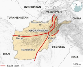
- Afghanistan, a nation bordered by mountains and known for its history of significant seismic activity, frequently witnesses strong earthquakes, particularly in the challenging Hindu Kush region near the Pakistan border.
- Afghanistan’s location is marked by the convergence of multiple fault lines, where the Indian and Eurasian tectonic plates meet and interact. This frequent collision of plates results in considerable tectonic activity in the region.
- Afghanistan is situated on the Eurasian plate. In western Afghanistan, the Arabian plate subducts northward beneath Eurasia, while in the east, the Indian plate similarly subducts under Eurasia. In southern Afghanistan, the Arabian and Indian plates meet and both subducts northward under the Eurasian plate.
- The geological complexity of the Hindu Kush Mountain range and the Pamir Knot, where these tectonic plates converge, contributes to the folding and faulting of the Earth’s crust. This geological intricacy is a significant factor behind the occurrence of earthquakes in the area.
- Moreover, the continual northward movement of the Indian Plate toward the Eurasian Plate leads to compression, resulting in the uplifting of the Himalayas and the transmission of tectonic stress across the entire region, including Afghanistan. This compression causes the Earth’s crust to deform, creating faults and fractures that can slip and generate earthquakes. The interactions at these plate boundaries generate substantial tectonic stresses, leading to seismic events.
- Afghanistan is also intersected by various active fault systems such as the Chaman Fault and the Main Pamir Thrust. These fault systems serve as sources of numerous earthquakes in the region.
UNDERSTANDING THE GENESIS OF EARTHQUAKES
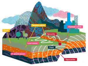
- Earthquakes are the result of sudden movement along faults within the Earth. The movement releases stored-up ‘elastic strain’ energy in
 the form of seismic waves, which propagate through the Earth and cause the ground surface to shake. Such movement on the faults is generally a response to long-term deformation and the buildup of stress.
 - Seismic waves from large earthquakes pass throughout the Earth. These waves contain vital information about the internal structure of the Earth. As seismic waves pass through the Earth, they are refracted, or bent, like rays of light bend when they pass through a glass prism.
- The Earth’s outermost layer is fragmented into about 15 major slabs called tectonic plates. These slabs form the lithosphere, which is comprised of the crust (continental and oceanic) and the upper part of the mantle. Tectonic plates move very slowly relative to each other, typically a few centimeters per year, but this still causes a huge amount of deformation at the plate boundaries, which in turn results in earthquakes.
- What drives the movement of tectonic plates?
 the form of seismic waves, which propagate through the Earth and cause the ground surface to shake. Such movement on the faults is generally a response to long-term deformation and the buildup of stress.
Below the tectonic plates lies the Earth’s asthenosphere. The asthenosphere behaves like a fluid over very long-time scale. There are a number of competing theories that attempt to explain what drives the movement of tectonic plates.
-
- Mantle convection currents: warm mantle currents drive and carry plates of lithosphere along a like a conveyor belt.
- Ridge push (buoyant upwelling mantle at mid-ocean ridges): newly formed plates at oceanic ridges are warm, so they have a higher elevation at the oceanic ridge than the colder, more dense plate material further away; gravity causes the higher plate at the ridge to push away the lithosphere that lies further from the ridge.
- Slab pull: older, colder plates sink at subduction zones because, as they cool, they become denser than the underlying mantle and the cooler, sinking plate pulls the rest of the warmer plate along behind it.
INDIA’S VULNERABILITY TOWARDS EARTHQUAKES
India is prone to earthquakes due to its geographical location and tectonic activity. India is situated on the Indian Plate, which is moving northward and colliding with the Eurasian Plate. The interaction between these two plates causes frequent earthquakes in the region. Here are some major earthquake-prone zones in India:
- Himalayan Region: The Himalayan region is one of the most seismically active zones in India. The collision between the Indian and Eurasian plates causes frequent earthquakes in this region. The Himalayan region comprises several states, including Jammu and Kashmir, Himachal Pradesh, Uttarakhand, Sikkim, and Arunachal Pradesh.
- Northeastern Region: The northeastern region of India is also seismically active due to its location on the boundary of the Indian and Eurasian plates. The region comprises states such as Assam, Manipur, Mizoram, Nagaland, Tripura, and Meghalaya.
- Central India: Central India is also prone to earthquakes, although it experiences fewer earthquakes compared to the Himalayan and northeastern regions. The region includes states such as Madhya Pradesh, Chhattisgarh, and Maharashtra.
- Western India: The western region of India is also seismically active, primarily due to its proximity to the Arabian Sea. The region includes states such as Gujarat and Rajasthan.
- Andaman and Nicobar Islands: The Andaman and Nicobar Islands are also prone to earthquakes due to their location on the boundary of the Indian and Burmese plates.
 Eurasian plates causes frequent earthquakes in this region. The Himalayan region comprises several states, including Jammu and Kashmir, Himachal Pradesh, Uttarakhand, Sikkim, and Arunachal Pradesh.
WHY INDIAN SUB-CONTINENT IS PRONE TO FREQUENT EARTHQUAKES?
Earthquakes are frequent in the Indian subcontinent region primarily due to its tectonic setting and the interactions of major geological plates. The primary reasons for the seismic activity in this region are as follows:
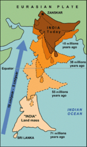
1. Plate Tectonics: The Indian subcontinent is located at the convergence of several major tectonic plates. The most significant is the collision between the Indian Plate and the Eurasian Plate. The Indian Plate is moving northward and is subducting beneath the Eurasian Plate, creating immense pressure and stress along the plate boundaries. This collision is the fundamental cause of seismic activity in the region.
- Indian Plate: The Indian Plate is a massive tectonic plate that includes the entire Indian subcontinent and extends into the Indian Ocean. It is in motion, and its primary direction of movement is northward.
- Eurasian Plate: To the north of the Indian Plate lies the Eurasian Plate, which encompasses a vast region of Europe and Asia, including most of China and Russia. This plate is significantly larger and thicker than the Indian Plate.
- Convergent Boundary: The key geological feature of the Indian subcontinent is the convergent boundary formed by the collision of the Indian Plate with the Eurasian Plate. This collision is a result of the northward movement of the Indian Plate, which is converging with the Eurasian Plate at a rate of several centimeters per year. This collision zone extends across the northern boundary of India, Nepal, Bhutan, and parts of Pakistan.
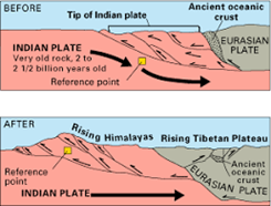
- Himalayan Mountain Building: The immense pressure and force generated by the converging Indian and Eurasian plates lead to the uplift of the Earth’s crust in the region. This results in the formation of the towering Himalayan Mountain range, which is one of the youngest and most spectacular mountain chains on Earth. The Himalayas continue to rise due to this ongoing tectonic collision.
- Seismic Activity: The interaction between these two massive plates creates tremendous stress and strain along the plate boundary. This stress is released periodically in the form of earthquakes, making the Indian subcontinent one of the most seismically active regions in the world. The seismic activity is not limited to the Himalayas but extends to other fault systems and regions throughout the subcontinent.
- Secondary Plate Boundaries: Besides the primary collision with the Eurasian Plate, the Indian Plate also interacts with other smaller tectonic plates. For example, along the western coast of India, it subducts beneath the Arabian Plate, creating additional seismic activity. In the east, it collides with the Burmese Plate, contributing to the geological complexity of the region.
 Ocean. It is in motion, and its primary direction of movement is northward.
2. Himalayan Mountain Building: The Himalayan Mountain range, which stretches across northern India, Nepal, Bhutan, and Pakistan, is the result of the ongoing collision between the Indian Plate and the Eurasian Plate. The slow but forceful convergence of these plates causes the Earth’s crust to crumple and uplift, resulting in frequent seismic events.
- Subduction and Collision: The Indian Plate is denser than the Eurasian Plate, so it subducts beneath the Eurasian Plate. However, unlike traditional subduction zones where one plate sinks beneath another, in the Himalayan region, the Indian Plate is not subducting very deeply.
- Crustal Uplift: Over millions of years, the Indian Plate has crumpled and buckled the Eurasian Plate, leading to the creation of the towering peaks and deep valleys that characterize the Himalayas.
- Folded Mountains: The Himalayas are an excellent example of folded mountains. The intense pressure and heat generated by the colliding plates cause the rocks and sediments in the region to fold, creating anticlines and synclines and are responsible for the distinctive geological features of the Himalayas.
- Faulting and Earthquakes: The Indian subcontinent is one of the most seismically active regions in the world due to the constant release of accumulated stress along fault lines.
- Continued Uplift and Erosion: The Himalayan mountain-building process is ongoing. Simultaneously, erosion, driven by the monsoon rains and glacial processes, is continually wearing down the mountains.
 release of accumulated stress along fault lines.
3. Complex Fault Systems: The Indian subcontinent is indeed characterized by numerous fault systems and zones, both on-land and offshore, that contribute to the frequent occurrence of earthquakes in the region. The movement along these fault systems and their interactions contribute to the seismic activity in the region.
- Main Himalayan Thrust (MHT) Fault: The Main Himalayan Thrust marks the boundary between the Indian Plate and the Eurasian Plate, creating immense stress and strain. The release of this stress results in major earthquakes, often with devastating consequences.
- Central Seismic Gap: The Central Seismic Gap is a segment of the MHT Fault that has not experienced a major earthquake for a prolonged period, holding possibility that the accumulated strain may be released in a future event.
- North Anatolian Fault: The North Anatolian Fault is another significant fault system that affects the western part of the Indian subcontinent. This transform fault is located in Turkey and extends into the eastern Mediterranean.
- Indo-Burmese Arc: Off the eastern coast of India, the Indo-Burmese Arc is a complex tectonic boundary where the Indian Plate collides with the Burmese Plate. This region is prone to seismic activity, and earthquakes here can have implications for areas along the eastern coast of India and Bangladesh.
- Kachchh Rift Basin: In the western part of India, the Kachchh Rift Basin is characterized by several active fault systems. The 2001 Bhuj earthquake, with a magnitude of 7.7, occurred in this region, causing significant damage.
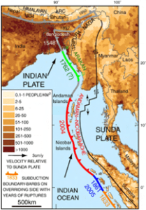
- Andaman-Sumatra Subduction Zone: In the Indian Ocean, the Andaman-Sumatra Subduction Zone is a major tectonic boundary where the Indian Plate is subducting beneath the Burmese Plate and the Sunda Plate. This subduction zone has been responsible for several major tsunamigenic earthquakes, including the 2004 Indian Ocean tsunami.
 prolonged period, holding possibility that the accumulated strain may be released in a future event.
4. Subduction Zones and Plate Boundaries: The Indian subcontinent is marked by several subduction zones and plate boundaries that significantly contribute to the occurrence of earthquakes. These tectonic features are a result of the interactions of the Indian Plate with neighboring plates and play a crucial role in shaping the seismic activity in the region.
- Himalayan Collision Zone: The Himalayan Mountain range while not a subduction zone in the traditional sense, the intense tectonic pressure at this convergent boundary results in frequent seismic activity, including powerful earthquakes.
- Makran Subduction Zone: Along the southwestern coast of Pakistan and southeastern Iran, the Indian Plate is subducting beneath the Eurasian Plate along the Makran Subduction Zone and is a potential source of tsunamigenic earthquakes in the northern Arabian Sea.
- Burma Plate Boundary: In the eastern part of the Indian subcontinent, the Indian Plate interacts with the Burmese Plate, forming the Indo-Burmese Arc. The associated stress and strain along this boundary lead to earthquakes, with potential implications for northeastern India and Bangladesh.
- Western and Eastern Continental Margins: Along the western and eastern coasts of India, there are continental margins where the Indian Plate interacts with the Arabian Plate and the Eurasian Plate, respectively. These interactions can lead to strike-slip and thrust faulting, causing seismic events. The 2001 Bhuj earthquake in Gujarat, for example, occurred along the western margin.
- Carlsberg Ridge: The Carlsberg Ridge, located in the western Indian Ocean, is a mid-ocean ridge where the Indian Plate is diverging from the African Plate. The movement along this divergent boundary can also generate seismic activity.
WHY DELHI-NCR IS FACING BACK-TO-BACK EARTHQUAKES?
- Delhi is positioned on several active seismic fault lines, including the Sohna fault line, the Mathura fault line, and the Delhi-Moradabad fault line. In contrast, Gurgaon, within the Delhi-National Capital Region, is situated on no fewer than seven fault lines, making it particularly vulnerable to seismic activity.
- Delhi has a historical susceptibility to earthquakes because it falls within the fourth-highest seismic zone out of the five designated by the Bureau of Indian Standards. Despite this, it’s worth noting that Delhi has never served as the epicenter of any earthquake thus far, and such an occurrence is unlikely in the foreseeable future.
INDIA’S PREPAREDNESS FOR EARTHQUAKES
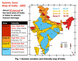
Nearly 58 per cent of the Indian landmass is vulnerable to earthquakes and the concerns that have been raised by the court need a policy response. The Indian government has taken several steps to tackle earthquakes in India. Here are some of the steps taken by the government for tackling earthquakes in India:
- Building Codes and Guidelines: The Bureau of Indian Standards (BIS) has developed codes and guidelines for earthquake-resistant construction in India. These codes and guidelines provide a framework for safe and earthquake-resistant building design and construction.
- Disaster Management Plans: The National Disaster Management Authority (NDMA) has developed disaster management plans to tackle earthquakes in India. The plans include measures for early warning systems, search and rescue operations, medical aid, and relief and rehabilitation efforts.
- Public Awareness Campaigns: The government has launched several public awareness campaigns to educate people about earthquake safety and preparedness. The campaigns include disseminating information on earthquake-resistant construction, emergency preparedness, and evacuation procedures.
- Seismic Monitoring: The government has established a network of seismic monitoring stations across the country to monitor seismic activity and provide early warning systems. The Indian Meteorological Department (IMD) operates these monitoring stations.
- Research and Development: The government has invested in research and development to improve earthquake-resistant construction techniques and materials. The Central Building Research Institute (CBRI) and the National Institute of Disaster Management (NIDM) are some of the institutions working on earthquake-related research and development.
- International Collaboration: The Indian government has collaborated with international organizations, including the United Nations Development Programme (UNDP), to improve earthquake preparedness and response in the country.
CHALLENGES IN INDIA’S EARTHQUAKE PREPAREDNESS
- Issues with National Building Code: National Building Code ignores the buildings that were constructed before such codes were published in 1962. Such buildings form a large part of our cities. Further, it assumes infallibility in the processes of enforcement relying only on penalization and illegalities. It treats earthquakes as a problem of individual buildings as if they exist and behave in complete isolation from their urban context. Although India has building codes that incorporate seismic provisions, their consistent implementation remains a challenge, particularly in smaller towns and rural areas. This results in the construction of non-engineered or poorly engineered buildings.
- Population Density: India is one of the most densely populated countries in the world, and this poses a significant challenge for earthquake management. The high population density makes it difficult to evacuate people in the event of an earthquake, and it also puts a strain on relief and rehabilitation efforts. Also, India’s rapid urbanization has led to the growth of informal settlements and slums in seismically vulnerable areas, where substandard construction practices are common.
- Informal Construction: A significant percentage of buildings in India are constructed informally, without following proper building codes and guidelines. These buildings are often vulnerable to earthquakes and can cause significant damage and casualties.
- Limited Resources: India is a developing country, and it often lacks the resources and infrastructure required for effective earthquake management. This includes inadequate funding for research and development, limited equipment and resources for search and rescue operations, and insufficient medical facilities for emergency treatment.
- Geological Diversity: India has a diverse geological makeup, which makes it challenging to predict earthquake activity accurately. Different regions in the country have different seismic histories, and this requires tailored earthquake management strategies.
THE WAY FORWARD
- Retrofitting Buildings to Seismic Codes:
- Aim: To create a system of tax-based or development rights-based incentives for retrofitting one’s building up to seismic codes.
- Such a system of incentives will enable the growth of an industry around retrofitting and will generate a body of well-trained professionals and competent organisations.
- Better enforcement of seismic codes:
- Ensuring better enforcement of seismic codes through step such as the National Retrofitting Programme launched in 2014.
- Under the programme, the Reserve Bank of India directed banks to deny loans for any building activity that does not meet the standards of earthquake-resistant design.
- Care contemplation of construction projects:
- For example, experts from different organisations including the Geological Survey of India, IIT Roorkee, are studying the cause of the sinking, and many geologists have blamed NTPC’s Tapovan-Vishnugad hydroelectric power project for the current disaster.
- Strict policy formulation:
- After the 2001 Bhuj earthquake, the Gujarat government immediately adapted new town planning schemes that widened roads and created routes for evacuation and relief work.
- Turkish government, in denial of its own responsibility, has arrested contractors for building unsafe buildings.
- Programmes like the ongoing Urban 20 meetings are an excellent opportunity for international knowledge exchange on earthquake preparedness. Further, India should use its G20 presidentship to arouse global attention towards this issue so as to generate collective response measures.
CASE STUDY
JAPAN
- It has invested heavily in technological measures to mitigate the damage from the frequent earthquakes that it experiences.
- Skyscrapers are built with counterweights and other high-tech provisions to minimise the impact of tremors.
- Small houses are built on flexible foundations and public infrastructure is integrated with automated triggers that cut power, gas, and water lines during earthquakes.
- This has been a result of cultivating an industry around earthquake mitigation and fostering expertise.
THE CONCLUSION: In summary, the frequent earthquakes in the Indian subcontinent region are a consequence of the complex interactions between tectonic plates, the ongoing collision of the Indian Plate with the Eurasian Plate, and the presence of various fault systems. It is essential for the region to be prepared for future seismic events through proper urban planning, building codes, and early warning systems.
Strengthening building codes and guidelines, establishing early warning systems, developing search and rescue capabilities, establishing medical aid and relief and rehabilitation facilities, and public awareness campaigns are some of the key steps that can be taken to improve earthquake management and response in the country.
Questions:
Q. Explain the geology of the earthquake-prone regions in India. How does it influence the nature of earthquakes and their impacts?
Q. Examine how the formation of the Himalayas impacts the earthquake vulnerability of the Indian subcontinent.
ADDITIONAL INFORMATION
MAJOR EARTHQUAKES IN THE INDIAN SUBCONTINENT:
- 2004 Indian Ocean Earthquake and Tsunami:
- Date: December 26, 2004
- Magnitude: 9.1-9.3
- Location: The earthquake occurred off the west coast of northern Sumatra, Indonesia.
- Reason: This devastating earthquake was caused by a massive undersea megathrust along the boundary of the Indian Plate and the Burma Plate, known as the Andaman-Sumatra Subduction Zone. The sudden release of stress along this subduction zone led to a powerful undersea earthquake and a subsequent tsunami, which affected several countries around the Indian Ocean, including India.
- 2001 Bhuj Earthquake:
- Date: January 26, 2001
- Magnitude: 7.7
- Location: The earthquake struck near Bhuj in the Kachchh region of Gujarat, India.
- Reason: The Bhuj earthquake was the result of the complex tectonic interactions in the western part of the Indian subcontinent. The Indian Plate is colliding with the Arabian Plate along the Kachchh Rift Basin. The stress from this collision was released in the form of a powerful earthquake, causing significant damage and loss of life.
- countries.
- 2009 Bhutan Earthquake:
- Date: September 21, 2009
- Magnitude: 6.1
- Location: The epicenter was in eastern Bhutan, near the town of Mongar.
- Reason: This earthquake occurred due to the ongoing tectonic interaction between the Indian Plate and the Eurasian Plate. Bhutan, like other regions in the Himalayas, experiences significant seismic activity as a result of this ongoing collision.
- 2023 Nepal Earthquake:
-
- Magnitude: 6.1
- Location: The earthquake’s epicenter was near Gorkha, west of Kathmandu, the capital of Nepal.
- Reason: Nepal is situated on a convergent boundary, where the Indian Plate and Eurasian Plate meet and collide. This collision generates stress and pressure in the Earth’s crust, which is subsequently released as earthquakes.
