THE CONTEXT: With a steady rise in the number of extreme weather events, especially heavy rainfall capable of triggering landslides and floods, the Indian Space Research Organisation (ISRO) recently released the Landslide Atlas of India, a detailed guide identifying landslide hotspots in the country. The following article attempts to analyse the Landslide Atlas of India from UPSC perspective.
WHAT CAUSES A LANDSLIDE?
- Landslides are natural disasters occurring mainly in mountainous terrains where there are conducive
 conditions of soil, rock, geology and slope.
 - A sudden movement of rock, boulders, earth or debris down a slope is termed as a landslide.
- Natural causes that trigger it include heavy rainfall, earthquakes, snow melting and undercutting of slopes due to flooding.
- Landslides can also be caused by anthropogenic activities such as excavation, cutting of hills and trees, excessive infrastructure development, and overgrazing by cattle.
 conditions of soil, rock, geology and slope.
CLASSIFICATION OF LANDSLIDES
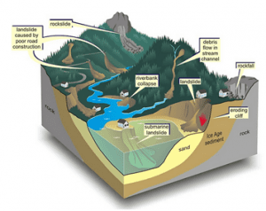
- Falls: Falls are rapid movements of rocks and boulders detached from steep slopes or cliffs along fractures, joints, and bedding planes.
- Topple: It is the forward rotation of a mass of debris or rock out of a slope. The slope failure generally occurs at point near the base of the block of rock.
- Slides: A slide is a downslope movement of material that occurs along a slip surface.
- Rotational slide: In this slide the slide movement is roughly rotational about an axis which is parallel to the ground surface and transverse across the slide.
- Translational slide: In this slide the landslide mass moves along a planar surface with rotation or backward tilting
TYPES OF FLOWS
- Debris flow: It is a form of rapid mass movement in which a combination of loose soil, rock, organic matter, slurry that flows downslope. They are commonly caused by intense precipitation or rapid snow melt.
- Earth flow: It is down slope viscous flow of fine-grained material saturated with water.
- Mudflow: A mudflow is wet or viscous fluid mass of fine- and coarse-grained material flows rapidly along drainage channels.
- Creep: Creep is the slow, steady, downward movement of material under gravity occurs in large area.
LAND SUBSIDENCE
- According to the United States Geological Survey (USGS), land subsidence is a gradual settling or sudden sinking of the Earth’s surface due to the removal or displacement of sub-surface earth materials.
- Subsidence (sinking) of the ground because of underground material movement is most often caused by the removal of water, oil, natural gas, or mineral resources out of the ground by pumping, fracking, or mining activities.
- Subsidence can also be caused by natural events such as earthquakes, soil compaction, glacial isostatic adjustment, erosion, sinkhole formation, and adding water to fine soils deposited by wind (a natural process known as loess deposits).
- The recent incident of Joshimath in Uttarakhand is termed to be an event of land subsidence.
LANDSLIDE
- A landslide is defined as the sudden movement of a mass of rock, debris, or earth down a slope.
- They are a type of mass wasting, which denotes any downward movement of soil and rock under the direct influence of gravity.
- The term landslide encompasses five modes of slope movement: falls, topples, slides, spreads, and flows.
NATURAL AND ANTHROPOGENIC DRIVERS OF LANDSLIDES IN INDIA
India is a country that is prone to landslides due to its diverse geology, topography, and climatic conditions. Landslides can be caused by both natural and anthropogenic factors. Here are some of the major causes of landslides in India:
NATURAL CAUSES
- Geological Conditions: India has varied geological conditions, including soft rocks, steep slopes, and unstable soil conditions. These conditions can make slopes prone to sliding and cause landslides.
o India has a complex geological structure due to its location at the junction of three tectonic plates – the Indian, Eurasian, and Arabian.
o This has led to the formation of several mountain ranges and high-altitude regions that are prone to landslides.
- Heavy Rainfall: Monsoons in India can cause heavy rainfall, which can saturate the soil, reduce its strength and increase its weight, leading to landslides.
- Earthquakes: India is located in a seismically active zone, and earthquakes can cause landslides by destabilizing slopes.
- Erosion: The natural erosion of slopes due to wind and water can weaken the soil, making it more susceptible to landslides.
ANTHROPOGENIC CAUSES
- Deforestation: The removal of trees and vegetation can cause landslides by reducing the slope stability and increasing soil erosion.
- Mining Activities: Mining operations can destabilize slopes and cause landslides due to blasting, excavation, and removal of soil and rock.
- Construction Activities: Improper construction practices, such as improper grading or excavation, can destabilize slopes and cause landslides.
- Land Use Change: Changes in land use, such as urbanization, can increase the number of impervious surfaces, reducing infiltration and increasing runoff, which can lead to landslides.
- Water Management: Poor water management, such as improper dam operations or improper drainage, can increase water pressure on slopes, reducing stability and causing landslides.
IMPLICATIONS OF LANDSLIDES
Landslides in India have a range of implications, including social, economic, environmental, and infrastructure impacts.
- Loss of life and injury: Landslides can cause loss of life and injury to people living in affected areas. In many cases, landslides occur suddenly, leaving people little time to evacuate.
- Damage to infrastructure: Landslides can damage roads, bridges, buildings, and other infrastructure, disrupting transportation and communication networks. This can have significant economic impacts, particularly in rural areas where transportation is often the main means of accessing markets and services.
- Economic losses: Landslides can have significant economic impacts, particularly in rural areas where agriculture is the main source of income. Damage to crops, livestock, and infrastructure can lead to reduced income and increased food insecurity.
- Environmental degradation: Landslides can cause significant environmental damage, including soil erosion, deforestation, and loss of biodiversity. This can have long-term impacts on soil quality, water resources, and ecosystem services.
- Displacement of communities: Landslides can force people to evacuate their homes, leading to temporary or permanent displacement. This can have significant social impacts, particularly for vulnerable groups such as women, children, and the elderly.
- Reduced tourism revenue: Landslides can also impact the tourism industry in India, particularly in areas known for their scenic beauty or cultural heritage. Disruptions to transportation and damage to infrastructure can deter tourists and reduce revenue.
INDIA’S DISASTER VULNERABILITY
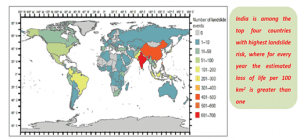
- The vulnerability of India to landslides has been demonstrated by several major landslide events in recent years. In 2013, the Kedarnath landslide in Uttarakhand caused significant loss of life and property. Recently, Joshimath in Uttarakhand faced a similar fate with a series of alarming land subsidence incidents which lead to forced eviction of thousands of people.
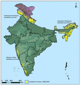
- Approximately 0.42 million sq. km or 12.6% of land area, excluding snow covered area, is prone to landslide hazard. Out of this, 0.18 million sq. km falls in North East Himalaya, including Darjeeling and Sikkim Himalaya; 0.14 million sq. km falls in North West Himalaya (Uttarakhand, Himachal Pradesh and Jammu & Kashmir); 0.09 million sq. km in Western Ghats and Konkan hills (Tamil Nadu, Kerala, Karnataka, Goa and Maharashtra) and 0.01 million sq. km in Eastern Ghats of Aruku area in Andhra Pradesh. In India, landslides mostly occur in the monsoon season. Himalayas and Western Ghats are highly susceptible to mass movements due to hilly topography and heavy rainfall.
- The majority of landslides are triggered by variability in rainfall patterns, while sporadic events such as very heavy rainfall outside the monsoon period (Kedarnath event of 2013) and earthquakes (Sikkim earthquake) cause significant disruption to livelihood and infrastructure.
- The Northernmost Indian states, J&K, Himachal Pradesh, and Uttarakhand, are the worst affected states by the landslides disasters as the majority of the territory falls within the Himalayas.
HOW COULD THE LANDSLIDE ATLAS BE OF HELP?
The landslide atlas released by the Indian Space Research Organization (ISRO) is a valuable resource that can be used in several ways. Some of the uses of the landslide atlas are:
- Disaster management: The landslide atlas can be used to identify areas that are prone to landslides and take preventive measures to avoid loss of life and property. It can also be used to plan rescue and relief operations in the event of a landslide.
- Land use planning: The atlas can be used to identify areas that are unsuitable for development or human habitation due to the risk of landslides. This can help in proper land use planning and prevent the occurrence of disasters.
- Infrastructure planning: The atlas can be used to plan the construction of infrastructure such as roads, railways, and buildings in areas that are safe from landslides.
- Geological studies: The atlas can be used by geologists to study the causes of landslides and the factors that contribute to their occurrence.
- Research: The atlas can be used as a reference for research on landslides and related topics such as climate change, soil erosion, and natural disasters.
NATIONAL DISASTER MANAGEMENT AUTHORITY (NDMA) GUIDELINES FOR THE MANAGEMENT OF LANDSLIDES
- Hazard mapping: The NDMA recommends the preparation of landslide hazard maps, which can help identify areas that are at risk of landslides and guide land-use planning and development activities.
o Pilot projects to be taken up in different regions of the country to carry out detailed studies and monitoring of selected landslides to assess their stability status and estimate risk.
- Early warning systems: The NDMA emphasizes the need for early warning systems that can provide alerts about impending landslides, allowing people to evacuate and take other precautionary measures.
- Land-use planning: The NDMA recommends that land-use planning and development activities should take into account the risks of landslides, and appropriate measures should be taken to minimize the risks.
- Slope stabilization: The NDMA recommends the use of appropriate slope stabilization measures to help reduce the risks of landslides, such as the construction of retaining walls or the use of vegetation to hold the soil in place.
- Preparedness measures: The NDMA recommends that communities and organizations should develop and implement preparedness measures, including emergency response plans and training programs.
o Setting up of institutional mechanisms for generating awareness and preparedness about landslide hazard among various stakeholders.Establishment of an autonomous national centre for landslide research, studies and management.
- Post-landslide measures: The NDMA recommends that post-landslide measures should be taken to restore essential services and infrastructure, as well as to provide support to affected communities.
o Complete site-specific studies of major landslides and plan treatment measures and encourage state governments to continue these measures.
THE WAY FORWARD: A MULTI-PRONGED APPROACH FOR MITIGATING LANDSLIDES
Mitigating landslides in India requires a comprehensive approach that involves various stakeholders, including government agencies, local communities, and civil society organizations.
- Strengthen early warning systems: The government should continue to invest in early warning systems that can alert people living in landslide-prone areas. These systems should be equipped with modern technology, such as satellite imagery and remote sensing, to improve the accuracy of the warning and ensure that people have sufficient time to evacuate.
- Geological Survey of India (GSI) in collaboration with the British Geological Survey (BGS) under the multi-consortium LANDSLIP project recently developed a prototype regional Landslide Early Warning System (LEWS) for India, and the same is currently being evaluated and tested by GSI in two pilot areas in India(Darjeeling. West Bengal, and the Nilgiris, Tamil Nadu).
- Enhance infrastructure development: The government should focus on developing infrastructure that is resilient to landslides. This can include building retaining walls, stabilizing slopes, and improving drainage systems. The government should also ensure that roads and bridges are built to withstand heavy rainfall and landslides.
- Promote reforestation and sustainable land use: The government should promote reforestation in areas that are prone to landslides. Trees can help stabilize the soil and reduce the risk of landslides. The government should also encourage sustainable land use practices, such as terrace farming, to reduce soil erosion and improve soil stability.
- Conduct more research and mapping: The government should invest in research and mapping to identify areas that are most vulnerable to landslides. This information can help local communities and authorities to take appropriate measures to prevent and manage landslides.
- Strengthen disaster management plans: The government should continue to strengthen disaster management plans to ensure that they are effective in responding to landslides. The plans should be regularly reviewed and updated to ensure that they are relevant to the changing landscape and the needs of the local communities.
- Build community awareness and capacity: The government should conduct awareness campaigns and capacity-building programs to educate local communities about the risks of landslides and how to prevent and manage them. This can include training on emergency response, early warning systems, and sustainable land use practices.
THE CONCLUSION: Mitigating landslides in India requires a multi-pronged approach that involves investment in infrastructure, reforestation, sustainable land use practices, research, and community engagement. The government should continue to work with various stakeholders to address the root causes of landslides and minimize their impact on people’s lives and livelihoods. In this endeavour of the government, the landslide atlas released by ISRO could be a valuable resource that can help in mitigating the risk of landslides and improving disaster management.
QUESTIONS
- “Technological innovations such as satellite mapping and remote sensing offer solutions for predicting and preventing landslides in India.” Discuss in the light of recently released the Landslide Atlas of India.
- India’s topography and geology make it particularly susceptible to landslides, which has potential implications for the country’s infrastructure and economy. Comment.
