Introduction:
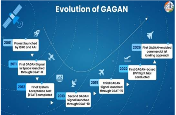
GAGAN (GPS Aided GEO Augmented Navigation) is India’s indigenous Satellite-Based Augmentation System (SBAS), jointly developed by ISRO and the Airports Authority of India (AAI). Operational since 2015, it enhances the accuracy, reliability and integrity of GPS signals. GAGAN is emerging as a strategic component of India’s indigenous navigation ecosystem, supporting sectors such as maritime transport, railways, disaster management, defence and geospatial mapping, while strengthening the vision of Aatmanirbhar Bharat.
Need for GAGAN
Modern aviation demands highly accurate and uninterrupted navigation, as even minor positioning errors can compromise flight safety.
-
- Conventional GPS signals are vulnerable to atmospheric disturbances and signal inaccuracies, making them inadequate for precision approaches and landings.
- To address these limitations, India developed GAGAN, which augments GPS by providing real-time correction and integrity information, thereby ensuring safer and more reliable air navigation across the Indian Flight Information Region (FIR).
How GAGAN Strengthens India’s Navigation Ecosystem
1. Enhancing Navigation Accuracy: GAGAN continuously monitors GPS signals through a network of Indian Reference Stations (INRES) and processes them at Indian Master Control Centres (INMCC) before transmitting corrected navigation information via geostationary satellites. This significantly improves positioning accuracy and immediately alerts pilots whenever GPS signals become unreliable, thereby enhancing aviation safety.
2. Strengthening Indigenous Navigation Capability: GAGAN complements NavIC, India’s indigenous regional navigation satellite system. While NavIC provides independent Positioning, Navigation and Timing (PNT) services, GAGAN enhances GPS signals for precision aircraft navigation and landing. Together, they reduce India’s dependence on foreign navigation systems and strengthen strategic autonomy in critical technologies.
3. Promoting Global Interoperability: Developed in accordance with International Civil Aviation Organization (ICAO) standards, GAGAN is interoperable with global augmentation systems such as WAAS (USA), EGNOS (Europe) and MSAS (Japan). Notably, it is the first SBAS certified for the equatorial region, placing India among a select group of countries possessing operational satellite-based augmentation capabilities.
4. Expanding Multi-Sectoral Applications: Although designed primarily for aviation, GAGAN’s high-precision navigation capability has expanded its utility across multiple sectors.
-
-
-
- Civil Aviation: Precision approach and satellite-based landing systems.
- Maritime Navigation: Improved positioning for coastal and offshore operations.
- Railways & Road Transport: Intelligent transport systems and fleet management.
- Disaster Management: Accurate location tracking during emergencies.
- Surveying & Mapping: High-precision geospatial surveys.
- Defence: Enhanced navigation support for strategic operations.
- Telecommunications: Reliable network synchronisation
-
-

Challenges
-
- While GAGAN’s precision landing capabilities are fully certified, commercial implementation is slowed by the high cost of retrofitting legacy aircraft with SBAS-compliant receivers. Budget airlines delay these cockpit updates due to immediate capital expenditure constraints.
- Technical briefs indicate that during peak solar cycle periods, the equatorial ionosphere experiences intense plasma bubble fluctuations. These anomalies can occasionally test the real-time correction limits of the INMCC algorithms, demanding continuous hardware calibration.
- While sectors like maritime transport and asset logistics benefit from GAGAN, mass commercial monetization remains low. Private consumer apps continue to rely on standard US GPS or basic hybrid chips, leaving GAGAN underutilized in the consumer tech space.
- PRS Legislative Research (The Statutory Vacuum in Space-Based Liability Rules): Legal evaluations highlight the absence of a statutory national space and navigation act to define third-party liability boundaries.
- GAGAN removes the need for physical ground-based ILS hardware, several tier-3 regional airfields under the UDAN scheme lack the updated ground survey coordinate mapping required to design certified GAGAN satellite approach plates.
Way Forward
-
- Parliament should pass a comprehensive legal framework to codify automated signal liability limits, define third-party indemnifications for AAI-ISRO, and protect domestic positioning data privacy.
- The Ministry of Civil Aviation should enforce a phased statutory timeline requiring all commercial aircraft operating within the Indian FIR to install certified SBAS receivers, accelerating fleet-wide integration.
- Introducing Fiscal Incentives for Domestic Chipset Integration to drive commercial monetization, the government should introduce customized fiscal credits for smartphone and telematics manufacturers who embed indigenous dual-channel GAGAN/NavIC chips into consumer hardware.
- ISRO should update the INMCC processing layers with advanced machine-learning models trained on decadal solar data, enhancing the system’s resilience against equatorial plasma bubbles during high solar activity.
- Utilizing the GIS capabilities of the PM GatiShakti master plan to run fast-track geodetic surveys across all regional airstrips, designing certified GAGAN landing profiles to expand safe rural flight connectivity.
Conclusion:
The structural transformation of India’s aerospace ecosystem under GAGAN highlights a successful shift into a globally competitive, self-reliant navigation superpower. Resolving commercial avionics retrofitting deadlocks and expanding indigenous chipset integration will ensure that this satellite augmentation network remains a resilient foundation.
Spread the Word