Context
A powerful earthquake measuring around 7.8 magnitude struck the Mindanao region of the Philippines on 8 June 2026, causing significant damage to infrastructure, triggering tsunami warnings across the region, and resulting in multiple casualties. Authorities launched large-scale rescue and relief operations as aftershocks continued to affect the region.
The disaster once again highlights the vulnerability of Southeast Asia’s Pacific Ring of Fire region to major seismic events.
About Mindanao
Mindanao is the second-largest island of the Philippines and forms the southern part of the country. It is home to more than 25 million people and serves as an important hub for agriculture, fisheries, and trade.
The region has historically experienced frequent earthquakes due to its proximity to active tectonic boundaries and deep ocean trenches.
Why is the Philippines Prone to Earthquakes?
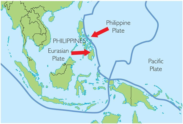
The Philippines lies along the Pacific Ring of Fire, a horseshoe-shaped zone characterized by intense seismic and volcanic activity.
Key Reasons:
-
- Convergence of the Philippine Sea Plate and Eurasian Plate.
- Presence of multiple active faults and subduction zones.
- Frequent tectonic movements beneath the Philippine Mobile Belt.
- Numerous deep-sea trenches such as the Philippine Trench and Cotabato Trench.
As a result, the country experiences thousands of earthquakes annually, although only a few are destructive.
Historical Earthquakes in Mindanao
Mindanao has witnessed several devastating earthquakes in the past:
1976 Moro Gulf Earthquake
-
- Magnitude: 8.0
- Triggered a massive tsunami.
- Claimed between 5,000 and 8,000 lives.
- Remains one of the deadliest disasters in Philippine history.
2002 Mindanao Earthquake
-
- Magnitude: 7.5
- Generated tsunami waves.
- Caused extensive infrastructure damage and casualties.
2023 Mindanao Earthquake
-
- Magnitude: 7.6
- Triggered tsunami warnings across the region.
- Resulted in deaths, injuries, and widespread damage.
2025 Davao Oriental Earthquakes
-
- Twin earthquakes measuring above 7 magnitude.
- Caused major damage and displacement in eastern Mindanao.
Impact of the 2026 Earthquake
Human Impact
-
- Multiple fatalities and hundreds of injuries were reported.
- Panic was witnessed in schools, public institutions, and residential areas.
- Thousands were evacuated from coastal zones.
Infrastructure Damage
-
- Buildings collapsed in General Santos and nearby towns.
- Roads, bridges, schools, and hospitals suffered damage.
- Power and communication disruptions affected rescue operations.
Tsunami Threat
-
- Tsunami alerts were issued for parts of the Philippines, Indonesia, Malaysia, and neighboring regions.
- Though the warning was later downgraded, the event demonstrated the interconnected nature of hazards in the Pacific Basin.
Lessons for Disaster Management
The Mindanao earthquake underlines the importance of:
-
- Earthquake-resilient infrastructure.
- Early warning systems.
- Community preparedness and evacuation drills.
- Regional cooperation for tsunami monitoring.
- Strengthening urban planning in seismic zones.
- Investment in disaster-resilient public infrastructure.
Relevance for India
India also faces significant seismic risks, particularly in:
-
- Himalayan Region
- Northeast India
- Andaman & Nicobar Islands
- Kutch Region of Gujarat
Events such as the Mindanao earthquake provide valuable lessons for India’s disaster management framework, especially regarding earthquake-resistant construction, early warning systems, and community preparedness.
Conclusion
The 2026 Mindanao earthquake serves as a stark reminder that natural disasters continue to pose significant challenges to societies located along tectonically active regions. While earthquakes cannot be prevented, their impacts can be minimized through scientific planning, resilient infrastructure, efficient governance, and public awareness. Strengthening disaster preparedness today remains the most effective safeguard against future seismic catastrophes.
Spread the Word