Day-791
Quiz-summary
0 of 20 questions completed
Questions:
- 1
- 2
- 3
- 4
- 5
- 6
- 7
- 8
- 9
- 10
- 11
- 12
- 13
- 14
- 15
- 16
- 17
- 18
- 19
- 20
Information
DAILY MCQ
You have already completed the quiz before. Hence you can not start it again.
Quiz is loading...
You must sign in or sign up to start the quiz.
You have to finish following quiz, to start this quiz:
Results
0 of 20 questions answered correctly
Your time:
Time has elapsed
You have reached 0 of 0 points, (0)
Categories
- Not categorized 0%
- 1
- 2
- 3
- 4
- 5
- 6
- 7
- 8
- 9
- 10
- 11
- 12
- 13
- 14
- 15
- 16
- 17
- 18
- 19
- 20
- Answered
- Review
-
Question 1 of 20
1. Question
In the context of Bomb Cyclones, consider the following statements:
1. Bomb cyclones are characterised by a rapid fall in its central pressure within a duration of 24 hours.
2. They are more commonly formed in the tropical latitudes.
Which of the statements given above is/are correct?
Correct
Answer. A
Explanation-
-
- Statement 1 is correct- Bomb cyclone is a term given by meteorologists to a storm that appears to intensify rapidly, with its central air pressure dropping to at least 24 millibars in 24 hours.
- They are referred to as ‘bomb’ cyclones due to the explosive power of these storms caused by the rapid fall in pressure.
- The storm brings with it an array of weather ranging from blizzards to severe thunderstorms to heavy precipitation.
- Statement 2 is incorrect- Bomb cyclones are a characteristic feature of mid-latitudes between the tropics and polar regions. These types of storms are most common on the east coast of the US and Canada, where the cool land and warm Gulf Stream current provide optimal conditions for a bomb cyclone to develop.
- Bombogenesis can happen when a cold air mass collides with a warm air mass, such as air over warm ocean waters.
- The intensification required to classify as “bombogenesis” varies by latitude. At 60 degrees latitude, it is a drop of at least 24 millibars (24 hectopascals) over 24 hours. At the latitude of New York City, the required pressure drop is about 17.8 millibars (17.8 hectopascals) over 24 hours.
Incorrect
Answer. A
Explanation-
-
- Statement 1 is correct- Bomb cyclone is a term given by meteorologists to a storm that appears to intensify rapidly, with its central air pressure dropping to at least 24 millibars in 24 hours.
- They are referred to as ‘bomb’ cyclones due to the explosive power of these storms caused by the rapid fall in pressure.
- The storm brings with it an array of weather ranging from blizzards to severe thunderstorms to heavy precipitation.
- Statement 2 is incorrect- Bomb cyclones are a characteristic feature of mid-latitudes between the tropics and polar regions. These types of storms are most common on the east coast of the US and Canada, where the cool land and warm Gulf Stream current provide optimal conditions for a bomb cyclone to develop.
- Bombogenesis can happen when a cold air mass collides with a warm air mass, such as air over warm ocean waters.
- The intensification required to classify as “bombogenesis” varies by latitude. At 60 degrees latitude, it is a drop of at least 24 millibars (24 hectopascals) over 24 hours. At the latitude of New York City, the required pressure drop is about 17.8 millibars (17.8 hectopascals) over 24 hours.
-
Question 2 of 20
2. Question
Which one of the following statements is incorrect in the context of interior of the earth?
Correct
Answer. A
Explanation-
-
- Statement 1 is incorrect- The mantle or mesosphere lies immediately beneath the crust or lithosphere. It is about 2900 km thick and makes up a whopping 84% of the total volume of the Earth.
The crust makes up less than 1% of the Earth’s volume.
The core constitutes nearly 15% of earth’s volume and 32.5% of earth’s mass.
-
- Statement 2 is correct- The upper mantle extending from the crust to a depth of about 650 km, includes the asthenosphere which occupies the upper 300 to 400 km. The rocks in the asthenosphere behave as both a plastic and an elastic solid. The matter possessing these remarkable properties is an elastic-viscous substance- it can be elastic and plastic at the same time, depending on whether the forces that tend to deform it are applied and released suddenly or steadily.
- Statement 3 is correct- The lithosphere is the solid, outer part of the Earth, extending to a depth of about 100 km. The lithosphere includes both the crust and the brittle upper portion of the mantle. It is both the coolest and the most rigid layer of the Earth.
- Statement 4 is correct- The rocks that make up the mantle are mostly silicates- a wide variety of compounds that share a silicon and oxygen structure. The mantle comprises very dense rocks rich in olivine. Other silicates found in the mantle include garnet and pyroxene.
The other major type of rock found in the mantle is magnesium oxide.
Incorrect
Answer. A
Explanation-
-
- Statement 1 is incorrect- The mantle or mesosphere lies immediately beneath the crust or lithosphere. It is about 2900 km thick and makes up a whopping 84% of the total volume of the Earth.
The crust makes up less than 1% of the Earth’s volume.
The core constitutes nearly 15% of earth’s volume and 32.5% of earth’s mass.
-
- Statement 2 is correct- The upper mantle extending from the crust to a depth of about 650 km, includes the asthenosphere which occupies the upper 300 to 400 km. The rocks in the asthenosphere behave as both a plastic and an elastic solid. The matter possessing these remarkable properties is an elastic-viscous substance- it can be elastic and plastic at the same time, depending on whether the forces that tend to deform it are applied and released suddenly or steadily.
- Statement 3 is correct- The lithosphere is the solid, outer part of the Earth, extending to a depth of about 100 km. The lithosphere includes both the crust and the brittle upper portion of the mantle. It is both the coolest and the most rigid layer of the Earth.
- Statement 4 is correct- The rocks that make up the mantle are mostly silicates- a wide variety of compounds that share a silicon and oxygen structure. The mantle comprises very dense rocks rich in olivine. Other silicates found in the mantle include garnet and pyroxene.
The other major type of rock found in the mantle is magnesium oxide.
-
Question 3 of 20
3. Question
Consider the following statements about the cultivation of rubber:
1. Rubber is essentially a tropical crop.
2. Tripura is the largest producer of rubber in India.
3. Rubber can grow well in areas receiving rainfall in the range 100-125 cm.
How many of the statements given above are incorrect?
Correct
Answer. B
Explanation-
Statement 1 is correct- Rubber is essentially an equatorial crop, but under special conditions, it is also grown in tropical and sub-tropical areas.
Rubber is an important industrial raw material. It is mainly grown in Kerala, Tamil Nadu, Karnataka and Andaman and Nicobar Islands and Garo hills of Meghalaya.
Statement 2 is incorrect- Kerala is the largest producer of rubber in India, followed by Tripura.
Globally, Thailand is the largest producer of rubber, followed by Indonesia. Thailand alone contributes more than 30%(approx. 35%) of the total global rubber production.
Statement 3 is incorrect- It requires moist and humid climate with rainfall of more than 200 cm and temperature above 25°C.
Incorrect
Answer. B
Explanation-
Statement 1 is correct- Rubber is essentially an equatorial crop, but under special conditions, it is also grown in tropical and sub-tropical areas.
Rubber is an important industrial raw material. It is mainly grown in Kerala, Tamil Nadu, Karnataka and Andaman and Nicobar Islands and Garo hills of Meghalaya.
Statement 2 is incorrect- Kerala is the largest producer of rubber in India, followed by Tripura.
Globally, Thailand is the largest producer of rubber, followed by Indonesia. Thailand alone contributes more than 30%(approx. 35%) of the total global rubber production.
Statement 3 is incorrect- It requires moist and humid climate with rainfall of more than 200 cm and temperature above 25°C.
-
Question 4 of 20
4. Question
Consider the following statements:
1. The International Rice Research Institute is located in Philippines.
2. The National Rice Research Institute is based in Bhopal, Madhya Pradesh.
3. Pokkali is a special rice variety which is resistant to pests.
How many of the above statements are correct?
Correct
Answer. A
Explanation-
Statement 1 is correct- The International Rice Research Institution (IRRI) is located in the Philippines. It has developed over 400 improved rice varieties and better farm practices and technologies for enhanced rice productivity in India.
Statement 2 is incorrect- The National Rice Research Institute is one of the institutes of ICAR under the Crop Science Division. It is based in Cuttack, Odisha.
Statement 3 is incorrect- Pokkali rice is cultivated in Kerala, particularly in the districts of Ernakulam, Thrissur and Alapuzzha at the onset of South-West monsoon in India. It is resistant to saline conditions which makes it unique.
Also, it can withstand the flooding conditions. This variety of rice is grown organically in the water-logged coastal regions of Kerala.
The Pokkali rice fields during the peak saline season after paddy harvest are devoted for fisheries, in particular the shrimp culture.
Incorrect
Answer. A
Explanation-
Statement 1 is correct- The International Rice Research Institution (IRRI) is located in the Philippines. It has developed over 400 improved rice varieties and better farm practices and technologies for enhanced rice productivity in India.
Statement 2 is incorrect- The National Rice Research Institute is one of the institutes of ICAR under the Crop Science Division. It is based in Cuttack, Odisha.
Statement 3 is incorrect- Pokkali rice is cultivated in Kerala, particularly in the districts of Ernakulam, Thrissur and Alapuzzha at the onset of South-West monsoon in India. It is resistant to saline conditions which makes it unique.
Also, it can withstand the flooding conditions. This variety of rice is grown organically in the water-logged coastal regions of Kerala.
The Pokkali rice fields during the peak saline season after paddy harvest are devoted for fisheries, in particular the shrimp culture.
-
Question 5 of 20
5. Question
Consider the following ports:
1. Odessa
2. Constanta
3. Bandar Anzali
4. Baku
How many of the above ports are located along the Black Sea?
Correct
Answer. B
Explanation-
While the Constanta port (Romania) and Odessa port(Ukraine) lie along the shores of the Black Sea, Bandar Azali port(Iran) and Baku port(Azerbaijan) are located along the Caspian Sea.
Ports located along the Black Sea:
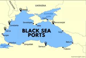
There exist more than 40 ports located along the Black Sea. Some of the most prominent sea ports are as follows-
-
- Port of Constanta, the largest black seaport and the biggest port of
- Port of Odessa, the main Ukrainian seaport and the largest city on the Black Sea.
- Port of Novorossiysk, the main Russian port on the Black Sea and the leading Russian port for exporting grain.
- Port of Varna, the largest Bulgarian port and a major tourist destination.
- Port of Theodosia, a historic port and resort town in
Ports located along the Caspian Sea:
The Caspian Sea is a landlocked water body, often called the world’s largest lake, situated between Europe and Asia. It is surrounded by five nations; Kazakhstan, Russia, Turkmenistan, Iran and Azerbaijan.
-
- Baku Port, Azerbaijan– situated on the southern banks of the Absheron Peninsula, on the Baku Bay.
- Aktau Port, Kazakhstan– situated south of the Mangyshlak Peninsula on the eastern coast of the Caspian Sea.
- Astrakhan Port, Russia- It lies at the mouth of the Volga River on the Volga-Caspian Canal. It is a crucial shipping hub where the Caspian Sea and Volga waterways cross.
- Turkmenbashi Port, Turkmenistan– The Turkmenbashi seaport is the biggest harbour and the main cargo and passenger port in Turkmenistan.
- Bandar Anzali Port, Iran- It lies on the northern coast of Iran on the Caspian Sea.
- Port of Amirabad, Iran- It is a multipurpose facility dealing with containers, RORO, dry bulk and oil.
- Makhachkala Port, Russia- Makhachkala is the socio-economic, educational and scientific centre of the North Caucasus. It has a principal seaport on the southwestern coast of the Caspian Sea
- Port of Kuryk, Kazakhstan- Kuryk Port is located on the coast of the Caspian Sea in Kazakhstan’s Mangistau region.
- Neka Port, Iran- Neka lies in Iran and handles mainly oil. The Neka Oil Terminal is situated in Mazandaran Province, on the southern rim of the Caspian Sea.
Additional Information:
The United Nations and Turkey brokered the Black Sea Grain Initiative with Russia and Ukraine in July 2022 to help alleviate a global food crisis worsened by Moscow’s invasion and blockade of Ukrainian ports.
The initiative aims at facilitating the safe passage of commercial vessels carrying grain, foodstuffs, and fertilizers including ammonia, in and out of three Ukrainian ports: Odessa, Chornomorsk and Yunzhny/Pivdennyi.
Incorrect
Answer. B
Explanation-
While the Constanta port (Romania) and Odessa port(Ukraine) lie along the shores of the Black Sea, Bandar Azali port(Iran) and Baku port(Azerbaijan) are located along the Caspian Sea.
Ports located along the Black Sea:
There exist more than 40 ports located along the Black Sea. Some of the most prominent sea ports are as follows-
-
- Port of Constanta, the largest black seaport and the biggest port of
- Port of Odessa, the main Ukrainian seaport and the largest city on the Black Sea.
- Port of Novorossiysk, the main Russian port on the Black Sea and the leading Russian port for exporting grain.
- Port of Varna, the largest Bulgarian port and a major tourist destination.
- Port of Theodosia, a historic port and resort town in
Ports located along the Caspian Sea:
The Caspian Sea is a landlocked water body, often called the world’s largest lake, situated between Europe and Asia. It is surrounded by five nations; Kazakhstan, Russia, Turkmenistan, Iran and Azerbaijan.
-
- Baku Port, Azerbaijan– situated on the southern banks of the Absheron Peninsula, on the Baku Bay.
- Aktau Port, Kazakhstan– situated south of the Mangyshlak Peninsula on the eastern coast of the Caspian Sea.
- Astrakhan Port, Russia- It lies at the mouth of the Volga River on the Volga-Caspian Canal. It is a crucial shipping hub where the Caspian Sea and Volga waterways cross.
- Turkmenbashi Port, Turkmenistan– The Turkmenbashi seaport is the biggest harbour and the main cargo and passenger port in Turkmenistan.
- Bandar Anzali Port, Iran- It lies on the northern coast of Iran on the Caspian Sea.
- Port of Amirabad, Iran- It is a multipurpose facility dealing with containers, RORO, dry bulk and oil.
- Makhachkala Port, Russia- Makhachkala is the socio-economic, educational and scientific centre of the North Caucasus. It has a principal seaport on the southwestern coast of the Caspian Sea
- Port of Kuryk, Kazakhstan- Kuryk Port is located on the coast of the Caspian Sea in Kazakhstan’s Mangistau region.
- Neka Port, Iran- Neka lies in Iran and handles mainly oil. The Neka Oil Terminal is situated in Mazandaran Province, on the southern rim of the Caspian Sea.
Additional Information:
The United Nations and Turkey brokered the Black Sea Grain Initiative with Russia and Ukraine in July 2022 to help alleviate a global food crisis worsened by Moscow’s invasion and blockade of Ukrainian ports.
The initiative aims at facilitating the safe passage of commercial vessels carrying grain, foodstuffs, and fertilizers including ammonia, in and out of three Ukrainian ports: Odessa, Chornomorsk and Yunzhny/Pivdennyi.
-
Question 6 of 20
6. Question
Consider the following statements:
Statement I- Vizag port leads among all the major ports of India in the export of sea food.
Statement II- Vizag port is the deepest port among all the major ports in India.
Which of the following is correct in respect of the above statements?
Correct
Answer. B
Explanation–
Statement 1 is correct- Vizag or Visakhapatnam port (Andhra Pradesh) leads among all major ports of India in the export of sea food. It contributed around 26.5% (in value) in the total sea food export from India in the financial year 2021-22.
Statement 2 is correct but does not explain statement 1- Vishakhapatnam port is the deepest major port in India.
The high exports of sea food from the ports of Andhra Pradesh are attributed to the highest fish production by the state of Andhra Pradesh in India. Andhra Pradesh contributes nearly 30% of the total fish production in the country. Frozen shrimp continued to be the major export item in terms of quantity.
Incorrect
Answer. B
Explanation–
Statement 1 is correct- Vizag or Visakhapatnam port (Andhra Pradesh) leads among all major ports of India in the export of sea food. It contributed around 26.5% (in value) in the total sea food export from India in the financial year 2021-22.
Statement 2 is correct but does not explain statement 1- Vishakhapatnam port is the deepest major port in India.
The high exports of sea food from the ports of Andhra Pradesh are attributed to the highest fish production by the state of Andhra Pradesh in India. Andhra Pradesh contributes nearly 30% of the total fish production in the country. Frozen shrimp continued to be the major export item in terms of quantity.
-
Question 7 of 20
7. Question
Consider the following pairs:
Islands, sometimes seen in news – Countries which own them
1. Okinawa – Taiwan
2. Canary – Spain
3. Coco – India
4. Sakhalin – Russia
How many of the above pairs are correctly matched?
Correct
Answer. B
Explanation-
Islands in news Country which owns it Description of the island Okinawa islands 
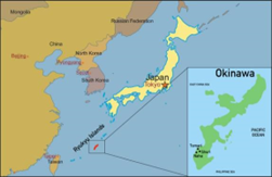
Japan Okinawa islands known as the “Hawaii of Japan”, are located between the East China Sea and Philippines Sea in the Pacific Ocean. The USA has military presence in the Okinawa islands. Recently, the Russian warships have been spotted in the waters near the Okinawa islands of Japan. Russia often carries out joint military drills with China in this region. These activities are viewed by Japan as attack on its territorial integrity and sovereignty.
Canary Islands Spain Canary Islands is a Spanish archipelago off the coast of North-western Africa in the Atlantic Ocean. The Canary Islands are known for earthquakes and volcanoes such as La Palma.
Recently, more than 30 migrants from Western Africa while attempting to reach the Canary Islands have drowned.
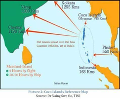
Coco islands Myanmar The Coco islands are a small group of islands in the Northern part of Bay of Bengal in the Indian Ocean. They are considered a part of the Yangon region of Myanmar. India has raised serious concerns over Myanmar allowing China to establish monitoring and surveillance facilities at the Coco islands to tack India’s missile launches off the Balasore test range in Odisha and India’s strategic assets stationed in Visakhapatnam.
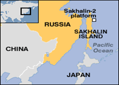
Sakhalin Islands Russia Sakhalin is a Russian island in the Pacific Ocean, north of Japan. It faces the Sea of Okhotsk to the east and north.
Sakhalin 1 is a large, offshore oil and gas field which is located in Russia’s far east. ONGC Videsh (from India) has 20% stake in these oilfields. Russia has invited the investment from India in the Sakhalin 2 oilfields recently, in the backdrop of Russia-Ukraine war.
Incorrect
Answer. B
Explanation-
Islands in news Country which owns it Description of the island Okinawa islands Japan Okinawa islands known as the “Hawaii of Japan”, are located between the East China Sea and Philippines Sea in the Pacific Ocean. The USA has military presence in the Okinawa islands. Recently, the Russian warships have been spotted in the waters near the Okinawa islands of Japan. Russia often carries out joint military drills with China in this region. These activities are viewed by Japan as attack on its territorial integrity and sovereignty.
Canary Islands Spain Canary Islands is a Spanish archipelago off the coast of North-western Africa in the Atlantic Ocean. The Canary Islands are known for earthquakes and volcanoes such as La Palma.
Recently, more than 30 migrants from Western Africa while attempting to reach the Canary Islands have drowned.
Coco islands Myanmar The Coco islands are a small group of islands in the Northern part of Bay of Bengal in the Indian Ocean. They are considered a part of the Yangon region of Myanmar. India has raised serious concerns over Myanmar allowing China to establish monitoring and surveillance facilities at the Coco islands to tack India’s missile launches off the Balasore test range in Odisha and India’s strategic assets stationed in Visakhapatnam.
Sakhalin Islands Russia Sakhalin is a Russian island in the Pacific Ocean, north of Japan. It faces the Sea of Okhotsk to the east and north.
Sakhalin 1 is a large, offshore oil and gas field which is located in Russia’s far east. ONGC Videsh (from India) has 20% stake in these oilfields. Russia has invited the investment from India in the Sakhalin 2 oilfields recently, in the backdrop of Russia-Ukraine war.
-
Question 8 of 20
8. Question
Consider the following statements:
1. Indian coal has high ash content and impurities.
2. The Gondwana coal is free from sulphur and phosphorus.
3. The tertiary rocks bear coals of younger age.
4. Tertiary coal contains high carbon content.
How many of the above statements are correct?
Correct
Answer. B
Explanation-
Statement 1 is correct– Indian coal like any other Gondwana coal is of high ash content and inorganic impurities which is due to the nature of formation of these coal deposits. In general, the original plant materials which were later transformed into coal, were transported by rivers and laid down as fluviatile, lacustrine or deltaic deposits. As a result, the plant materials were contaminated with clay and other detritus minerals, giving rise to high ash content.
Statement 2 is incorrect- The Gondwana coal is almost free from moisture but it contains sulphur and phosphorus in small variable quantities. It includes coking and non-coking, and bituminous as well as sub-bituminous coal.
Statements 3 is correct but statement 4 is incorrect- The tertiary rock systems bear coals of younger age; from 15 to 60 million years and are mainly confined to the extra-Peninsula origin. This coal generally has low carbon and high percentage of moisture and sulphur.
Important areas of tertiary coal include parts of Assam, Meghalaya, Arunachal Pradesh, Nagaland, Himalayan foothills of Darjeeling in west Bengal, Jammu & Kashmir, Uttar Pradesh, Rajasthan, Kerala, Tamil Nadu and Puducherry.
The Gondwana coal is considered to be about 250 million years old. Anthracite is generally not found in the Gondwana fields.
Incorrect
Answer. B
Explanation-
Statement 1 is correct– Indian coal like any other Gondwana coal is of high ash content and inorganic impurities which is due to the nature of formation of these coal deposits. In general, the original plant materials which were later transformed into coal, were transported by rivers and laid down as fluviatile, lacustrine or deltaic deposits. As a result, the plant materials were contaminated with clay and other detritus minerals, giving rise to high ash content.
Statement 2 is incorrect- The Gondwana coal is almost free from moisture but it contains sulphur and phosphorus in small variable quantities. It includes coking and non-coking, and bituminous as well as sub-bituminous coal.
Statements 3 is correct but statement 4 is incorrect- The tertiary rock systems bear coals of younger age; from 15 to 60 million years and are mainly confined to the extra-Peninsula origin. This coal generally has low carbon and high percentage of moisture and sulphur.
Important areas of tertiary coal include parts of Assam, Meghalaya, Arunachal Pradesh, Nagaland, Himalayan foothills of Darjeeling in west Bengal, Jammu & Kashmir, Uttar Pradesh, Rajasthan, Kerala, Tamil Nadu and Puducherry.
The Gondwana coal is considered to be about 250 million years old. Anthracite is generally not found in the Gondwana fields.
-
Question 9 of 20
9. Question
Consider the following statements in the context of fold mountains of the world:
1. The Atlas Mountains are spread across three countries of Africa.
2. The Andes mountains are spread across five countries of South America.
3. The Himalayas span across four countries.
How many of the above statements are correct?
Correct
Answer. A
Explanation-
Statement 1 is correct- The Atlas Mountains which lie in the Maghreb region of Africa, are spread across three countries- Morocco, Algeria and Tunisia. They separate the Sahara Desert from the Mediterranean Sea and Atlantic Ocean.
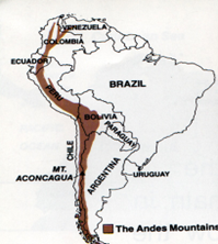
Statement 2 is incorrect- The Andes Mountains are the fold mountains which are spread across seven South American countries:
-
- Peru
- Chile
- Argentina
- Bolivia
- Colombia
- Ecuador
- Venezuela
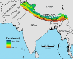
Statement 3 is incorrect- The Himalayas are the young fold mountains which span across five countries:
-
- Pakistan
- Nepal
- India
- China
- Bhutan
Incorrect
Answer. A
Explanation-
Statement 1 is correct- The Atlas Mountains which lie in the Maghreb region of Africa, are spread across three countries- Morocco, Algeria and Tunisia. They separate the Sahara Desert from the Mediterranean Sea and Atlantic Ocean.
Statement 2 is incorrect- The Andes Mountains are the fold mountains which are spread across seven South American countries:
-
- Peru
- Chile
- Argentina
- Bolivia
- Colombia
- Ecuador
- Venezuela
Statement 3 is incorrect- The Himalayas are the young fold mountains which span across five countries:
-
- Pakistan
- Nepal
- India
- China
- Bhutan
-
Question 10 of 20
10. Question
Consider the following statements:
1. Albedo refers to the ability of a surface to absorb the incoming solar radiation.
2. Dark soils generally have higher albedo.
3. Ice and snow-covered surfaces have low albedo.
How many of the above statements are correct?
Correct
Answer. D
Explanation-
Statement 1 is incorrect- Albedo is an expression of the ability of surfaces to reflect (and not absorb) insolation back to space.
Statement 2 is incorrect- Dark surfaces tend to have low albedo, therefore, they have more capacity to absorb the sun rays and not reflect as much. On the contrary, light-coloured surfaces return a large part of the sun rays back to the atmosphere, hence they have high albedo.
Statement 3 is incorrect- Ice and snow-covered areas have high albedo. Snow-covered surfaces on the icesheets reflect 80% of the insolation back to space while snow-free surfaces have lower albedo. Bare ice has an albedo of about 40%, and even lower albedo if summer meltwater pools are standing on the surface.
Incorrect
Answer. D
Explanation-
Statement 1 is incorrect- Albedo is an expression of the ability of surfaces to reflect (and not absorb) insolation back to space.
Statement 2 is incorrect- Dark surfaces tend to have low albedo, therefore, they have more capacity to absorb the sun rays and not reflect as much. On the contrary, light-coloured surfaces return a large part of the sun rays back to the atmosphere, hence they have high albedo.
Statement 3 is incorrect- Ice and snow-covered areas have high albedo. Snow-covered surfaces on the icesheets reflect 80% of the insolation back to space while snow-free surfaces have lower albedo. Bare ice has an albedo of about 40%, and even lower albedo if summer meltwater pools are standing on the surface.
-
Question 11 of 20
11. Question
Consider the following statements:
Statement I- The desert formation can take place in the rainshadow regions.
Statement II- Rainshadow regions receive rainfall, often less than 50 cm per annum.
Which one of the following is correct in respect of the above statements?
Correct
Answer. A
Explanation-
Statement 1 is correct- Desert formation can occur in the rainshadow regions. Some of the rainshadows are found next to the world’s most famous mountain ranges. Death Valley, a desert in the US states of California and Nevada, is so hot and dry because it is in the rain shadow of the Sierra Nevada Mountain range.
Statement 2 is correct and explains statement 1- The areas lying in the rain shadows, interior of the continents and high latitudes receive low precipitation of less than 50 cm a year.
A rainshadow is a patch of land that has been forced to become a desert because mountain ranges blocked all plant-growing, rainy weather. On one side of the mountain, wet weather systems drop rain and snow. On the other side of the mountain—the rain shadow side—all that precipitation is blocked.
When an air mass moves from a low elevation to a high elevation, it expands and cools. This cool air cannot hold moisture as well as warm air. Cool air forms clouds, which drop rain and snow, as it rises up a mountain. After the air mass crosses over the peak of the mountain and starts down the other side, the air warms up and the clouds dissipate. That means there is less rainfall.
Incorrect
Answer. A
Explanation-
Statement 1 is correct- Desert formation can occur in the rainshadow regions. Some of the rainshadows are found next to the world’s most famous mountain ranges. Death Valley, a desert in the US states of California and Nevada, is so hot and dry because it is in the rain shadow of the Sierra Nevada Mountain range.
Statement 2 is correct and explains statement 1- The areas lying in the rain shadows, interior of the continents and high latitudes receive low precipitation of less than 50 cm a year.
A rainshadow is a patch of land that has been forced to become a desert because mountain ranges blocked all plant-growing, rainy weather. On one side of the mountain, wet weather systems drop rain and snow. On the other side of the mountain—the rain shadow side—all that precipitation is blocked.
When an air mass moves from a low elevation to a high elevation, it expands and cools. This cool air cannot hold moisture as well as warm air. Cool air forms clouds, which drop rain and snow, as it rises up a mountain. After the air mass crosses over the peak of the mountain and starts down the other side, the air warms up and the clouds dissipate. That means there is less rainfall.
-
Question 12 of 20
12. Question
Consider the following pairs:
Regions – Well-known for production of
1. Charotar region – Tobacco
2. Araku valley – Coffee
3. Malwa plateau – Oilseeds
How many of the above pairs are correctly matched?
Correct
Answer. C
Explanation-
Option 1 is correctly matched: Charotar region accounts for about 95% of the tobacco production in the state of Gujarat. It covers the districts namely Anand, Kheda and Vadodara.
The tobacco cultivation in Gujarat is rising because of the lesser chances of failure of this crop and also, tobacco doesn’t need pesticides as tobacco itself is a natural pesticide. Tobacco farming keeps the animals away because of the bitter taste of the leaf. So, more and more farmers in Gujarat are opting for tobacco for crop rotation.
Option 2 is correctly matched: The Araku valley in Andhra Pradesh is renowned for cultivation of coffee which has recently received the National Programme for Organic Production (NPOP) certificate from the Agricultural and Processed Food Products Export Development Authority (APEDA), Ministry of Commerce and Industry.
Coffee cultivation in the state of Andhra Pradesh is undertaken organically.
Option 3 is correctly matched: Malwa plateau in Madhya Pradesh is famous for the cultivation of crops such as cotton and soyabean. Oilseeds are also grown in this region.
Madhya Pradesh and Maharashtra constitute almost 89% of the country’s soyabean production. In MP, Malwa region produces almost 50% of the oilseed.
Incorrect
Answer. C
Explanation-
Option 1 is correctly matched: Charotar region accounts for about 95% of the tobacco production in the state of Gujarat. It covers the districts namely Anand, Kheda and Vadodara.
The tobacco cultivation in Gujarat is rising because of the lesser chances of failure of this crop and also, tobacco doesn’t need pesticides as tobacco itself is a natural pesticide. Tobacco farming keeps the animals away because of the bitter taste of the leaf. So, more and more farmers in Gujarat are opting for tobacco for crop rotation.
Option 2 is correctly matched: The Araku valley in Andhra Pradesh is renowned for cultivation of coffee which has recently received the National Programme for Organic Production (NPOP) certificate from the Agricultural and Processed Food Products Export Development Authority (APEDA), Ministry of Commerce and Industry.
Coffee cultivation in the state of Andhra Pradesh is undertaken organically.
Option 3 is correctly matched: Malwa plateau in Madhya Pradesh is famous for the cultivation of crops such as cotton and soyabean. Oilseeds are also grown in this region.
Madhya Pradesh and Maharashtra constitute almost 89% of the country’s soyabean production. In MP, Malwa region produces almost 50% of the oilseed.
-
Question 13 of 20
13. Question
Consider the following statements in the context of the composition of the atmosphere of the Earth:
1. Carbon dioxide is opaque to the incoming solar radiation and transparent to outgoing terrestrial radiation.
2. Methane is among the trace gases found in the atmosphere.
3. The concentration of ozone gas in the atmosphere is more than that of helium.
Which of the statements given above is/are correct?
Correct
Answer. C
Explanation-
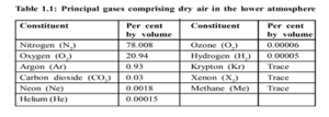
Statement 1 is incorrect- The bulk of the atmosphere is made up of an inert gas, nitrogen which dilutes the oxygen and slows down the process of oxidation. There is a small amount of carbon dioxide which the plants utilize during the process of photosynthesis. It is transparent to the incoming solar radiation but opaque to the outgoing terrestrial radiation. It absorbs a part of terrestrial radiation and reflects back some part of it towards the earth’s surface. It is largely responsible for the greenhouse effect.
Statement 2 is correct– Xenon, Krypton and Methane are the trace gases present in the atmosphere of the Earth.
Statement 3 is incorrect- The concentration of ozone gas in the atmosphere is 0.00006 which is less than that of the Helium (0.00015) in the atmosphere.
Incorrect
Answer. C
Explanation-
Statement 1 is incorrect- The bulk of the atmosphere is made up of an inert gas, nitrogen which dilutes the oxygen and slows down the process of oxidation. There is a small amount of carbon dioxide which the plants utilize during the process of photosynthesis. It is transparent to the incoming solar radiation but opaque to the outgoing terrestrial radiation. It absorbs a part of terrestrial radiation and reflects back some part of it towards the earth’s surface. It is largely responsible for the greenhouse effect.
Statement 2 is correct– Xenon, Krypton and Methane are the trace gases present in the atmosphere of the Earth.
Statement 3 is incorrect- The concentration of ozone gas in the atmosphere is 0.00006 which is less than that of the Helium (0.00015) in the atmosphere.
-
Question 14 of 20
14. Question
Consider the following statements:
Statement I- Temperature inversion is a notable feature of the tropopause.
Statement II- The atmospheric temperature in tropopause decreases at the rate of 1 degree Celsius for every 165 m of height.
Which one of the following is correct in respect of the above statements?
Correct
Answer. C
Explanation-
Statement 1 is correct– The zone between the troposphere and the stratosphere is called the tropopause, wherein the air temperature is about minus 45 degrees Celsius over the poles. The air temperature in the tropopause is nearly constant. The tropopause is essentially an inversion layer.
Normally, temperature decreases with increase in elevation. It is called normal lapse rate. At times, the situation is reversed and the normal lapse rate is inverted. This is known as the inversion of temperature.
Statement 2 is incorrect- The lowermost layer of the atmosphere is called as troposphere. the phenomena of weather and climate occur in this layer. The atmospheric temperature in this layer decreases at the rate of 1 degree Celsius for every 165 m of height. This decrease in air temperature with altitude is because air is compressible and the density of the air decreases with altitude.
Incorrect
Answer. C
Explanation-
Statement 1 is correct– The zone between the troposphere and the stratosphere is called the tropopause, wherein the air temperature is about minus 45 degrees Celsius over the poles. The air temperature in the tropopause is nearly constant. The tropopause is essentially an inversion layer.
Normally, temperature decreases with increase in elevation. It is called normal lapse rate. At times, the situation is reversed and the normal lapse rate is inverted. This is known as the inversion of temperature.
Statement 2 is incorrect- The lowermost layer of the atmosphere is called as troposphere. the phenomena of weather and climate occur in this layer. The atmospheric temperature in this layer decreases at the rate of 1 degree Celsius for every 165 m of height. This decrease in air temperature with altitude is because air is compressible and the density of the air decreases with altitude.
-
Question 15 of 20
15. Question
With reference to ‘Nickel’, recently declared as a ‘Critical Mineral’ by the Government of India, consider the following statements:
1. Nickel is mostly found in association with copper and uranium.
2. It is used as a catalyst in hydrogenation of fats.
3. Indonesia is the world’s largest producer of nickel.
4. Odisha has the highest reserves of nickel in India.
How many of the above statements are correct?
Correct
Answer. D
Explanation-
Statement 1 is correct- Nickel does not occur in free state in nature. It is found in association with copper, uranium and other metals. Important occurrences of nickeliferous limonite are found in the Sukinda valley of Jajajpur district of Odisha, where it occurs as oxide.
Nickel also occurs in sulphide form along with copper mineralisation in the Singhbhum district of Jharkhand. Karnataka, Kerala and Rajasthan also hold the reserves of nickel in India. Polymetallic nodules are another important source of nickel.
Statement 2 is correct- Metallic nickel is used for manufacturing storage batteries and as a catalyst in the process of hydrogenation of fats and oils to make vanaspati.
Nickel is an important alloying material. When alloyed with iron, rust-proof stainless steel is obtained, from which utensils are made. Because of its greater hardness and tensile strength, nickel steel is also used for making armoured plates, motor cars, bullet jackets and in naval construction.
When alloyed with copper or silver, it is used for making coins. Nickel-aluminium alloys are used in making aeroplanes and internal combustion engines.
Statement 3 is correct- Indonesia is the world’s largest producer of nickel, a key element in the lithium-ion batteries used in EVs and renewable energy storage. Indonesia’s industrial parks, particularly those on the islands of Sulawesi and Halmahera have become major hubs for nickel and aluminium processing.
Indonesia’s nickel reserves are the laterite ore kind, which require more processing to become battery-grade nickel than does the sulfide ore found mostly in Canada, Russia and Australia.
Statement 4 is correct- About 92% of the resources of nickel in India are in Odisha. The remaining 8% are distributed in the states of Jharkhand, Nagaland and Karnataka.
Incorrect
Answer. D
Explanation-
Statement 1 is correct- Nickel does not occur in free state in nature. It is found in association with copper, uranium and other metals. Important occurrences of nickeliferous limonite are found in the Sukinda valley of Jajajpur district of Odisha, where it occurs as oxide.
Nickel also occurs in sulphide form along with copper mineralisation in the Singhbhum district of Jharkhand. Karnataka, Kerala and Rajasthan also hold the reserves of nickel in India. Polymetallic nodules are another important source of nickel.
Statement 2 is correct- Metallic nickel is used for manufacturing storage batteries and as a catalyst in the process of hydrogenation of fats and oils to make vanaspati.
Nickel is an important alloying material. When alloyed with iron, rust-proof stainless steel is obtained, from which utensils are made. Because of its greater hardness and tensile strength, nickel steel is also used for making armoured plates, motor cars, bullet jackets and in naval construction.
When alloyed with copper or silver, it is used for making coins. Nickel-aluminium alloys are used in making aeroplanes and internal combustion engines.
Statement 3 is correct- Indonesia is the world’s largest producer of nickel, a key element in the lithium-ion batteries used in EVs and renewable energy storage. Indonesia’s industrial parks, particularly those on the islands of Sulawesi and Halmahera have become major hubs for nickel and aluminium processing.
Indonesia’s nickel reserves are the laterite ore kind, which require more processing to become battery-grade nickel than does the sulfide ore found mostly in Canada, Russia and Australia.
Statement 4 is correct- About 92% of the resources of nickel in India are in Odisha. The remaining 8% are distributed in the states of Jharkhand, Nagaland and Karnataka.
-
Question 16 of 20
16. Question
In the context of clouds and their types, consider the following statements:
1. Cirrus clouds are usually a signal of an approaching storm.
2. The clouds with large vertical extent are entirely made up of ice.
Which of the statements given above is/are correct?
Correct
Answer. D
Explanation– Clouds are formed by the condensation of water vapour around the nuclei of minute dust particles and aerosols in the air. Most clouds are formed by the rising warm and moist air. The ascending air expands and cools until the dew point is reached and some of the moisture condenses into clouds.
Statement 1 is incorrect- It is the cirrostratus clouds which usually indicate the approaching of a storm. The cirrostratus clouds are high clouds which are thin, whitish sheet of cloud covering the whole sky and giving it a milky appearance. These clouds commonly form a halo around the sun and moon.
Cirrus clouds are a type of high clouds which are fibrous with a delicate, silky appearance. When detached and arranged irregularly in the sky, they are harbingers of fair weather. On the other hand, when they are systematically arranged as in bands or connected with cirrostratus or altostratus, they usually foretell wet weather.
Statement 2 is incorrect- The clouds of large vertical extent (high clouds) are not composed entirely of ice crystals. They comprise a mixture of water droplets and ice crystals. The composition of clouds is influenced by the altitude at which it is formed. In most cases, clouds consist of tiny droplets of water but they may also consist of ice particles if the temperature is below freezing point.
Incorrect
Answer. D
Explanation– Clouds are formed by the condensation of water vapour around the nuclei of minute dust particles and aerosols in the air. Most clouds are formed by the rising warm and moist air. The ascending air expands and cools until the dew point is reached and some of the moisture condenses into clouds.
Statement 1 is incorrect- It is the cirrostratus clouds which usually indicate the approaching of a storm. The cirrostratus clouds are high clouds which are thin, whitish sheet of cloud covering the whole sky and giving it a milky appearance. These clouds commonly form a halo around the sun and moon.
Cirrus clouds are a type of high clouds which are fibrous with a delicate, silky appearance. When detached and arranged irregularly in the sky, they are harbingers of fair weather. On the other hand, when they are systematically arranged as in bands or connected with cirrostratus or altostratus, they usually foretell wet weather.
Statement 2 is incorrect- The clouds of large vertical extent (high clouds) are not composed entirely of ice crystals. They comprise a mixture of water droplets and ice crystals. The composition of clouds is influenced by the altitude at which it is formed. In most cases, clouds consist of tiny droplets of water but they may also consist of ice particles if the temperature is below freezing point.
-
Question 17 of 20
17. Question
Consider the following pairs:
Reservoirs, seen in the news – Associated Rivers
1. Gandhi Sagar – Chambal
2. Kishenganga – Jhelum
3. Mettur – Godavari
4. Omkareshwar – Cauvery
How many of the above pairs are correctly matched?
Correct
Answer. B
Explanation-
Option 1 is correctly matched- Gandhi Sagar dam in the state of Madhya Pardesh is built on river Chambal.
Option 2 is correctly matched- Kishenganga hydroelectric project is planned in the state of Jammu & Kashmir to utilise the waters of river Jhelum.
Option 3 is incorrectly matched– Mettur dam forms the Stanley Reservoir. It is located in the state of Tamil Nadu on the river Cauvery.
Option 4 is incorrectly matched- Omkareshwar dam in the state of Madhya Pradesh is built on the river Narmada.
Incorrect
Answer. B
Explanation-
Option 1 is correctly matched- Gandhi Sagar dam in the state of Madhya Pardesh is built on river Chambal.
Option 2 is correctly matched- Kishenganga hydroelectric project is planned in the state of Jammu & Kashmir to utilise the waters of river Jhelum.
Option 3 is incorrectly matched– Mettur dam forms the Stanley Reservoir. It is located in the state of Tamil Nadu on the river Cauvery.
Option 4 is incorrectly matched- Omkareshwar dam in the state of Madhya Pradesh is built on the river Narmada.
-
Question 18 of 20
18. Question
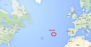
Azores High, recently seen in the news, can be best described as:
Correct
Answer. B
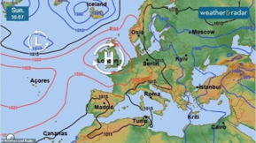
Explanation- Azores High is a subtropical high-pressure system that extends over the eastern subtropical North Atlantic and western Europe during winter. It is associated with anticyclonic winds in the subtropical North Atlantic.
It is formed by dry air aloft descending the subtropics and coincides with the downward branch of the Hadley Circulation.
Recent studies have identified a robust increase in the frequency of extremely large Azores High Area (AHA) events and an overall expansion signal in the winter Azores High over the past 100 years.
Azores High expansion emerged after 1850 and strengthened in the twentieth century, consistent with anthropogenically driven warming.
The study is important to understand the future climate risks posed to productive agricultural sectors such as viticulture and olive plantations across the Iberian Peninsula.
Incorrect
Answer. B
Explanation- Azores High is a subtropical high-pressure system that extends over the eastern subtropical North Atlantic and western Europe during winter. It is associated with anticyclonic winds in the subtropical North Atlantic.
It is formed by dry air aloft descending the subtropics and coincides with the downward branch of the Hadley Circulation.
Recent studies have identified a robust increase in the frequency of extremely large Azores High Area (AHA) events and an overall expansion signal in the winter Azores High over the past 100 years.
Azores High expansion emerged after 1850 and strengthened in the twentieth century, consistent with anthropogenically driven warming.
The study is important to understand the future climate risks posed to productive agricultural sectors such as viticulture and olive plantations across the Iberian Peninsula.
-
Question 19 of 20
19. Question
With reference to the Indian Ocean, consider the following statements:
1. The continental shelf in the Indian Ocean is narrow along the coast of Arabian Sea as compared to that of the Bay of Bengal.
2. Dolphin ridge and Madagascar ridge are found in the Indian ocean.
Which of the statements given above is/are incorrect?
Correct
Answer. C
Explanation- Smaller than the Pacific and the Atlantic, the Indian Ocean is bounded on the north by Asia, on the west by Africa, on the east by Asia and Australia and on the south by Antarctica. The average depth of the ocean is 4,000 m.
Statement 1 is incorrect- The continental shelves of the Indian ocean have a wide variation. It is extensive and broader along the margins of the Arabian Sea as compared to that in the Bay of Bengal.
It is also extensive along the eastern coast of Africa and around Madagascar. Here, it is about 640 km wide, but along the coast of Java and Sumatra, it is comparatively narrow.
The continental shelf is also narrow along the northern coast of Antarctica.
Statement 2 is incorrect- The important ridges in the Indian Ocean are:
-
- Socotra-Chagos
- Maldives
- Chagos-St. Paul
- Indian-Antarctic ridge
- Madagascar ridge
- Atlantic-Antarctic ridge
Dolphin ridge is the mid-oceanic ridge in the North Atlantic Ocean.
Incorrect
Answer. C
Explanation- Smaller than the Pacific and the Atlantic, the Indian Ocean is bounded on the north by Asia, on the west by Africa, on the east by Asia and Australia and on the south by Antarctica. The average depth of the ocean is 4,000 m.
Statement 1 is incorrect- The continental shelves of the Indian ocean have a wide variation. It is extensive and broader along the margins of the Arabian Sea as compared to that in the Bay of Bengal.
It is also extensive along the eastern coast of Africa and around Madagascar. Here, it is about 640 km wide, but along the coast of Java and Sumatra, it is comparatively narrow.
The continental shelf is also narrow along the northern coast of Antarctica.
Statement 2 is incorrect- The important ridges in the Indian Ocean are:
-
- Socotra-Chagos
- Maldives
- Chagos-St. Paul
- Indian-Antarctic ridge
- Madagascar ridge
- Atlantic-Antarctic ridge
Dolphin ridge is the mid-oceanic ridge in the North Atlantic Ocean.
-
Question 20 of 20
20. Question
Consider the following statements:
1. The formation of the moon is linked to a cosmic event termed as ‘degassing’.
2. The early atmosphere of the Earth had more carbon dioxide than today’s atmosphere.
3. Respiration, photosynthesis and volcanic eruption modified the composition of the early atmosphere of the Earth.
How many of the above statements are correct?
Correct
Answer. A
Explanation–
Statement 1 is incorrect- The formation of moon, as a satellite of the earth, is an outcome of ‘giant impact’ or what is described as “the big splat”. A body of the size of one to three times that of mars collided into the earth sometime shortly after the earth was formed. It blasted a large part of the earth into space. This portion of blasted material then continued to orbit the earth and eventually formed into the present moon about 4.44 billion years age.
Statement 2 is correct– The role of volcanoes, photosynthesis and solar winds is crucial in influencing the transformation of the early atmosphere of the Earth. Respiration has no such role in its transformation.
When Earth was formed 4.6 billion years ago from a hot mix of gases and solids, it had almost no atmosphere. The surface was molten. As the earth cooled, an atmosphere formed mainly from gases spewed from the volcanoes. It included Hydrogen Sulphide, Methane, and 10-200 times as much CO2 as today’s atmosphere. After about half a billion years, the Earth’s surface cooled and solidified enough for water to collect on it.
Statement 3 is incorrect- The composition of the atmosphere was modified by the living world through the process of photosynthesis. The early atmosphere, with hydrogen and helium, is supposed to have been stripped off as a result of the solar winds.
During the cooling of the earth, gases and water vapour were released from the interior solid earth. This started the evolution of the present atmosphere. The early atmosphere largely contained water vapour, nitrogen, carbon dioxide, methane, ammonia and very little of free oxygen. The process through which the gases were outpoured from the interior is called degassing.
Continuous volcanic eruptions contributed water vapour and gases to the atmosphere.
However, around 2,500-3,000 million years before the present, the process of photosynthesis got evolved. Oceans began to have the contribution of oxygen through the process of photosynthesis. Eventually, oceans were saturated with oxygen, and 2,000 million years ago, oxygen began to flood the atmosphere.
Incorrect
Answer. A
Explanation–
Statement 1 is incorrect- The formation of moon, as a satellite of the earth, is an outcome of ‘giant impact’ or what is described as “the big splat”. A body of the size of one to three times that of mars collided into the earth sometime shortly after the earth was formed. It blasted a large part of the earth into space. This portion of blasted material then continued to orbit the earth and eventually formed into the present moon about 4.44 billion years age.
Statement 2 is correct– The role of volcanoes, photosynthesis and solar winds is crucial in influencing the transformation of the early atmosphere of the Earth. Respiration has no such role in its transformation.
When Earth was formed 4.6 billion years ago from a hot mix of gases and solids, it had almost no atmosphere. The surface was molten. As the earth cooled, an atmosphere formed mainly from gases spewed from the volcanoes. It included Hydrogen Sulphide, Methane, and 10-200 times as much CO2 as today’s atmosphere. After about half a billion years, the Earth’s surface cooled and solidified enough for water to collect on it.
Statement 3 is incorrect- The composition of the atmosphere was modified by the living world through the process of photosynthesis. The early atmosphere, with hydrogen and helium, is supposed to have been stripped off as a result of the solar winds.
During the cooling of the earth, gases and water vapour were released from the interior solid earth. This started the evolution of the present atmosphere. The early atmosphere largely contained water vapour, nitrogen, carbon dioxide, methane, ammonia and very little of free oxygen. The process through which the gases were outpoured from the interior is called degassing.
Continuous volcanic eruptions contributed water vapour and gases to the atmosphere.
However, around 2,500-3,000 million years before the present, the process of photosynthesis got evolved. Oceans began to have the contribution of oxygen through the process of photosynthesis. Eventually, oceans were saturated with oxygen, and 2,000 million years ago, oxygen began to flood the atmosphere.