Day-714
Quiz-summary
0 of 5 questions completed
Questions:
- 1
- 2
- 3
- 4
- 5
Information
DAILY MCQ
You have already completed the quiz before. Hence you can not start it again.
Quiz is loading...
You must sign in or sign up to start the quiz.
You have to finish following quiz, to start this quiz:
Results
0 of 5 questions answered correctly
Your time:
Time has elapsed
You have reached 0 of 0 points, (0)
Categories
- Not categorized 0%
- 1
- 2
- 3
- 4
- 5
- Answered
- Review
-
Question 1 of 5
1. Question
1. The Southern Cone is a geographical and cultural subregion composed of –
Correct
Answer: D
Explanation:
About Southern Cone Region:
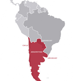
● The Southern Cone is a geographical and cultural subregion composed of the southernmost areas of South America.
● The name is an indication of the physical shape of the southern portion of the continent.
● The region is located south of the Tropic of Capricorn.
● Traditionally, it covers Argentina, Chile, and Uruguay, bounded on the west by the Pacific Ocean and on the east by the Atlantic Ocean.
● In terms of social, economic and political geography, the Southern Cone comprises Argentina, Chile, and Uruguay, and sometimes includes Brazil’s four southernmost states (Paraná, Rio Grande do Sul, Santa Catarina, and São Paulo).
● In its broadest definition, considering common history and geography, it also includes Paraguay, another Spanish-speaking.
 Incorrect
Answer: D
Explanation:
About Southern Cone Region:
● The Southern Cone is a geographical and cultural subregion composed of the southernmost areas of South America.
● The name is an indication of the physical shape of the southern portion of the continent.
● The region is located south of the Tropic of Capricorn.
● Traditionally, it covers Argentina, Chile, and Uruguay, bounded on the west by the Pacific Ocean and on the east by the Atlantic Ocean.
● In terms of social, economic and political geography, the Southern Cone comprises Argentina, Chile, and Uruguay, and sometimes includes Brazil’s four southernmost states (Paraná, Rio Grande do Sul, Santa Catarina, and São Paulo).
● In its broadest definition, considering common history and geography, it also includes Paraguay, another Spanish-speaking.

-
Question 2 of 5
2. Question
2. Consider the following pairs:
Rivers – Drain into
1. Irrawaddy – Gulf of Thailand
2. Rio Grande – Gulf of Mexico
3. Niger – Gulf of Guinea
How many of the above pairs are correctly matched?Correct
Answer: B
Explanation:
Rivers – Drains into
1. Irrawaddy – Bay of Bengal
2. Rio Grande – Gulf of Mexico
3. Niger – Gulf of Guinea
Pair 1 is matched incorrectly:
About Irrawaddy River:
● The river flows wholly within the territory of Myanmar. It bisects Myanmar from north to south.
● Origin: The Irrawaddy is formed by the confluence of the Nmai and Mali rivers. Both branches rise in mountains in northern Myanmar.
● Length: 2,170 km long.
● Its total drainage area is about 411,000 square km.
● Myanmar’s most important commercial waterway.
Irrawaddy Delta:
● The Irrawaddy Delta is the southernmost part of Myanmar where the Irrawaddy River fans out under tidal influence and flows into the Bay of Bengal and Andaman Sea.

Pair 2 is matched correctly:
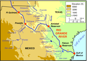
About Rio Grande River:
● Known as the Rio Grande in the United States or the Río Bravo (del Norte) in Mexico.
● It is one of the principal rivers in the southwestern United States and in northern Mexico.
● The length 3,051 km, making it the 4th longest river in the United States and in North America.
● Origin and end: It originates in south-central Colorado in the southern Rockies, in the United States, and flows to the Gulf of Mexico.
● The Rio Grande is the national border between the United States and Mexico, located south of El Paso.


Pair 3 is matched correctly:
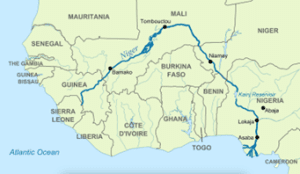
About Niger River:
● The Niger River is located in West Africa.
● Origin: Its source is in the Guinea Highlands in south-eastern Guinea near the Sierra Leone border.
● It runs in a crescent shape through Mali, Niger, on the border with Benin and then through Nigeria, discharging through a massive delta, known as the Niger Delta, into the Gulf of Guinea in the Atlantic Ocean.
● The Niger is the third-longest river in Africa, exceeded by the Nile and the Congo River.
● Its main tributary is the Benue River.


 Incorrect
Answer: B
Explanation:
Rivers – Drains into
1. Irrawaddy – Bay of Bengal
2. Rio Grande – Gulf of Mexico
3. Niger – Gulf of Guinea
Pair 1 is matched incorrectly:
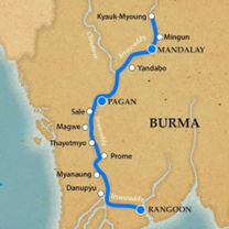
About Irrawaddy River:
● The river flows wholly within the territory of Myanmar. It bisects Myanmar from north to south.
● Origin: The Irrawaddy is formed by the confluence of the Nmai and Mali rivers. Both branches rise in mountains in northern Myanmar.
● Length: 2,170 km long.
● Its total drainage area is about 411,000 square km.
● Myanmar’s most important commercial waterway.
Irrawaddy Delta:
● The Irrawaddy Delta is the southernmost part of Myanmar where the Irrawaddy River fans out under tidal influence and flows into the Bay of Bengal and Andaman Sea.


Pair 2 is matched correctly:
About Rio Grande River:
● Known as the Rio Grande in the United States or the Río Bravo (del Norte) in Mexico.
● It is one of the principal rivers in the southwestern United States and in northern Mexico.
● The length 3,051 km, making it the 4th longest river in the United States and in North America.
● Origin and end: It originates in south-central Colorado in the southern Rockies, in the United States, and flows to the Gulf of Mexico.
● The Rio Grande is the national border between the United States and Mexico, located south of El Paso.


Pair 3 is matched correctly:
About Niger River:
● The Niger River is located in West Africa.
● Origin: Its source is in the Guinea Highlands in south-eastern Guinea near the Sierra Leone border.
● It runs in a crescent shape through Mali, Niger, on the border with Benin and then through Nigeria, discharging through a massive delta, known as the Niger Delta, into the Gulf of Guinea in the Atlantic Ocean.
● The Niger is the third-longest river in Africa, exceeded by the Nile and the Congo River.
● Its main tributary is the Benue River.


-
Question 3 of 5
3. Question
3. In the context of volcanic landforms, ‘Old Faithful’ refers to –
Correct
Answer: B
Explanation:
● Geyser: A geyser is a natural hot spring that erupts with a gush of steam and water.
● Working: A geyser is the product of heat, water, and some plumbing.


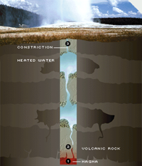
⮚ The heat comes from partially molten rock, or magma.
⮚ Underground water is supplied by rain and melting snow that seep through a vast system of cracks and fissures.
⮚ These same passages provide escape hatches for steam and water exploding upward.
⮚ Mineral deposits narrow these tubes into nozzles at points.
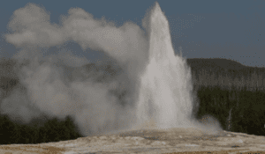
● The most famous of these natural wonders, known for its predictability and beautiful plume, is Old Faithful in Yellowstone National Park. The average interval between its spouting is 78 minutes.
● Uniqueness of the Old Faithful: What makes Old Faithful unique is its relatively regular eruption schedule, which occurs approximately every 60 to 110 minutes. This predictability is due to the consistent size of its underground reservoir, the rate of water flow into the system, and the amount of heat being supplied to the water from the Earth’s interior.


About Yellowstone National Park:
● Yellowstone National Park is an American national park located in the western United States.
● It was the first national park in the US and is also widely held to be the first national park in the world.
● The park is known for its wildlife and its many geothermal features, especially the Old Faithful geyser, one of its most popular.Incorrect
Answer: B
Explanation:
● Geyser: A geyser is a natural hot spring that erupts with a gush of steam and water.
● Working: A geyser is the product of heat, water, and some plumbing.


⮚ The heat comes from partially molten rock, or magma.
⮚ Underground water is supplied by rain and melting snow that seep through a vast system of cracks and fissures.
⮚ These same passages provide escape hatches for steam and water exploding upward.
⮚ Mineral deposits narrow these tubes into nozzles at points.
● The most famous of these natural wonders, known for its predictability and beautiful plume, is Old Faithful in Yellowstone National Park. The average interval between its spouting is 78 minutes.
● Uniqueness of the Old Faithful: What makes Old Faithful unique is its relatively regular eruption schedule, which occurs approximately every 60 to 110 minutes. This predictability is due to the consistent size of its underground reservoir, the rate of water flow into the system, and the amount of heat being supplied to the water from the Earth’s interior.


About Yellowstone National Park:
● Yellowstone National Park is an American national park located in the western United States.
● It was the first national park in the US and is also widely held to be the first national park in the world.
● The park is known for its wildlife and its many geothermal features, especially the Old Faithful geyser, one of its most popular. -
Question 4 of 5
4. Question
4. Consider the following statements:
1. Kolkata port is the only riverine major port in India.
2. Deendayal Port is the only corporatised major port in India.
3. Tamil Nadu is the only state in India having three major ports.
How many of the above statements are correct?Correct
Answer: B
Explanation
Statements 1 and 3 are correct.
Statement 1 is correct:
About Kolkata Port:
● The Kolkata Port is located on the left bank of Hugli River is the first major as well as the only riverine port in India.
● The Haldia Dock Complex (HDC) is located on the right bank of the river at the confluence of Haldi and Hugli rivers.
● It has the longest approach Channel of 145 km.
● The Bhagirathi – Hugli river system is a major distributary of River Ganga in West Bengal. Small rivers like Haldi, Roopnarayan, Damodar, and Churni carry large amounts of sediments into the Hugli River during monsoon season.
● This is a tidal port with severe restriction in draft and very high maintenance dredging. The dynamic nature of the estuary results in frequent shifting of the navigation channels.


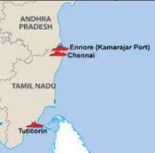
Statement 2 is incorrect: Kamarajar Port (earlier known as Ennore Port is the only corporatized major port of India.)
About Deendayal Port:
● Kandla Port is officially known as Deendayal Port,
● Location: It is a seaport in Kutch district of Gujarat, India. The port is situated in the Kandla Creek and is 90 km from the mouth of Gulf of Kutch.
● Kandla Port was renamed as Deendayal Port in 2017 under the Indian Ports Act, 1908.
● It is about 256 nautical miles southeast of the Port of Karachi in Pakistan and about 430 nautical miles north-northwest of the Port of Mumbai.
● Kandla Port was constructed in the 1950s as the chief seaport serving western India.
● The depth of the channel of port depends on the tide. This channel has a minimum depth of 13 meters.
● It is the largest port of India by volume of cargo handled.
Corporatized Port of India:
● Kamarajar Port is located on the Coromandel Coast about 24 km north of Chennai Port, Chennai.
● Formerly known as the Ennore Port.
● It is the 12th major port of India, and the first port in India which is a public company.
● The port was declared as a major port under the Indian Ports Act, 1908 in March 1999 and incorporated as Ennore Port Limited under the Companies Act, 1956 in October 1999.
● The Kamarajar Port is the only corporatized major port and is registered as a company.
Statement 3 is correct: Tamil nadu is the only state in India having three major ports.
Major Ports in Tamil Nadu: The three Major Ports located in Tamil Nadu which are –
a) Kamarajar Port:
⮚ Kamarajar Port is located on the Coromandel Coast about 24 km north of Chennai Port, Chennai.
⮚ Formerly known as the Ennore Port.
⮚ It is the 12th major port of India, and the first port in India which is a public company.
⮚ The port was declared as a major port under the Indian Ports Act, 1908 in March 1999 and incorporated as Ennore Port Limited under the Companies Act, 1956 in October 1999.
⮚ The Kamarajar Port is the only corporatized major port and is registered as a company.
b) Chennai Port:
⮚ Chennai Port is the second largest container port of India, behind Mumbai’s Jawaharlal Nehru Port also known as Nhava Sheva.
⮚ The port is the largest one in the Bay of Bengal.
⮚ It is the third-oldest port among the 13 major ports of India with official port operations beginning in 1881, although maritime trade started much earlier in 1639 on the undeveloped shore.
⮚ It is an artificial and all-weather port with wet docks.
⮚ It is due to the existence of the port that the city of Chennai eventually became known as the Gateway of South India.
c) V.O. Chidambaranar Port:
⮚ It was formerly known as Tuticorin Port.
⮚ V.O.Chidambaranar Port is located strategically close to the East-West International sea routes on the South Eastern coast of India.
⮚ Located in the Gulf of Mannar, with Sri Lanka on the South East and the large land mass of India on the West, V.O.Chidambaranar Port is well sheltered from the fury of storms and cyclonic winds.
⮚ The port is operational round the clock all through the year.


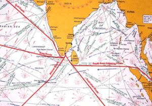
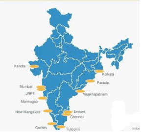
Major Ports in India
● According to the Ministry of Shipping, around 95% of India’s trading by volume and 70% by value is done through maritime transport.
● India has 12 major and 200+ notified minor and intermediate ports.
● Major Ports are-


 Incorrect
Answer: B
Explanation
Statements 1 and 3 are correct.
Statement 1 is correct:
About Kolkata Port:
● The Kolkata Port is located on the left bank of Hugli River is the first major as well as the only riverine port in India.
● The Haldia Dock Complex (HDC) is located on the right bank of the river at the confluence of Haldi and Hugli rivers.
● It has the longest approach Channel of 145 km.
● The Bhagirathi – Hugli river system is a major distributary of River Ganga in West Bengal. Small rivers like Haldi, Roopnarayan, Damodar, and Churni carry large amounts of sediments into the Hugli River during monsoon season.
● This is a tidal port with severe restriction in draft and very high maintenance dredging. The dynamic nature of the estuary results in frequent shifting of the navigation channels.


Statement 2 is incorrect: Kamarajar Port (earlier known as Ennore Port is the only corporatized major port of India.)
About Deendayal Port:
● Kandla Port is officially known as Deendayal Port,
● Location: It is a seaport in Kutch district of Gujarat, India. The port is situated in the Kandla Creek and is 90 km from the mouth of Gulf of Kutch.
● Kandla Port was renamed as Deendayal Port in 2017 under the Indian Ports Act, 1908.
● It is about 256 nautical miles southeast of the Port of Karachi in Pakistan and about 430 nautical miles north-northwest of the Port of Mumbai.
● Kandla Port was constructed in the 1950s as the chief seaport serving western India.
● The depth of the channel of port depends on the tide. This channel has a minimum depth of 13 meters.
● It is the largest port of India by volume of cargo handled.
Corporatized Port of India:
● Kamarajar Port is located on the Coromandel Coast about 24 km north of Chennai Port, Chennai.
● Formerly known as the Ennore Port.
● It is the 12th major port of India, and the first port in India which is a public company.
● The port was declared as a major port under the Indian Ports Act, 1908 in March 1999 and incorporated as Ennore Port Limited under the Companies Act, 1956 in October 1999.
● The Kamarajar Port is the only corporatized major port and is registered as a company.
Statement 3 is correct: Tamil nadu is the only state in India having three major ports.
Major Ports in Tamil Nadu: The three Major Ports located in Tamil Nadu which are –
a) Kamarajar Port:
⮚ Kamarajar Port is located on the Coromandel Coast about 24 km north of Chennai Port, Chennai.
⮚ Formerly known as the Ennore Port.
⮚ It is the 12th major port of India, and the first port in India which is a public company.
⮚ The port was declared as a major port under the Indian Ports Act, 1908 in March 1999 and incorporated as Ennore Port Limited under the Companies Act, 1956 in October 1999.
⮚ The Kamarajar Port is the only corporatized major port and is registered as a company.
b) Chennai Port:
⮚ Chennai Port is the second largest container port of India, behind Mumbai’s Jawaharlal Nehru Port also known as Nhava Sheva.
⮚ The port is the largest one in the Bay of Bengal.
⮚ It is the third-oldest port among the 13 major ports of India with official port operations beginning in 1881, although maritime trade started much earlier in 1639 on the undeveloped shore.
⮚ It is an artificial and all-weather port with wet docks.
⮚ It is due to the existence of the port that the city of Chennai eventually became known as the Gateway of South India.
c) V.O. Chidambaranar Port:
⮚ It was formerly known as Tuticorin Port.
⮚ V.O.Chidambaranar Port is located strategically close to the East-West International sea routes on the South Eastern coast of India.
⮚ Located in the Gulf of Mannar, with Sri Lanka on the South East and the large land mass of India on the West, V.O.Chidambaranar Port is well sheltered from the fury of storms and cyclonic winds.
⮚ The port is operational round the clock all through the year.


Major Ports in India
● According to the Ministry of Shipping, around 95% of India’s trading by volume and 70% by value is done through maritime transport.
● India has 12 major and 200+ notified minor and intermediate ports.
● Major Ports are-


-
Question 5 of 5
5. Question
5. Which of the following statements best describes the term ‘dzud’?
Correct
Answer: A
Explanation:
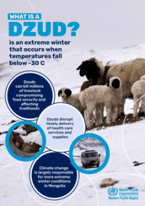
● A ‘dzud’ is a cold-season disaster in which anomalous climatic (i.e. heavy snow and severe cold) and/or land-surface (snow/ ice cover and lack of pasture) conditions lead to reduced accessibility and/or availability of forage/pastures, and ultimately to high livestock mortality during winter–spring.
● It is mainly a phenomenon in steppe, semi-desert and desert regions in Mongolia and Central Asia in which large numbers of livestock die being unable to graze due to particularly severe climatic conditions.
● Consequences: It can last all year round and can cause mass livestock mortality and dramatic socioeconomic impacts – including unemployment, poverty, and mass migration from rural to urban areas, giving rise to heavy pressure on infrastructure and social and ecosystem services.
● According to the UN Economic and Social Commission for Asia and the Pacific (ESCAP), the frequency and intensity of dzuds have increased since 2015 due to worsening climate change impacts and poor environmental governance.


 Incorrect
Answer: A
Explanation:
● A ‘dzud’ is a cold-season disaster in which anomalous climatic (i.e. heavy snow and severe cold) and/or land-surface (snow/ ice cover and lack of pasture) conditions lead to reduced accessibility and/or availability of forage/pastures, and ultimately to high livestock mortality during winter–spring.
● It is mainly a phenomenon in steppe, semi-desert and desert regions in Mongolia and Central Asia in which large numbers of livestock die being unable to graze due to particularly severe climatic conditions.
● Consequences: It can last all year round and can cause mass livestock mortality and dramatic socioeconomic impacts – including unemployment, poverty, and mass migration from rural to urban areas, giving rise to heavy pressure on infrastructure and social and ecosystem services.
● According to the UN Economic and Social Commission for Asia and the Pacific (ESCAP), the frequency and intensity of dzuds have increased since 2015 due to worsening climate change impacts and poor environmental governance.


