TAG: GS 1: GEOGRAPHY
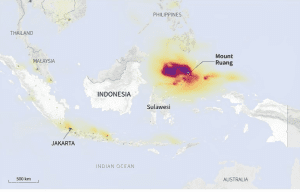
THE CONTEXT: Indonesia’s Ruang volcano, located approximately 100 km from the provincial capital of Manado, erupted once again, unleashing “explosive” flows of incandescent lava into the night sky.
EXPLANATION:
- The eruption, which occurred recently, led to a dramatic increase in volcanic activity, prompting authorities to elevate the alert status to its highest level.
- The eruption of Ruang volcano recently was characterized by the spewing of incandescent lava and rocks into the air, illuminated by flashes of lightning within the crater.
- Footage shared by Indonesia’s disaster mitigation agency captured the intensity of the eruption, with fiery red clouds billowing from the crater and lava raining down on the surrounding area.
- The eruption column reached a height of 2 km, indicating the significant magnitude of the event.
- In response to the eruption, the Center for Volcanology and Geological Hazard Mitigation raised the alert status to the highest level, urging residents within a 6-km radius to evacuate immediately.
- The spike in seismic activity, particularly deep volcanic earthquakes, further underscored the urgency of the situation.
- The authorities emphasized the potential for further “explosive eruptions,” necessitating swift evacuation measures to ensure public safety.
Impact on Infrastructure and Communities:
- The eruption forced the closure of Sam Ratulangi airport in Manado due to the potential spread of volcanic ash, disrupting air travel in the region.
- This closure is reminiscent of similar actions taken earlier in the month following previous eruptions.
- Additionally, the eruption caused damage to homes in the vicinity, highlighting the direct impact on local communities.
- Most notably, over 800 residents of the island of Ruang were evacuated in the wake of the recent eruptions, emphasizing the need for ongoing support and relief efforts.
Alert Status and Regional Context:
- Indonesia’s strategic location within the “Pacific Ring of Fire” exposes it to high seismic activity, with multiple tectonic plates converging in the region.
- The escalation of Ruang volcano’s alert status from level 3 to level 4 reflects the evolving nature of volcanic activity and the need for continued monitoring and preparedness.
- This event serves as a reminder of the constant threat posed by volcanic eruptions in Indonesia and the broader implications for regional safety and infrastructure.
Mount Ruang:
|
Stratovolcano comprising an island |
|
725 meters (2,379 ft) |
|
Sangihe Islands, Indonesia |
|
1808 |
|
1871 eruption led to a destructive tsunami, devastating plantations and a large village on Tagulandang |
|
April 2024 (ongoing) |


