Day-598
Quiz-summary
0 of 5 questions completed
Questions:
- 1
- 2
- 3
- 4
- 5
Information
DAILY MCQ
You have already completed the quiz before. Hence you can not start it again.
Quiz is loading...
You must sign in or sign up to start the quiz.
You have to finish following quiz, to start this quiz:
Results
0 of 5 questions answered correctly
Your time:
Time has elapsed
You have reached 0 of 0 points, (0)
Categories
- Not categorized 0%
- 1
- 2
- 3
- 4
- 5
- Answered
- Review
-
Question 1 of 5
1. Question
1. Consider the following pairs:
Ports in news – Countries
1. Haifa port – Israel
2. Duqm port – Yemen
3. Anjoun port – Seychelles
How many of the above pairs are correctly matched?Correct
Answer: A
Explanation:
Pair 1 is matched correctly:
• The Port of Haifa is the largest of Israel’s three major international seaports, the others being the Port of Ashdod, and the Port of Eilat. Its natural deep-water harbor operates all year long and serves both passenger and merchant ships.
• It has been in news due to takeover of operations of this port by Adani group of India.

Pair 2 is matched incorrectly:
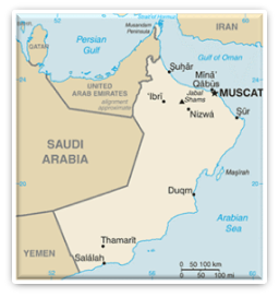
• The Port of Duqm is strategically located situated on south eastern seaboard of Oman, overlooking Arabian Sea and Indian Ocean.
• It is straddled along critical sea lanes in the Arabian Sea and Gulf of Aden.
• The Port of Duqm is strategically important for India’s maritime strategy in the Indian Ocean. It offers India access to the Gulf of Oman, the Red Sea, the Indian Ocean, and the Arabian Sea. This location is significant as it allows India to counter China’s expanding presence in the region.
Pair 3 is matched incorrectly:
• Anjoun is an island located in Comoros.
• INS Trishul visited Port Anjouan, Comoros from 31 May to 02 June 23 as part of the Indian Navy’s long-range deployment.Incorrect
Answer: A
Explanation:
Pair 1 is matched correctly:
• The Port of Haifa is the largest of Israel’s three major international seaports, the others being the Port of Ashdod, and the Port of Eilat. Its natural deep-water harbor operates all year long and serves both passenger and merchant ships.
• It has been in news due to takeover of operations of this port by Adani group of India.

Pair 2 is matched incorrectly:
• The Port of Duqm is strategically located situated on south eastern seaboard of Oman, overlooking Arabian Sea and Indian Ocean.
• It is straddled along critical sea lanes in the Arabian Sea and Gulf of Aden.
• The Port of Duqm is strategically important for India’s maritime strategy in the Indian Ocean. It offers India access to the Gulf of Oman, the Red Sea, the Indian Ocean, and the Arabian Sea. This location is significant as it allows India to counter China’s expanding presence in the region.
Pair 3 is matched incorrectly:
• Anjoun is an island located in Comoros.
• INS Trishul visited Port Anjouan, Comoros from 31 May to 02 June 23 as part of the Indian Navy’s long-range deployment. -
Question 2 of 5
2. Question
2. With reference to drainage pattern, consider the following statements:
1. Dendritic pattern develops where the river channel follows the slope of the terrain.
2. Trellis pattern develops on a strong jointed rocky terrain.
3. A rectangular pattern develops where hard and soft rocks exist parallel to each other.
4. Radial pattern develops when the stream flows in a different direction from a central peak.
How many of the above statements are correct?Correct
Answer: B
Explanation: Statements 1 and 4 are correct.
Statement 1 is correct:
Dendritic Drainage Pattern:
• It is the most common form and resembles the branching pattern of tree roots.
• The dendritic pattern develops where the river channel follows the slope of the terrain.
• The pattern develops in areas where the rock beneath the stream has no particular structure and can be eroded equally easily in all directions.
• Tributaries join larger streams at acute angles (less than 90°).
• Examples- The rivers of the northern plains; Indus, Ganga and Brahmaputra.
Statement 2 is incorrect:
Trellis Drainage Pattern:
• Trellis drainage develops in folded topography where hard and soft rocks exist parallel to each other.
• Down-turned folds called synclines form valleys in which reside the main channel of the stream.
• Such a pattern is formed when the primary tributaries of main rivers flow parallel to each other and secondary tributaries join them at right angles.
• Examples- The rivers in the upper part of the Himalayan region; Indus, Ganga and Brahmaputra.
Statement 3 is incorrect:
Rectangular Drainage Pattern:
• The rectangular drainage pattern is found in regions that have undergone faulting.
• It develops on a strongly joined rocky terrain.
• Streams follow the path of least resistance and thus are concentrated in places where exposed rock is the weakest.
• The tributary streams make sharp bends and enter the main stream at high angles.
• Examples- Streams found in the Vindhya mountain range; Chambal, Betwa and Ken.
Statement 4 is correct:
Radial Drainage Pattern:
• The radial drainage pattern develops around a central elevated point and is common to conically shaped features such as volcanoes.
• When the rivers originate from a hill and flow in all directions, the drainage pattern is known as ‘radial’.
• Examples- The rivers originating from the Amarkantak range; Narmada and Son (tributary of Ganga).Incorrect
Answer: B
Explanation: Statements 1 and 4 are correct.
Statement 1 is correct:
Dendritic Drainage Pattern:
• It is the most common form and resembles the branching pattern of tree roots.
• The dendritic pattern develops where the river channel follows the slope of the terrain.
• The pattern develops in areas where the rock beneath the stream has no particular structure and can be eroded equally easily in all directions.
• Tributaries join larger streams at acute angles (less than 90°).
• Examples- The rivers of the northern plains; Indus, Ganga and Brahmaputra.
Statement 2 is incorrect:
Trellis Drainage Pattern:
• Trellis drainage develops in folded topography where hard and soft rocks exist parallel to each other.
• Down-turned folds called synclines form valleys in which reside the main channel of the stream.
• Such a pattern is formed when the primary tributaries of main rivers flow parallel to each other and secondary tributaries join them at right angles.
• Examples- The rivers in the upper part of the Himalayan region; Indus, Ganga and Brahmaputra.
Statement 3 is incorrect:
Rectangular Drainage Pattern:
• The rectangular drainage pattern is found in regions that have undergone faulting.
• It develops on a strongly joined rocky terrain.
• Streams follow the path of least resistance and thus are concentrated in places where exposed rock is the weakest.
• The tributary streams make sharp bends and enter the main stream at high angles.
• Examples- Streams found in the Vindhya mountain range; Chambal, Betwa and Ken.
Statement 4 is correct:
Radial Drainage Pattern:
• The radial drainage pattern develops around a central elevated point and is common to conically shaped features such as volcanoes.
• When the rivers originate from a hill and flow in all directions, the drainage pattern is known as ‘radial’.
• Examples- The rivers originating from the Amarkantak range; Narmada and Son (tributary of Ganga). -
Question 3 of 5
3. Question
3. Consider the following pairs:
Hydropower projects – Rivers associated
1. Kiru hydropower project – Chenab river
2. Shanan hydropower project – Beas river
3. Sunni hydropower project – Sutlej river
How many of the above pairs are correctly matched?Correct
Answer: B
Explanation:
Pair 1 is matched correctly:
Location:
• It is being developed over the Chenab River near the villages of Patharnakki and Kiru in Kishtwar district, Jammu and Kashmir (J&K).
• It is located between Kirthai II hydroelectric project to its upstream and Kwar hydroelectric project to its downstream.
• It is a 624MW run-of-river project.
• The project is being developed by Chenab Valley Power Projects (CVPP).
• Beneficiary States: J&K, Himachal Pradesh, Punjab, Haryana, Uttar Pradesh, Uttaranchal, Rajasthan, Union territories of Chandigarh & Delhi.
Pair 2 is matched incorrectly:
• The Shanan hydropower project is developed on the Uhl River, a tributary of the Beas River.
• It is a 110 MW power project located in Mandi district, Himachal Pradesh, India.
• It was commissioned in 1932 and is currently under the control of the Punjab Government.
Controversy around the project-
• The 99-year lease on the project is set to expire in March 2024, leading to a dispute between Himachal Pradesh and Punjab over its ownership and control.
• Himachal Pradesh has made it clear that it will not renew or extend the lease and wants the project to be handed over to the state.
• Punjab, on the other hand, is unwilling to part with the project and is prepared to pursue legal action to retain it.
Pair 3 is matched correctly:
Sunni hydropower project:
• It is a run of river project.
• It is being executed on the Sutlej in Shimla and Mandi districts of Himachal Pradesh and it would have a 71-metre-high concrete gravity dam and six generating units in its surface power house.
• The project will generate 1,382 million units annually.Incorrect
Answer: B
Explanation:
Pair 1 is matched correctly:
Location:
• It is being developed over the Chenab River near the villages of Patharnakki and Kiru in Kishtwar district, Jammu and Kashmir (J&K).
• It is located between Kirthai II hydroelectric project to its upstream and Kwar hydroelectric project to its downstream.
• It is a 624MW run-of-river project.
• The project is being developed by Chenab Valley Power Projects (CVPP).
• Beneficiary States: J&K, Himachal Pradesh, Punjab, Haryana, Uttar Pradesh, Uttaranchal, Rajasthan, Union territories of Chandigarh & Delhi.
Pair 2 is matched incorrectly:
• The Shanan hydropower project is developed on the Uhl River, a tributary of the Beas River.
• It is a 110 MW power project located in Mandi district, Himachal Pradesh, India.
• It was commissioned in 1932 and is currently under the control of the Punjab Government.
Controversy around the project-
• The 99-year lease on the project is set to expire in March 2024, leading to a dispute between Himachal Pradesh and Punjab over its ownership and control.
• Himachal Pradesh has made it clear that it will not renew or extend the lease and wants the project to be handed over to the state.
• Punjab, on the other hand, is unwilling to part with the project and is prepared to pursue legal action to retain it.
Pair 3 is matched correctly:
Sunni hydropower project:
• It is a run of river project.
• It is being executed on the Sutlej in Shimla and Mandi districts of Himachal Pradesh and it would have a 71-metre-high concrete gravity dam and six generating units in its surface power house.
• The project will generate 1,382 million units annually. -
Question 4 of 5
4. Question
4. Consider the following pairs:
Valleys in news – States/UTs
1. Pengchem valley – Arunachal Pradesh
2. Niti valley – Uttrakhand
3. Muskoh valley – Ladakh
4. Darma valley – Jammu and Kashmir
How many of the above pairs are correctly matched?Correct
Answer: C
Explanation: Only pair 4 is matched incorrectly
Pair 1 is matched correctly:
Pangchen Valley:
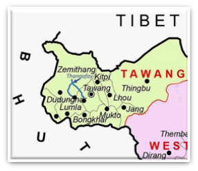
• Zemithang, the first stop of the 14th Dalai Lama during his flight from China-occupied Tibet in 1959, hosted a major Buddhist conference in April, 2023 attended by some 600 delegates, including Tibetan spiritual leaders, from across India.
• Zemithang is located in the Pangchen Valley of Arunachal Pradesh.
• It is a village and the last circle headquarters bordering Bhutan and Tibet.
• Zemithang means “sand valley” and the people of the area are referred to as Pangchenpa, meaning “people who gave up sin”.

Pair 2 is matched correctly:
Niti Valley:
• It is a remote valley located in the northernmost region of Garhwal Himalayas in Chamoli district of Uttarakhand.
• The valley’s major river is the Dhauliganga which flows south-southwest.
• Due to high altitude at Niti Valley the winter season is hard. Due to that most residents leave the Niti Valley during winter and come back in April.
• There are 24 villages in the Niti Valley. Majority of population belongs to members of the Bhotiya scheduled tribe.
• Niti, located at an elevation of 3,600 m, is the most important village of the valley.
• Nestled within the Nanda Devi Biosphere Reserve, Niti is the last village at the Indo-China border.
Pair 3 is matched correctly: The Kaobal Gali-Mushkoh Valley, which was once a battlefield during the Kargil War, has now opened up for tourists.
About Mushkoh Valley:
• It is located in Kargil’s Drass Sector of Ladakh and was a battlefield during the 1999 Kargil war between India and Pakistan.
• The region includes the Gurez Valley in north Kashmir, which was previously inaccessible to civilians due to shelling from Pakistan but now connects with the Mushkoh Valley in Kargil’s Drass Sector.
• Kaobal Gali, the highest pass at a height of 4,167 meters in Gurez, connects Gurez to Mushkoh Valley.
• The Gurez Valley is close to the Line of Control (LoC) and is also home to ibex, musk deer and marmots, Himalayan brown bear and snow leopard.
• The Kishanganga River flows through the valley.
Pair 4 is matched incorrectly:
Derma Valley:
• A snow leopard has been sighted for the first time at a height of about 11,120 feet in the Darma valley in Uttarakhand’s Pithoragarh district.Incorrect
Answer: C
Explanation: Only pair 4 is matched incorrectly
Pair 1 is matched correctly:
Pangchen Valley:
• Zemithang, the first stop of the 14th Dalai Lama during his flight from China-occupied Tibet in 1959, hosted a major Buddhist conference in April, 2023 attended by some 600 delegates, including Tibetan spiritual leaders, from across India.
• Zemithang is located in the Pangchen Valley of Arunachal Pradesh.
• It is a village and the last circle headquarters bordering Bhutan and Tibet.
• Zemithang means “sand valley” and the people of the area are referred to as Pangchenpa, meaning “people who gave up sin”.


Pair 2 is matched correctly:
Niti Valley:
• It is a remote valley located in the northernmost region of Garhwal Himalayas in Chamoli district of Uttarakhand.
• The valley’s major river is the Dhauliganga which flows south-southwest.
• Due to high altitude at Niti Valley the winter season is hard. Due to that most residents leave the Niti Valley during winter and come back in April.
• There are 24 villages in the Niti Valley. Majority of population belongs to members of the Bhotiya scheduled tribe.
• Niti, located at an elevation of 3,600 m, is the most important village of the valley.
• Nestled within the Nanda Devi Biosphere Reserve, Niti is the last village at the Indo-China border.
Pair 3 is matched correctly: The Kaobal Gali-Mushkoh Valley, which was once a battlefield during the Kargil War, has now opened up for tourists.
About Mushkoh Valley:
• It is located in Kargil’s Drass Sector of Ladakh and was a battlefield during the 1999 Kargil war between India and Pakistan.
• The region includes the Gurez Valley in north Kashmir, which was previously inaccessible to civilians due to shelling from Pakistan but now connects with the Mushkoh Valley in Kargil’s Drass Sector.
• Kaobal Gali, the highest pass at a height of 4,167 meters in Gurez, connects Gurez to Mushkoh Valley.
• The Gurez Valley is close to the Line of Control (LoC) and is also home to ibex, musk deer and marmots, Himalayan brown bear and snow leopard.
• The Kishanganga River flows through the valley.
Pair 4 is matched incorrectly:
Derma Valley:
• A snow leopard has been sighted for the first time at a height of about 11,120 feet in the Darma valley in Uttarakhand’s Pithoragarh district. -
Question 5 of 5
5. Question
5. Which of the following statements best characterizes phreatomagmatic eruptions?
Correct
Answer: B
Explanation:
Phreatomagmatic eruptions:
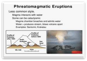
• Phreatomagmatic eruptions are volcanic events triggered by the interaction of magma with water, typically seawater.
• These interactions lead to explosive releases of ash and steam.
• The term “phreatomagmatic” combines “phreatic,” relating to water, and “magmatic,” referring to magma.
• These eruptions often occur underwater and are characterized by the explosive nature of the ash and steam release.
• A new island was born in Japan after underwater volcano eruption.


 Incorrect
Answer: B
Explanation:
Phreatomagmatic eruptions:
• Phreatomagmatic eruptions are volcanic events triggered by the interaction of magma with water, typically seawater.
• These interactions lead to explosive releases of ash and steam.
• The term “phreatomagmatic” combines “phreatic,” relating to water, and “magmatic,” referring to magma.
• These eruptions often occur underwater and are characterized by the explosive nature of the ash and steam release.
• A new island was born in Japan after underwater volcano eruption.


