THE CONTEXT: In the recent times the monsoons in India have been accompanied by the intensive cyclones. These tropical cyclones of category 2 and 3 have wind speeds between 150 and 250 kilometres per hour. The phenomenon is rare during the monsoons, but weather experts warn that such events could become normal monsoon phenomena in coming years.
RECENT CYCLONES ON INDIA’S COAST
NAME – FORMED IN – MAX WIND SPEED
Cyclone Asani (May 2022) – Bay of Bengal – 119 km/h
Cyclone Jawad (December 2021) – Bay of Bengal – 65 km/h
Cyclone Gulaab (September 2021) – Bay of Bengal – 130 km/h
Cyclone Tauktae (May 2021) – Arabian Sea – 220 km/h
Cyclone Yaas (May 2021) – Bay of Bengal – 119 km/h
Cyclone Nisarga (June 2020) – Arabian Sea – 111 km/h
Cyclone Amphan (May 2020) – Bay of Bengal – 241 km/h
TROPICAL CYCLONES IN INDIA
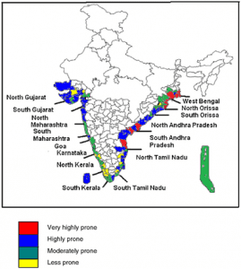
Tropical cyclones originate over the Bay of Bengal, Arabian Sea and the Indian ocean. These tropical cyclones have very high wind velocity and heavy rainfall and hit the Indian Coastal states of Tamil Nadu, Andhra Pradesh, West Bengal, Odisha and Gujarat (These five states are more vulnerable to cyclone disasters than others in India). High wind velocity and torrential rains make these cyclones highly destructive.
Elements associated with cyclones which cause destruction:
- Strong Winds/Squall: It damages installations, dwellings, communications systems, trees etc., resulting in loss of life and property.
- Torrential rains and inland flooding: Heavy rainfall is usually spread over a wide area and causes large scale soil erosion and weakening of embankments. It also brings loss of live and property to the people.
- Storm Surge: It is an abnormal rise of sea level near the coast caused by a severe tropical cyclone. Due to storm surges, sea water inundates low lying areas of coastal regions affecting human beings and livestock, causing erosion on the beaches etc.
CLIMATE CHANGE AND TROPICAL CYCLONES
- Climate change will have opposite effects on the frequency of strong tropical cyclones along the western and eastern coasts of India by 2050. The frequency will reduce in the Bay of Bengal, traditionally known for its powerful storms, while it will increase in the Arabian Sea.
- However, tropical storms that used to be formed more towards the open waters of the Bay of Bengal are likely to form in regions that lie relatively closer to the Indian and Sri Lankan coasts in the future, due to climate change. This shift is likely to cause the cyclones to make landfall sooner, shortening the time needed to intensify into Category 3 or Category 4 tropical cyclones and eastern coastal states are likely to see less intensive cyclones in the future compared to the last three decades.
- On the other hand, cyclones originating in the Arabian Sea are likely to witness the opposite effect, i.e. they are more likely to be intense.
- Microclimatic changes triggered by local climate change drivers are also contributing towards the intense cyclones. Changes include land-use-surface change, deforestation, encroachments upon wetlands and water bodies, which are contributing to this change.These factors are contributing to excessive heating of land areas. This heat is further pulled into the ocean, which is in excess of the heating of oceans due to global warming. It intensifies storms into cyclones.
MORE CYCLONES IN THE ARABIAN SEA IN THE RECENT PAST
- Sea surface temperatures in the Arabian Sea have increased rapidly during the past century due to global warming. Temp. now is 1.2–1.4 °C higher than the temperature witnessed four decades ago. These warmer temperatures support active convection, heavy rainfall, and intense cyclones. The rising temperature is also enabling the Arabian Sea to supply ample energy for the intensification of cyclones. Currently, seawater up to depths of 50 metres has been very warm that allowed Cyclone tauktae to become intense.
- Greater occurrence of El Niño Modoki. It is a climate phenomenon that means ‘pseudo El Niño’ and creates conditions that are not conducive for cyclogenesis in the Bay of Bengal. However, this condition is conducive for the formation of cyclones in the Arabian Sea. (El Nino is associated with suppressing cyclone formation in the Arabian Sea.)
THE ANALYSIS: ARE CYCLONES DURING THE MONSOON ARE THE NEW NORMAL?
- Ocean warming due to climate change is increasing the chances of cyclone formation in the Indian seas, close to the monsoon onset and withdrawal periods. However, it is hard to say yet that such cyclones are normal during the monsoons, and data from a longer period will have to be observed to see if the cyclone occurrences in monsoon become a new phenomenon.
- Scientists are of the opinion to wait at least four years more and observe the changes, but given the climate change scenario, it is likely that cyclones in monsoon could become a new normal.
Mains Practice Questions:
- India has been witnessing more number of cyclones during the monsoon season for the past few years. Elaborate on the reasons for the same?
- Climate change is having the opposite effect on the intensity and frequency of cyclones in the Arabian Sea and Bay of Bengal. Substantiate.
BACK TO BASICS
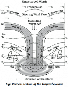
Cyclones are rapid inward air circulation around a low-pressure area. The air circulates in an anticlockwise direction in the Northern hemisphere and clockwise in the Southern hemisphere. The word Cyclone is derived from the Greek word Cyclos meaning the coils of a snake coined by Henry Paddington as the tropical storms in the Bay of Bengal and the Arabian Sea appear like coiled serpents.
FACTORS RESPONSIBLE FOR THE FORMATION AND INTENSIFICATION OF TROPICAL CYCLONES:
- Large sea surface with temperature higher than 27° C.
- Presence of the Coriolis force.
- Small variations in the vertical wind speed.
- A pre-existing weak low- pressure area or low-level-cyclonic circulation.
- Upper divergence above the sea level system.
COMPARISON OF TROPICAL AND EXTRA-TROPICAL CYCLONES:
Basis – Tropical Cyclone – Extra-tropical Cyclone
Characteristics
• A low-pressure centre
• A closed low-level atmospheric circulation
• Strong winds, and a spiral arrangement of thunderstorms that produce heavy rain.
• A large scale low-pressure weather systems that occur in the middle latitudes of the Earth.
Formation
• It gets intensified over warm tropical oceans and required temperature higher than 27° C.
• Presence of the Coriolis force, small variations in the vertical wind speed, a pre-existing weak low- pressure area or low-level-cyclonic circulation and upper divergent above the sea level system.
• It gets intensified any part of extratropical regions of the Earth (usually between 30° and 60° latitude from the equator), either through cyclogenesis or extratropical transition.
Movement
• It moves from east to west.
• It moves from west to east.
Nature of Cyclone
• Violent storms
• Static, not violent
Type
• Warm Core
• Cold Core
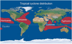
TROPICAL CYCLONE DISTRIBUTION AROUND THE WORLD:
CYCLONE PRONE REGIONS IN INDIA:
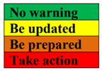
COLOR CODED WEATHER WARNING: Issued by the IMD, its objective is to alert people ahead of severe or hazardous weather event which has the potential to cause damage, widespread disruption or loss of life and property. Warnings are updated daily. The IMD uses 4 colour codes are:
- Green (All is well): No advisory is issued.
- Yellow (Be Aware): Yellow indicates severely bad weather spanning across several days. It also suggests that the weather could change for the worse, causing disruption in day-to-day activities.
- Orange/Amber (Be prepared): The orange alert is issued as a warning of extremely bad weather with the potential of disruption in commute with road and rail closures, and interruption of power supply.
- Red (Take Action): When the extremely bad weather conditions are certainly going to disrupt travel and power and have significant risk to life, the red alert is issued.
WHY EASTERN COAST OF INDIA IS MORE VULNERABLE TO CYCLONES:
With a coastline of 7517 km, India is exposed to nearly 10 per cent of the world’s tropical cyclones. Although cyclones affect the entire coast of India, the eastern coast is significantly more prone to cyclones as compared to the western coast.
According to National Cyclone Risk Mitigation Project (NCRMP) data, about 58 percent of the cyclones that are formed in the Bay of Bengal hit and cross the eastern coast while only 25 percent of the cyclones developing in the Arabian Sea are seen approaching the western coast of India.
Reasons for more number of cyclones in the Bay of Bengal:
- Since sea surface temperatures and humidity both directly correlate with chances of cyclone formation, the Bay of Bengal is a more likely target because it gets higher rainfall. The sluggish winds around it keep temperatures relatively high: about 28 degrees around the year. Warm air currents enhance this surface temperature and aid the formation of cyclones.
- In addition, the Bay receives higher rainfall and constant inflow of freshwater from the Ganga and Brahmaputra rivers. This means that the Bay’s surface water keeps getting refreshed, making it impossible for the warm water to mix with the cooler water below, making it ideal for depression. On the other hand, the Arabian Sea receives stronger winds that help dissipate the heat, and the lack of constant freshwater supply helps the warm water mix with the cool water, reducing the temperature.
- But not all cyclones are formed in the Bay of Bengal. The basin is also host to cyclones formed elsewhere but move towards the water body, especially those formed in the Pacific Ocean. Cyclones usually weaken if they encounter a large landmass. However, due to the lack of any such presence between the Pacific and the Bay, cyclonic winds easily move into the Bay of Bengal. Once here, the winds encounter the Western Ghats and the Himalayas, either becoming weak or getting blocked in the Bay but never reaching the Arabian Sea.
