Day-758
Quiz-summary
0 of 20 questions completed
Questions:
- 1
- 2
- 3
- 4
- 5
- 6
- 7
- 8
- 9
- 10
- 11
- 12
- 13
- 14
- 15
- 16
- 17
- 18
- 19
- 20
Information
DAILY MCQ
You have already completed the quiz before. Hence you can not start it again.
Quiz is loading...
You must sign in or sign up to start the quiz.
You have to finish following quiz, to start this quiz:
Results
0 of 20 questions answered correctly
Your time:
Time has elapsed
You have reached 0 of 0 points, (0)
Categories
- Not categorized 0%
- 1
- 2
- 3
- 4
- 5
- 6
- 7
- 8
- 9
- 10
- 11
- 12
- 13
- 14
- 15
- 16
- 17
- 18
- 19
- 20
- Answered
- Review
-
Question 1 of 20
1. Question
Consider the following statements:
1. Dhauli Ganga and Trishul Ganga are the tributaries of river Alaknanda.
2. Dhauli Ganga and Vishnu Ganga meet each other at Karna Prayag.
Which of the statements given above is/are correct?Correct
Answer. D
Explanation-
Statement 1 is incorrect- Dhauli Ganga and Vishnu Ganga are tributaries of river Akaknanda. Trishul Ganga is a tributary of river Gandak.
Statement 2 is incorrect- The Alaknanda consists of Dhauli Ganga and Vishnu Ganga which meet at Joshimath or Vishnu Prayag.
The other tributaries of Alaknanda such as Pindar meet it at Karna Prayag while Mandakini or Kali Ganga joins it at Rudra Prayag.
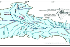
Additional information:
● Devprayag: where Alaknanda meets Bhagirathi
● Rudraprayag: where Alaknanda meets Mandakini
● Karnaprayag: where Alaknanda meets Pinder
● Nandprayag: where Alaknanda meets Nandakini
● Vishnuprayag: where Alaknanda meets Dhauli GangaIncorrect
Answer. D
Explanation-
Statement 1 is incorrect- Dhauli Ganga and Vishnu Ganga are tributaries of river Akaknanda. Trishul Ganga is a tributary of river Gandak.
Statement 2 is incorrect- The Alaknanda consists of Dhauli Ganga and Vishnu Ganga which meet at Joshimath or Vishnu Prayag.
The other tributaries of Alaknanda such as Pindar meet it at Karna Prayag while Mandakini or Kali Ganga joins it at Rudra Prayag.

Additional information:
● Devprayag: where Alaknanda meets Bhagirathi
● Rudraprayag: where Alaknanda meets Mandakini
● Karnaprayag: where Alaknanda meets Pinder
● Nandprayag: where Alaknanda meets Nandakini
● Vishnuprayag: where Alaknanda meets Dhauli Ganga -
Question 2 of 20
2. Question
Which one of the following elements is present in the least quantity in the Earth’s crust?
Correct
Answer. C
Explanation- About 98% of the total crust of the earth is composed of eight elements like oxygen, silicon, aluminium, iron, calcium, sodium, potassium and magnesium while the rest is constituted by titanium, hydrogen, phosphorus, manganese, sulphur, carbon, nickel and other elements.
Table: Major Elements of the Earth’s Crust
 Incorrect
Answer. C
Explanation- About 98% of the total crust of the earth is composed of eight elements like oxygen, silicon, aluminium, iron, calcium, sodium, potassium and magnesium while the rest is constituted by titanium, hydrogen, phosphorus, manganese, sulphur, carbon, nickel and other elements.
Table: Major Elements of the Earth’s Crust


-
Question 3 of 20
3. Question
Consider the following statements:
Statement I- The soils in the tundra region show a thin profile in comparison to tropical soils.
Statement II- Chemical and biological activities take place at a slower pace in cooler temperatures.
Which of the following is correct in respect of the above statements?Correct
Answer. A
Explanation-
Statement 1 is correct- The soil profile of the frozen tundra region is thinner in comparison to the tropical soils. The tropical soils with higher temperatures show deeper soil profiles and in frozen tundra regions, the soils contain largely mechanically broken materials.
Statement 2 is correct- Chemical and biological activities take place at a slower pace in cooler temperatures.
Temperature acts in two ways: increasing or reducing chemical and biological activity. Chemical activity is increased in higher temperatures, reduced in cooler temperatures (with an exception of carbonation) and stops in freezing conditions.Incorrect
Answer. A
Explanation-
Statement 1 is correct- The soil profile of the frozen tundra region is thinner in comparison to the tropical soils. The tropical soils with higher temperatures show deeper soil profiles and in frozen tundra regions, the soils contain largely mechanically broken materials.
Statement 2 is correct- Chemical and biological activities take place at a slower pace in cooler temperatures.
Temperature acts in two ways: increasing or reducing chemical and biological activity. Chemical activity is increased in higher temperatures, reduced in cooler temperatures (with an exception of carbonation) and stops in freezing conditions. -
Question 4 of 20
4. Question
In the context of composition of the atmosphere, consider the following:
1. Hydrogen and Helium are the dominant gases in the heterosphere.
2. Majority of the mass of the atmosphere is confined up to an altitude of 90 km from the earth’s surface.
3. The concentration of water vapour is more in desert regions.
4. The concentration of dust particles is higher in sub-tropical and temperate regions.
How many of the above statements are correct?Correct
Answer. B
Explanation- Up to an altitude of about 90 km, the composition of the atmosphere is uniform in terms of three major gases- nitrogen, oxygen and argon. This layer is called the homosphere. Above 90 km, the composition begins to change with progressive increase in the lighter gases. This layer is known as heterosphere.
Statement 1 is correct- Hydrogen and Helium are dominant gases in the heterosphere.
Note that carbon dioxide and water vapour are found only up to 90 km from the surface of the earth. Oxygen is almost in negligible quantity at the height of 120 km.
Statement 2 is incorrect- Majority (99%) of the mass of the atmosphere is confined up to an altitude of 32 km from the earth’s surface.
Statement 3 is incorrect- The concentration of water vapour is more in warm and wet tropical regions. Water vapour is a variable gas in the atmosphere which decreases with altitude. In the warm and wet tropics, it may account for 4% of the air by volume while in the dry and cold areas of desert and polar regions, it may be less than 1% of the air.
Statement 4 is correct- The concentration of dust particles is higher in sub-tropical and temperate regions due to dry winds in comparison to equatorial and polar regions.
Dust particles are generally concentrated in the lower layers of the atmosphere; yet convectional air currents may transport them to great heights.Incorrect
Answer. B
Explanation- Up to an altitude of about 90 km, the composition of the atmosphere is uniform in terms of three major gases- nitrogen, oxygen and argon. This layer is called the homosphere. Above 90 km, the composition begins to change with progressive increase in the lighter gases. This layer is known as heterosphere.
Statement 1 is correct- Hydrogen and Helium are dominant gases in the heterosphere.
Note that carbon dioxide and water vapour are found only up to 90 km from the surface of the earth. Oxygen is almost in negligible quantity at the height of 120 km.
Statement 2 is incorrect- Majority (99%) of the mass of the atmosphere is confined up to an altitude of 32 km from the earth’s surface.
Statement 3 is incorrect- The concentration of water vapour is more in warm and wet tropical regions. Water vapour is a variable gas in the atmosphere which decreases with altitude. In the warm and wet tropics, it may account for 4% of the air by volume while in the dry and cold areas of desert and polar regions, it may be less than 1% of the air.
Statement 4 is correct- The concentration of dust particles is higher in sub-tropical and temperate regions due to dry winds in comparison to equatorial and polar regions.
Dust particles are generally concentrated in the lower layers of the atmosphere; yet convectional air currents may transport them to great heights. -
Question 5 of 20
5. Question
In the context of sunspot activity, consider the following statements:
1. Sunspots are darker and hotter patches on the sun.
2. An increase in the sunspot activity causes warm and drier conditions.
Which of the statements given above is/are correct?Correct
Answer. D
Explanation- The causes for climate change can be grouped into astronomical and terrestrial causes. The astronomical causes are the changes in solar output associated with sunspot activities.
Statement 1 is incorrect- Sunspots are dark and cooler patches on the sun which increase and decrease in a cyclical manner.
Statement 2 is incorrect- According to meteorologists, a decrease in sunspot activity is associated with warm and drier conditions whereas cooler and wetter weather conditions are an aftermath of increase in sunspot numbers.Incorrect
Answer. D
Explanation- The causes for climate change can be grouped into astronomical and terrestrial causes. The astronomical causes are the changes in solar output associated with sunspot activities.
Statement 1 is incorrect- Sunspots are dark and cooler patches on the sun which increase and decrease in a cyclical manner.
Statement 2 is incorrect- According to meteorologists, a decrease in sunspot activity is associated with warm and drier conditions whereas cooler and wetter weather conditions are an aftermath of increase in sunspot numbers. -
Question 6 of 20
6. Question
In the context of ocean bottom topography, which of the following statements is correct?
Correct
Answer. C
Explanation- The ocean floor can be divided into four major divisions: continental shelf, continental slope, deep sea plain and oceanic deeps. Besides these divisions, there are also major and minor relief features in the ocean floors like ridges, hills, sea mounts, guyots, trenches, canyons etc.
Statement 1 is incorrect- Shelf break demarcates the boundary between continental shelf and continental slope.
The continental shelf is the shallowest part of the ocean having an average gradient of 1 degree or less. The shelf typically ends at a very steep slope, called the shelf break.
Statement 2 is incorrect- The continental shelves are absent or very narrow along some of the margins like the coasts of Chile and west coast of Sumatra etc.
On the contrary, the Siberian shelf in the Arctic Ocean is the largest in the world and extends up to 1500 km.
Statement 3 is correct- Trenches on continental slope are associated with volcanic activity. The ocean deeps or trenches are the deepest parts of the ocean which are relatively steep-sided, narrow basins. They are some 3-5 km deeper than the surrounding ocean floor.
They occur at the bases of continental slopes and along island arcs and are associated with active volcanoes and earthquakes. That is why they are significant in the study of plate tectonics.
Statement 4 is incorrect- The Pacific Ocean has the highest number of trenches (32) followed by the Atlantic Ocean (19) and the Indian ocean (6).Incorrect
Answer. C
Explanation- The ocean floor can be divided into four major divisions: continental shelf, continental slope, deep sea plain and oceanic deeps. Besides these divisions, there are also major and minor relief features in the ocean floors like ridges, hills, sea mounts, guyots, trenches, canyons etc.
Statement 1 is incorrect- Shelf break demarcates the boundary between continental shelf and continental slope.
The continental shelf is the shallowest part of the ocean having an average gradient of 1 degree or less. The shelf typically ends at a very steep slope, called the shelf break.
Statement 2 is incorrect- The continental shelves are absent or very narrow along some of the margins like the coasts of Chile and west coast of Sumatra etc.
On the contrary, the Siberian shelf in the Arctic Ocean is the largest in the world and extends up to 1500 km.
Statement 3 is correct- Trenches on continental slope are associated with volcanic activity. The ocean deeps or trenches are the deepest parts of the ocean which are relatively steep-sided, narrow basins. They are some 3-5 km deeper than the surrounding ocean floor.
They occur at the bases of continental slopes and along island arcs and are associated with active volcanoes and earthquakes. That is why they are significant in the study of plate tectonics.
Statement 4 is incorrect- The Pacific Ocean has the highest number of trenches (32) followed by the Atlantic Ocean (19) and the Indian ocean (6). -
Question 7 of 20
7. Question
Consider the following statements:
1. The Red Sea records salinity levels lower than the Baltic Sea.
2. Equatorial waters have salinity levels less than the average salinity of oceans.
Which of the statements given above is/are correct?Correct
Answer. B
Explanation-
Statement 1 is incorrect- Red Sea has salinity higher than the Baltic Sea.
Salinity of the Red Sea is around 39 ppt whereas the Baltic Sea has an average salinity of about 7 ppt.
The higher salinity of the Red Sea is attributed to the higher levels of evaporation and minimal addition of freshwater by rivers which are fewer in number. In contrast to this, the influx of freshwater through numerous rivers takes place in the Baltic Sea which dilutes the salinity in the water.
Statement 2 is correct- Salinity is lower than the average 35 ppt in equatorial waters because of the heavy rainfall and high relative humidity.Incorrect
Answer. B
Explanation-
Statement 1 is incorrect- Red Sea has salinity higher than the Baltic Sea.
Salinity of the Red Sea is around 39 ppt whereas the Baltic Sea has an average salinity of about 7 ppt.
The higher salinity of the Red Sea is attributed to the higher levels of evaporation and minimal addition of freshwater by rivers which are fewer in number. In contrast to this, the influx of freshwater through numerous rivers takes place in the Baltic Sea which dilutes the salinity in the water.
Statement 2 is correct- Salinity is lower than the average 35 ppt in equatorial waters because of the heavy rainfall and high relative humidity. -
Question 8 of 20
8. Question
Consider the following statements regarding movement of ocean currents:
1. Equatorial current flows from west to east.
2. The west wind drift flows from the east to west.
3. Benguela current flows along the east coast of Africa.
How many of the above statements are incorrect?Correct
Answer. C
Explanation- Ocean currents are river-like flows in oceans which represent a regular volume of water in a definite path and direction. Major ocean currents are greatly influenced by the stresses exerted by the prevailing winds and Coriolis force.
The genesis of equatorial and counter-equatorial ocean currents is due to the rotation of the earth which influences their direction of flow as well.
Statement 1 is incorrect- The Equatorial current flows from east to west while the equatorial counter current flows from west to east.
Statement 2 is incorrect- The west wind drift flows from west to east under the influence of westerlies. It is the largest ocean current in the world which is alternatively called Antarctic circumpolar current. It is responsible for transporting enormous volumes of cold, nutrient-rich water to the ocean, creating healthy marine ecosystems and food webs.
Statement 3 is incorrect- Benguela current flows along the south-western coast of Africa, off the Cape of Good Hope. It is a cold ocean current.
The Benguela Current is the eastern boundary current of the South Atlantic subtropical gyre. The Benguela Current flows through a strong, biologically productive upwelling region, and advects cool waters to the tropics.Incorrect
Answer. C
Explanation- Ocean currents are river-like flows in oceans which represent a regular volume of water in a definite path and direction. Major ocean currents are greatly influenced by the stresses exerted by the prevailing winds and Coriolis force.
The genesis of equatorial and counter-equatorial ocean currents is due to the rotation of the earth which influences their direction of flow as well.
Statement 1 is incorrect- The Equatorial current flows from east to west while the equatorial counter current flows from west to east.
Statement 2 is incorrect- The west wind drift flows from west to east under the influence of westerlies. It is the largest ocean current in the world which is alternatively called Antarctic circumpolar current. It is responsible for transporting enormous volumes of cold, nutrient-rich water to the ocean, creating healthy marine ecosystems and food webs.
Statement 3 is incorrect- Benguela current flows along the south-western coast of Africa, off the Cape of Good Hope. It is a cold ocean current.
The Benguela Current is the eastern boundary current of the South Atlantic subtropical gyre. The Benguela Current flows through a strong, biologically productive upwelling region, and advects cool waters to the tropics. -
Question 9 of 20
9. Question
In the context of river Brahmaputra, consider the following statements:
1. Brahmaputra is known as Singhi Khamban in Tibet.
2. Dibang and Lohit are the main left bank tributaries of Brahmaputra.
3. Kameng, Sankosh and Subansiri are the right bank tributaries of Brahmaputra.
Which of the statements given above is/are correct?Correct
Answer. C
Explanation- The Brahmaputra, one of the largest rivers of the world, has its origins in the Trans-Himalayan glacier of the Kailash range near Mansarovar lake; from there it traverses eastwards longitudinally for a distance of 1200 km in a dry and flat region of southern Tibet as the Tsangpo, which means purifier.
Statement 1 is incorrect- Brahmaputra is known as the ‘Tsang Po’ in Tibet and Jamuna in Bangladesh.
The Indus River is known as ‘Singhi Khamban’ in Tibet.
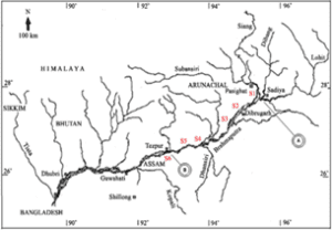
Statement 2 is correct- Brahmaputra enters India west of Sadiya town in Arunachal Pradesh. Flowing southwest, it receives its main left bank tributaries viz. Dibang and Lohit, thereafter it is known as the Brahmaputra.
Statement 3 is correct- The Brahmaputra receives numerous tributaries in its 750 km long journey in the Assam valley. The major left bank tributaries are the Burhi Dihing, Dhansiri and Kalang whereas the important right bank tributaries are the Subansiri (which rises in the Tibet Himalayas), Kamang, Manas and Sankosh.
It flows into Bangladesh near Dubari and flows southward.


 Incorrect
Answer. C
Explanation- The Brahmaputra, one of the largest rivers of the world, has its origins in the Trans-Himalayan glacier of the Kailash range near Mansarovar lake; from there it traverses eastwards longitudinally for a distance of 1200 km in a dry and flat region of southern Tibet as the Tsangpo, which means purifier.
Statement 1 is incorrect- Brahmaputra is known as the ‘Tsang Po’ in Tibet and Jamuna in Bangladesh.
The Indus River is known as ‘Singhi Khamban’ in Tibet.
Statement 2 is correct- Brahmaputra enters India west of Sadiya town in Arunachal Pradesh. Flowing southwest, it receives its main left bank tributaries viz. Dibang and Lohit, thereafter it is known as the Brahmaputra.
Statement 3 is correct- The Brahmaputra receives numerous tributaries in its 750 km long journey in the Assam valley. The major left bank tributaries are the Burhi Dihing, Dhansiri and Kalang whereas the important right bank tributaries are the Subansiri (which rises in the Tibet Himalayas), Kamang, Manas and Sankosh.
It flows into Bangladesh near Dubari and flows southward.


-
Question 10 of 20
10. Question
Read the following description given below:
“Known as Vridha Ganga, this river has its source in Nasik district of Maharashtra. The principal tributaries include Manjira, Penganga and Wainganga.”
Which of the following rivers is being described above?Correct
Answer. D
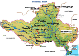
Explanation- Godavari is the largest Peninsular river system. It is also called Dakshin Ganga or Vridha Ganga because of its location, age, size and length. It rises in the Nasik district of Maharashtra and discharges in the Bay Of Bengal. Its tributaries run through the states of Maharashtra, Madhya Pradesh , Chattisgarh, Odisha and Andhra Pradesh.
Its principal tributaries are:
● Penganga
● Wainganga
● Pranhita
● Sabari
● Wardha
● Manjira


 Incorrect
Answer. D
Explanation- Godavari is the largest Peninsular river system. It is also called Dakshin Ganga or Vridha Ganga because of its location, age, size and length. It rises in the Nasik district of Maharashtra and discharges in the Bay Of Bengal. Its tributaries run through the states of Maharashtra, Madhya Pradesh , Chattisgarh, Odisha and Andhra Pradesh.
Its principal tributaries are:
● Penganga
● Wainganga
● Pranhita
● Sabari
● Wardha
● Manjira


-
Question 11 of 20
11. Question
The Tamil Nadu coast remains dry during the summer months. Consider the following reasons in this context:
1. It is located in the rainshadow zone of the Bay of Bengal branch of the southwest monsoon.
2. It is located in the rainshadow zone of the Arabian sea branch of the southwest monsoon.
3. It is under the influence of the retreating monsoon.
4. Its coast lies parallel to the Bay of Bengal branch of southwest monsoon.
How many of the above factors correctly explain the reason behind the absence of rainfall in the Tamil Nadu coast in summers?Correct
Answer. B
Explanation- The Tamil Nadu coast remains dry during the summer season. There are two factors responsible for it:
(i) The Tamil Nadu coast is situated parallel to the Bay of Bengal branch of southwest monsoon.
(ii) It lies in the rainshadow area of the Arabian Sea branch of the south-west monsoon
Therefore, factors 2 and 4 are correct.Incorrect
Answer. B
Explanation- The Tamil Nadu coast remains dry during the summer season. There are two factors responsible for it:
(i) The Tamil Nadu coast is situated parallel to the Bay of Bengal branch of southwest monsoon.
(ii) It lies in the rainshadow area of the Arabian Sea branch of the south-west monsoon
Therefore, factors 2 and 4 are correct. -
Question 12 of 20
12. Question
Consider the following statements about the river Vaitarna:
1. Vaitarna is an east-flowing river.
2. It originates from the Western Ghats.
Which of the statements given above is/are correct?Correct
Answer. B
Explanation- The coastal rivers flow to the west into the Arabian sea and to the east into the Bay of Bengal. Among the small west-flowing rivers of Peninsular India is river Vaitarna.
Statement 1 is incorrect- Vaitarna is a west-flowing river in the region of Mumbai and south of the river Tapi.


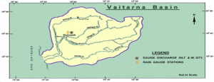
Statement 2 is correct- The river Vaitarna rises in the Sahyadri hill range at Trimbak in the Nasik district of Maharashtra. After traversing a distance of about 120 km in Maharashtra towards west, it joins the Arabian Sea.Incorrect
Answer. B
Explanation- The coastal rivers flow to the west into the Arabian sea and to the east into the Bay of Bengal. Among the small west-flowing rivers of Peninsular India is river Vaitarna.
Statement 1 is incorrect- Vaitarna is a west-flowing river in the region of Mumbai and south of the river Tapi.


Statement 2 is correct- The river Vaitarna rises in the Sahyadri hill range at Trimbak in the Nasik district of Maharashtra. After traversing a distance of about 120 km in Maharashtra towards west, it joins the Arabian Sea. -
Question 13 of 20
13. Question
Consider the following statements regarding the retreating monsoon in India:
1. Oppressive weather with high humidity and temperature marks the October Heat.
2. The Inter-Tropical Convergence Zone (ITCZ) shifts southward from the previous position in Ganga plains.
3. Intense tropical cyclones are witnessed in the Arabian sea.
4. There is enough rainfall in North India.
How many of the above statements are correct?Correct
Answer. B
Explanation- The months of October and November are known for retreating monsoons.
Statement 1 is correct- The retreating southwest monsoon season is marked by clear skies and rise in temperature. The land is still moist. Owing to the conditions of high temperature and humidity, the weather becomes rather oppressive. This is commonly known as the ‘October heat’.
Statement 2 is correct- By the end of September, the southwest monsoon becomes weak as the low pressure trough of the Ganga plain starts moving southward in response to the southward march of the sun.
The monsoon retreats from the western Rajasthan by the first week of September. It withdraws from Rajasthan, Gujarat, Western Ganga plain and the Central Highlands by the end of the month. By the beginning of October, the low pressure covers northern parts of the Bay of Bengal and by early November, it moves over Karnataka and Tamil Nadu. By the middle of December, the centre of low pressure is completely removed from the Peninsula.
Statement 3 is incorrect- Intense tropical cyclones are witnessed in the northern part of Bay of Bengal since the centre of low pressure moves southward from the Ganga plains and Central Highlands towards north Bay of Bengal region which creates conducive conditions for cyclogenesis. Tropical cyclones develop in response and cause heavy rainfall in the eastern peninsular India.
Statement 4 is incorrect- The weather in the retreating monsoon is dry in north India but it is associated with rain in the eastern part of the Peninsula. Here, October and November are the rainiest months of the year.Incorrect
Answer. B
Explanation- The months of October and November are known for retreating monsoons.
Statement 1 is correct- The retreating southwest monsoon season is marked by clear skies and rise in temperature. The land is still moist. Owing to the conditions of high temperature and humidity, the weather becomes rather oppressive. This is commonly known as the ‘October heat’.
Statement 2 is correct- By the end of September, the southwest monsoon becomes weak as the low pressure trough of the Ganga plain starts moving southward in response to the southward march of the sun.
The monsoon retreats from the western Rajasthan by the first week of September. It withdraws from Rajasthan, Gujarat, Western Ganga plain and the Central Highlands by the end of the month. By the beginning of October, the low pressure covers northern parts of the Bay of Bengal and by early November, it moves over Karnataka and Tamil Nadu. By the middle of December, the centre of low pressure is completely removed from the Peninsula.
Statement 3 is incorrect- Intense tropical cyclones are witnessed in the northern part of Bay of Bengal since the centre of low pressure moves southward from the Ganga plains and Central Highlands towards north Bay of Bengal region which creates conducive conditions for cyclogenesis. Tropical cyclones develop in response and cause heavy rainfall in the eastern peninsular India.
Statement 4 is incorrect- The weather in the retreating monsoon is dry in north India but it is associated with rain in the eastern part of the Peninsula. Here, October and November are the rainiest months of the year. -
Question 14 of 20
14. Question
Consider the following description:
“Characterised by grasslands such as Llanos, Campos and Kano, this climate has the most distinct dry and wet seasons. It comes under the influence of trade winds and local winds like Harmatton. The grass is tall and coarse. The tribes like Masai are known to keep zebu cattle which are kept entirely for the supply of milk and blood.”
Identify the type of climate based on the description given above:Correct
Answer. B
Explanation- SAVANNA OR SUDAN-TYPE CLIMATE


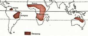
● Transitional climate between equatorial forests and trade wind hot deserts.
● Confined within tropics and best developed in Sudan.
● Distinct wet and dry seasons.
● Extreme diurnal range of temperature.
● Trade winds prevail in the region and bring rains to the coastal areas.
● In West Africa, the North-East trades are offshore and reach the Guinea coast as dry, dust-laden wind called Harmatton (doctor winds).
● Tall, coarse grass interspersed with short trees dominates the vegetation here.
● Human life- Tribes like Masai inhabit countries like Kenya, Tanzania and Uganda. They are cattle pastoralists.
Hausa are a tribe of settled cultivators inhabiting Nigeria. They grow crops such as maize, groundnuts, bananas, beans, cotton and tobacco.
● Zebu Cattle are kept by Masai tribes as symbol of wealth which are never used as draught animals but used for supply of milk and blood.
● Diseases- Ngana or sleeping sickness is spread by tsetse fly in Africa.Incorrect
Answer. B
Explanation- SAVANNA OR SUDAN-TYPE CLIMATE


● Transitional climate between equatorial forests and trade wind hot deserts.
● Confined within tropics and best developed in Sudan.
● Distinct wet and dry seasons.
● Extreme diurnal range of temperature.
● Trade winds prevail in the region and bring rains to the coastal areas.
● In West Africa, the North-East trades are offshore and reach the Guinea coast as dry, dust-laden wind called Harmatton (doctor winds).
● Tall, coarse grass interspersed with short trees dominates the vegetation here.
● Human life- Tribes like Masai inhabit countries like Kenya, Tanzania and Uganda. They are cattle pastoralists.
Hausa are a tribe of settled cultivators inhabiting Nigeria. They grow crops such as maize, groundnuts, bananas, beans, cotton and tobacco.
● Zebu Cattle are kept by Masai tribes as symbol of wealth which are never used as draught animals but used for supply of milk and blood.
● Diseases- Ngana or sleeping sickness is spread by tsetse fly in Africa. -
Question 15 of 20
15. Question
Consider the following statements:
Statement I- Rainfall is evenly distributed in British Columbia and London throughout the year.
Statement II- The western part of cool temperate regions is affected by the westerlies and temperate cyclones.
Which of the following is correct in respect of the above statements?Correct
Answer. A
Explanation-
Statement 1 is correct- Rainfall is evenly distributed in regions having British type climate such as British Colombia, London, Southern Chile, Tasmania, and most parts of New Zealand.
Such a climate typifies moderate summer and abnormally mild winters making the climate ideal for mental alertness.


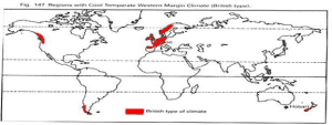
Statement 2 is correct and also explains statement 1 aptly- The western part of cool temperate regions is affected by westerlies and temperate cyclones. Frontal cyclogenesis is common in such regions.
The British type climate has adequate rainfall throughout the year with a tendency towards slight winter or autumn maximum from cyclonic sources. Since the rain-bearing winds come from the west, the western margins have the heaviest rainfall.Incorrect
Answer. A
Explanation-
Statement 1 is correct- Rainfall is evenly distributed in regions having British type climate such as British Colombia, London, Southern Chile, Tasmania, and most parts of New Zealand.
Such a climate typifies moderate summer and abnormally mild winters making the climate ideal for mental alertness.


Statement 2 is correct and also explains statement 1 aptly- The western part of cool temperate regions is affected by westerlies and temperate cyclones. Frontal cyclogenesis is common in such regions.
The British type climate has adequate rainfall throughout the year with a tendency towards slight winter or autumn maximum from cyclonic sources. Since the rain-bearing winds come from the west, the western margins have the heaviest rainfall. -
Question 16 of 20
16. Question
Consider the following statements:
1. Sirocco is a hot, moist wind which affects southern Europe.
2. Mistral blows from the Atlas Mountains towards France.
Which of the statements given above is/are correct?Correct
Answer. A
Explanation-
Statement 1 is correct- Sirocco is a warm and humid local wind which originates from the Sahara and blows towards the Mediterranean Sea and southern Europe.
It originates from Northern parts of Africa as dry wind but picks moisture from the Mediterranean Sea and causes blood rain in southern parts of European countries like Spain. The rainfall caused is called blood rain because of the red dust which the winds pick from the Sahara Desert.
Statement 2 is incorrect- Mistral is a local cold wind which originates over the snow-capped mountains of the Alps and blows towards France and the Mediterranean Sea. It is channelled through the Rhone valley. It is a very cold and dry wind with high velocity.Incorrect
Answer. A
Explanation-
Statement 1 is correct- Sirocco is a warm and humid local wind which originates from the Sahara and blows towards the Mediterranean Sea and southern Europe.
It originates from Northern parts of Africa as dry wind but picks moisture from the Mediterranean Sea and causes blood rain in southern parts of European countries like Spain. The rainfall caused is called blood rain because of the red dust which the winds pick from the Sahara Desert.
Statement 2 is incorrect- Mistral is a local cold wind which originates over the snow-capped mountains of the Alps and blows towards France and the Mediterranean Sea. It is channelled through the Rhone valley. It is a very cold and dry wind with high velocity. -
Question 17 of 20
17. Question
Consider the following statements:
Statement I – Satellites are placed ideally in the exosphere.
Statement II- Hydrogen and Helium gases are found in the uppermost layer of the atmosphere.
Which of the following is correct in respect of the above statements?Correct
Answer. B
Explanation-
Statement 1 is correct- The High Earth Orbit and Mid-earth Orbit Satellites are placed ideally in the exosphere or thermosphere.
Statement 2 is correct but does not provide explanation of statement 1- With the rise in altitude from the surface of the earth, the lighter gases such as Hydrogen and Helium increase in concentration.
However, the reason behind placing satellites in the exosphere is concerned with the thickness of the atmosphere and resistance caused. There is absence of friction in the upper layers of the atmosphere since the air in the upper atmosphere is thin. This does not hinder the movement of satellites in orbits.Incorrect
Answer. B
Explanation-
Statement 1 is correct- The High Earth Orbit and Mid-earth Orbit Satellites are placed ideally in the exosphere or thermosphere.
Statement 2 is correct but does not provide explanation of statement 1- With the rise in altitude from the surface of the earth, the lighter gases such as Hydrogen and Helium increase in concentration.
However, the reason behind placing satellites in the exosphere is concerned with the thickness of the atmosphere and resistance caused. There is absence of friction in the upper layers of the atmosphere since the air in the upper atmosphere is thin. This does not hinder the movement of satellites in orbits. -
Question 18 of 20
18. Question
Consider the following countries:
1. Ghana
2. Mali
3. Nigeria
4. Burkina Faso
How many of the above countries are part of the Sahel Region of Africa?Correct
Answer. C
Context- Burkina Faso has been in news due to the internal displacement of more than 2 million people because of violence at hands of terror groups like Al Qaeda and Islamic State.
Nigeria has been in limelight for inter-communal violence that often causes the bloodshed in this country.
Explanation- Sahel region in Africa can be defined as an ecoclimatic and biogeographic realm marked by transition between the Sahara on the North and Sudan/Savanna on the South.
The region has been suffering due to rising extremism and violence.
Largely, the Sahel region is characterised by semi-arid climate and comprises of the following countries (as per UN and IFAD)-


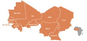
i. Mauritania
ii. Senegal
iii. Gambia
iv. Guinea
v. Mali
vi. Burkina Faso
vii. Niger
viii. Nigeria
ix. Chad
x. CameroonIncorrect
Answer. C
Context- Burkina Faso has been in news due to the internal displacement of more than 2 million people because of violence at hands of terror groups like Al Qaeda and Islamic State.
Nigeria has been in limelight for inter-communal violence that often causes the bloodshed in this country.
Explanation- Sahel region in Africa can be defined as an ecoclimatic and biogeographic realm marked by transition between the Sahara on the North and Sudan/Savanna on the South.
The region has been suffering due to rising extremism and violence.
Largely, the Sahel region is characterised by semi-arid climate and comprises of the following countries (as per UN and IFAD)-


i. Mauritania
ii. Senegal
iii. Gambia
iv. Guinea
v. Mali
vi. Burkina Faso
vii. Niger
viii. Nigeria
ix. Chad
x. Cameroon -
Question 19 of 20
19. Question
Consider the following statements:
1. Typhoons are more common in the North Atlantic Ocean.
2. Hurricanes are formed over the North-West Pacific.
3. Cyclones are tropical storms developing over the Indian Ocean.
How many of the above statements are correct?Correct
Answer. A
Explanation- Tropical cyclones are violent storms originating over oceans in tropical areas which move towards the coastal areas bringing about huge devastation by violent winds, very heavy rainfall and storm surges.
They are known by different names depending on their region of origin in the world.
Statement 1 is incorrect- Typhoons are more common in Western Pacific Ocean.
Statement 2 is incorrect- Hurricanes are formed over the North Atlantic Ocean and eastern North Pacific Ocean.
Statement 3 is correct- Tropical cyclones are referred to as cyclones in the Indian Ocean and south Pacific Ocean.
Cyclone Indian ocean
Hurricane – Atlantic Ocean
Typhoons – Western Pacific Ocean and South China sea
Willy-willies – Western AustraliaIncorrect
Answer. A
Explanation- Tropical cyclones are violent storms originating over oceans in tropical areas which move towards the coastal areas bringing about huge devastation by violent winds, very heavy rainfall and storm surges.
They are known by different names depending on their region of origin in the world.
Statement 1 is incorrect- Typhoons are more common in Western Pacific Ocean.
Statement 2 is incorrect- Hurricanes are formed over the North Atlantic Ocean and eastern North Pacific Ocean.
Statement 3 is correct- Tropical cyclones are referred to as cyclones in the Indian Ocean and south Pacific Ocean.
Cyclone Indian ocean
Hurricane – Atlantic Ocean
Typhoons – Western Pacific Ocean and South China sea
Willy-willies – Western Australia -
Question 20 of 20
20. Question
The seasonal contrasts in weather in Delhi, Kanpur and Amritsar affect the entire sphere of life. Which of the following best explains the reason behind this?
Correct
Answer. C
Explanation- The effect of distance from the sea is understood in terms of continentality.
With a long coastline, large coastal areas have an equable climate. Areas in the interior of India are far away from the moderating influence of the sea. Such areas have extremes of climate. That is why, the people of Mumbai and the Konkan coast have hardly any idea of extremes of temperature and the seasonal rhythm of weather. On the other hand, the seasonal contrasts in weather at places in the interior of the country such as Delhi, Kanpur and Amritsar affect the entire sphere of life.
Source- NCERT Class 11, India Physical GeographyIncorrect
Answer. C
Explanation- The effect of distance from the sea is understood in terms of continentality.
With a long coastline, large coastal areas have an equable climate. Areas in the interior of India are far away from the moderating influence of the sea. Such areas have extremes of climate. That is why, the people of Mumbai and the Konkan coast have hardly any idea of extremes of temperature and the seasonal rhythm of weather. On the other hand, the seasonal contrasts in weather at places in the interior of the country such as Delhi, Kanpur and Amritsar affect the entire sphere of life.
Source- NCERT Class 11, India Physical Geography


