Day-732
Quiz-summary
0 of 5 questions completed
Questions:
- 1
- 2
- 3
- 4
- 5
Information
DAILY MCQ
You have already completed the quiz before. Hence you can not start it again.
Quiz is loading...
You must sign in or sign up to start the quiz.
You have to finish following quiz, to start this quiz:
Results
0 of 5 questions answered correctly
Your time:
Time has elapsed
You have reached 0 of 0 points, (0)
Categories
- Not categorized 0%
- 1
- 2
- 3
- 4
- 5
- Answered
- Review
-
Question 1 of 5
1. Question
1. Consider the following statements:
Statement–I: Despite their location in similar latitudes, the North Sea records higher salinity while the Baltic Sea records low salinity.
Statement–II: The North Atlantic Drift brings more saline water to the North Sea while the Baltic Sea experiences an influx of river waters in large quantities.
Which one of the following is correct in respect of the above statements?Correct
Answer: A
Explanation:
Both Statement-I and Statement-II are correct and Statement-II is the correct explanation for Statement-I
Salinity of ocean waters:
Salinity: It is the term used to define the total content of dissolved salts in sea water.
● It is calculated as the amount of salt (in gm) dissolved in 1,000 gm (1 kg) of seawater.
● It is usually expressed as parts per thousand (o/oo) or ppt.
Factors affecting ocean salinity are mentioned below:
● The salinity of water in the surface layer of oceans depends mainly on evaporation and precipitation.
● Surface salinity is greatly influenced in coastal regions by the fresh water flow from rivers, and in polar regions by the processes of freezing and thawing of ice.
● Wind, also influences salinity of an area by transferring water to other areas.
● The ocean currents contribute to the salinity variations.
● Salinity, temperature and density of water are interrelated. Hence, any change in the temperature or density influences the salinity of water in an area.
Statement-I is correct:
Horizontal distribution of salinity:
The Salinity in and around Atlantic Ocean:
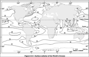
● The average salinity of the Atlantic Ocean is around 36 o/oo.
⮚ The highest salinity is recorded between 15° and 20° latitudes.
⮚ Maximum salinity (37 o/oo) is observed between 20° N and 30° N and 20° W – 60° W.
⮚ It gradually decreases towards the north. (As shown in figure below)
Statement-II is the correct explanation for Statement-I
● The North Sea, in spite of its location in higher latitudes, records higher salinity due to more saline water brought by the North Atlantic Drift.
● Baltic Sea records low salinity due to influx of river waters in large quantity.
● The Mediterranean Sea records higher salinity due to high evaporation.
● Salinity is, however, very low in Black Sea due to enormous fresh water influx by rivers.
 Incorrect
Answer: A
Explanation:
Both Statement-I and Statement-II are correct and Statement-II is the correct explanation for Statement-I
Salinity of ocean waters:
Salinity: It is the term used to define the total content of dissolved salts in sea water.
● It is calculated as the amount of salt (in gm) dissolved in 1,000 gm (1 kg) of seawater.
● It is usually expressed as parts per thousand (o/oo) or ppt.
Factors affecting ocean salinity are mentioned below:
● The salinity of water in the surface layer of oceans depends mainly on evaporation and precipitation.
● Surface salinity is greatly influenced in coastal regions by the fresh water flow from rivers, and in polar regions by the processes of freezing and thawing of ice.
● Wind, also influences salinity of an area by transferring water to other areas.
● The ocean currents contribute to the salinity variations.
● Salinity, temperature and density of water are interrelated. Hence, any change in the temperature or density influences the salinity of water in an area.
Statement-I is correct:
Horizontal distribution of salinity:
The Salinity in and around Atlantic Ocean:
● The average salinity of the Atlantic Ocean is around 36 o/oo.
⮚ The highest salinity is recorded between 15° and 20° latitudes.
⮚ Maximum salinity (37 o/oo) is observed between 20° N and 30° N and 20° W – 60° W.
⮚ It gradually decreases towards the north. (As shown in figure below)

Statement-II is the correct explanation for Statement-I
● The North Sea, in spite of its location in higher latitudes, records higher salinity due to more saline water brought by the North Atlantic Drift.
● Baltic Sea records low salinity due to influx of river waters in large quantity.
● The Mediterranean Sea records higher salinity due to high evaporation.
● Salinity is, however, very low in Black Sea due to enormous fresh water influx by rivers.


-
Question 2 of 5
2. Question
2. Consider the following statements:
1. Warm currents flow parallel to the east coasts of the continents in tropical and subtropical latitudes.
2. West coasts of the continents in the middle and higher latitudes are bordered by cold currents.
Which of the statements given above is/are correct?Correct
Answer: A
Explanation:
Only Statement 1 is correct
Statement 1 is correct:
Based on temperature, ocean currents can be classified as warm currents and cold currents:
Warm currents:
● The warm currents bring warm water into cold water areas and are usually observed on the east coast of continents in the low and middle latitudes (true in both hemispheres).
Reasons for formation of warm ocean currents on the eastern coasts of continents in tropical and sub-tropical regions:
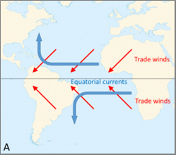
● Frictional drag of trade winds: In the tropical regions, planetary winds called trade winds blow from east to west just above the equator. The winds pull surface water with them, creating currents and carrying them from west to east, resulting into accumulation of warm waters in the eastern coast of the continents in these latitudes.


● Coriolis effect: The Coriolis effect, caused by the earth’s rotation, deflects ocean currents to the right in the northern hemisphere and to the left in the southern hemisphere. This deflection tends to push ocean currents towards the eastern coasts of continents.
● Shapes of the continents: The shapes and orientations of continents also influence the direction of ocean currents.
⮚ For example: The eastward-flowing currents along the eastern coasts of continents are often enhanced by the narrowing of ocean basins or the presence of coastal mountain ranges that act as barriers, forcing the warm water to flow parallel to the coastline – like in Gulf of Florida.


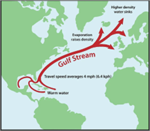
● Temperature gradients: Temperature differences between ocean regions also contribute to the formation of warm ocean currents. Warm water tends to flow from the equator towards the poles, and as this water moves pole ward, it can be deflected towards the eastern coasts of continents, further warming these regions.
Overall, the combination of these factors leads to the formation and maintenance of warm ocean currents along the eastern coasts of continents, influencing the climate and ecosystems of these regions.
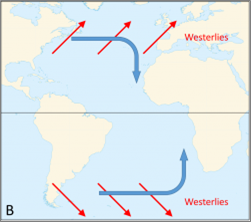
Statement 2 is incorrect: For the reasons explained above, warm ocean currents are found on the west coasts of continents in high latitudes, while cold currents are usually found on the west coast of the continents in the low and middle latitudes (true in both hemispheres) and on the east coast in the higher latitudes in the northern hemisphere.


 Incorrect
Answer: A
Explanation:
Only Statement 1 is correct
Statement 1 is correct:
Based on temperature, ocean currents can be classified as warm currents and cold currents:
Warm currents:
● The warm currents bring warm water into cold water areas and are usually observed on the east coast of continents in the low and middle latitudes (true in both hemispheres).
Reasons for formation of warm ocean currents on the eastern coasts of continents in tropical and sub-tropical regions:
● Frictional drag of trade winds: In the tropical regions, planetary winds called trade winds blow from east to west just above the equator. The winds pull surface water with them, creating currents and carrying them from west to east, resulting into accumulation of warm waters in the eastern coast of the continents in these latitudes.


● Coriolis effect: The Coriolis effect, caused by the earth’s rotation, deflects ocean currents to the right in the northern hemisphere and to the left in the southern hemisphere. This deflection tends to push ocean currents towards the eastern coasts of continents.
● Shapes of the continents: The shapes and orientations of continents also influence the direction of ocean currents.
⮚ For example: The eastward-flowing currents along the eastern coasts of continents are often enhanced by the narrowing of ocean basins or the presence of coastal mountain ranges that act as barriers, forcing the warm water to flow parallel to the coastline – like in Gulf of Florida.


● Temperature gradients: Temperature differences between ocean regions also contribute to the formation of warm ocean currents. Warm water tends to flow from the equator towards the poles, and as this water moves pole ward, it can be deflected towards the eastern coasts of continents, further warming these regions.
Overall, the combination of these factors leads to the formation and maintenance of warm ocean currents along the eastern coasts of continents, influencing the climate and ecosystems of these regions.
Statement 2 is incorrect: For the reasons explained above, warm ocean currents are found on the west coasts of continents in high latitudes, while cold currents are usually found on the west coast of the continents in the low and middle latitudes (true in both hemispheres) and on the east coast in the higher latitudes in the northern hemisphere.


-
Question 3 of 5
3. Question
3. These industries can be located in a wide variety of places. They are not dependent on any specific raw material, weight losing or otherwise. They largely depend on component parts which can be obtained anywhere. These are generally non-polluting industries. The important factor in deciding their location is accessibility by road network.
Which of the following types of industries is described in the above paragraph?Correct
Answer: D
Explanation:
The above paragraph describes the characteristics of Footloose Industries:
Footloose industries:
● Footloose industries can be located in a wide variety of places.
● They are not dependent on any specific raw material, weight losing or otherwise.
● They largely depend on component parts which can be obtained anywhere.
● They produce in small quantities and also employ a small labour force.
● These are generally not polluting industries.
● The important factor in their location is accessibility by road network.
Importance in India:
● Footloose industries are crucial for India’s economic development as they provide flexibility in terms of location, helping in balanced regional development.
● They also attract foreign investment, create jobs, and contribute significantly to export earnings.
● Their ability to establish operations in various locations helps mitigate regional disparities and promotes urbanization and industrialization across different parts of the country.Incorrect
Answer: D
Explanation:
The above paragraph describes the characteristics of Footloose Industries:
Footloose industries:
● Footloose industries can be located in a wide variety of places.
● They are not dependent on any specific raw material, weight losing or otherwise.
● They largely depend on component parts which can be obtained anywhere.
● They produce in small quantities and also employ a small labour force.
● These are generally not polluting industries.
● The important factor in their location is accessibility by road network.
Importance in India:
● Footloose industries are crucial for India’s economic development as they provide flexibility in terms of location, helping in balanced regional development.
● They also attract foreign investment, create jobs, and contribute significantly to export earnings.
● Their ability to establish operations in various locations helps mitigate regional disparities and promotes urbanization and industrialization across different parts of the country. -
Question 4 of 5
4. Question
4. Consider the following statements:
1. In extensive commercial grain cultivation, the yield per unit area is high but per unit labour productivity is low.
2. In intensive subsistence agriculture, there is low yield per acre but high yield per person.
Which of the statements given above is/are correct?Correct
Answer: D
Explanation:
Both the statements are incorrect
Statement 1 is incorrect:
About Extensive Commercial Grain Cultivation:
● Commercial grain cultivation is practised in the interior parts of semi-arid lands of the mid-latitudes.
⮚ This type of agriculture is best developed in Eurasian steppes, the Canadian and American Prairies, the Pampas of Argentina, the Velds of South Africa, the Australian Downs and the Canterbury Plains of New Zealand.


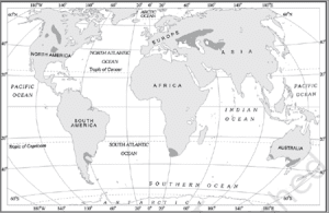
● Wheat is the principal crop, though other crops like corn, barley, oats and rye are also grown.
● The size of the farm is very large, therefore entire operations of cultivation from ploughing to harvesting are mechanised.
● There is low yield per unit area but high yield per person (per labour productivity is high).
⮚ Reason: In the areas practising commercial grain cultivation, the areas of production are high, as the farming is intensive, but due to the low population and high degree of mechanization, the number of people employed in these farms is less. Due to the high level of scientific and technological skills employed in the production activities, the total yield is high, which results in a very high per person yield, but due to the extensive nature of farming and low pressure per unit area of land, yield per acre is low.
Statement 2 is incorrect:
About Intensive Subsistence Agriculture:
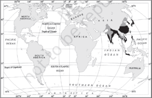
● This type of agriculture is largely found in densely populated regions of monsoon Asia.
Basically, there are two types of intensive subsistence agriculture-
1. Intensive subsistence agriculture dominated by wet paddy cultivation-
⮚ This type of agriculture is characterised by dominance of the rice crop.
● Land holdings are very small due to the high density of population.
● Farmers work with the help of family labour leading to intensive use of land.
● Use of machinery is limited and most of the agricultural operations are done by manual labour.
● Farm yard manure is used to maintain the fertility of the soil.
● Therefore, in this type of agriculture, the yield per unit area is high but per labour productivity is low.
2. Intensive subsistence agriculture dominated by crops other than paddy:
⮚ Due to the difference in relief, climate, soil and some of the other geographical factors, it is not practical to grow paddy in many parts of monsoon Asia.
⮚ Wheat, soyabean, barley and sorghum are grown in northern China, Manchuria, North Korea and North Japan.
⮚ In India wheat is grown in western parts of the Indo-Gangetic plains and millets are grown in dry parts of western and southern India.
⮚ Most of the characteristics of this type of agriculture are similar to those dominated by wet paddy except that irrigation is often used.


 Incorrect
Answer: D
Explanation:
Both the statements are incorrect
Statement 1 is incorrect:
About Extensive Commercial Grain Cultivation:
● Commercial grain cultivation is practised in the interior parts of semi-arid lands of the mid-latitudes.
⮚ This type of agriculture is best developed in Eurasian steppes, the Canadian and American Prairies, the Pampas of Argentina, the Velds of South Africa, the Australian Downs and the Canterbury Plains of New Zealand.


● Wheat is the principal crop, though other crops like corn, barley, oats and rye are also grown.
● The size of the farm is very large, therefore entire operations of cultivation from ploughing to harvesting are mechanised.
● There is low yield per unit area but high yield per person (per labour productivity is high).
⮚ Reason: In the areas practising commercial grain cultivation, the areas of production are high, as the farming is intensive, but due to the low population and high degree of mechanization, the number of people employed in these farms is less. Due to the high level of scientific and technological skills employed in the production activities, the total yield is high, which results in a very high per person yield, but due to the extensive nature of farming and low pressure per unit area of land, yield per acre is low.
Statement 2 is incorrect:
About Intensive Subsistence Agriculture:
● This type of agriculture is largely found in densely populated regions of monsoon Asia.
Basically, there are two types of intensive subsistence agriculture-
1. Intensive subsistence agriculture dominated by wet paddy cultivation-
⮚ This type of agriculture is characterised by dominance of the rice crop.
● Land holdings are very small due to the high density of population.
● Farmers work with the help of family labour leading to intensive use of land.
● Use of machinery is limited and most of the agricultural operations are done by manual labour.
● Farm yard manure is used to maintain the fertility of the soil.
● Therefore, in this type of agriculture, the yield per unit area is high but per labour productivity is low.
2. Intensive subsistence agriculture dominated by crops other than paddy:
⮚ Due to the difference in relief, climate, soil and some of the other geographical factors, it is not practical to grow paddy in many parts of monsoon Asia.
⮚ Wheat, soyabean, barley and sorghum are grown in northern China, Manchuria, North Korea and North Japan.
⮚ In India wheat is grown in western parts of the Indo-Gangetic plains and millets are grown in dry parts of western and southern India.
⮚ Most of the characteristics of this type of agriculture are similar to those dominated by wet paddy except that irrigation is often used.


-
Question 5 of 5
5. Question
5. With reference to the ‘Sustainable Finance for Tiger Landscapes Conference 2024’, consider the following statements:
1. The Wildlife Trust of India (WTI) and the Tiger Conservation Coalition have recently hosted this Conference.
2. The mission of this conference is to mobilize funding worth $100 billion over 10 years for the preservation of tiger landscapes.
Which of the statements given above is/are correct?Correct
Answer: D
Explanation:
Statements 1 and 2 are incorrect: The Bhutanese government and the Tiger Conservation Coalition co-hosted the Sustainable Finance for Tiger Landscapes Conference on Earth Day 2024 (22 April, 2024) in Paro, Bhutan to mobilise the funding for tiger conservation.
A whopping $1 billion are needed over the next decade to conserve tigers and their habitats across Asia. The aim of the conference was to mobilise $1 billion in new funding over 10 years for the preservation of tiger landscapes, which are vital to maintaining biodiversity, sequestering carbon, supplying resources to over 100 million people, and ensuring the overall health of the planet.
Additional information
● Tiger Range Countries present included Bangladesh, Bhutan, Cambodia, China, India, Kazakhstan, Malaysia, Nepal, Thailand, and Vietnam.
● The Tiger Conservation Coalition was formed ahead of the 2022 Year of the Tiger.
The Tiger Conservation Coalition brings together leading biologists and experts in wildlife crime, human-wildlife coexistence, policy, finance, development and communications, with unprecedented alignment on achieving tiger conservation at scale. Its member organisations include various non-governmental organisations such as the International Union for Conservation of Nature (IUCN), the Environmental Investigation Agency; Fauna & Flora; Natural State; Panthera; TRAFFIC; the United Nations Development Programme (UNDP); the Wildlife Conservation Society; Worldwide Fund for Nature (WWF) and the Zoological Society of London (ZSL).Incorrect
Answer: D
Explanation:
Statements 1 and 2 are incorrect: The Bhutanese government and the Tiger Conservation Coalition co-hosted the Sustainable Finance for Tiger Landscapes Conference on Earth Day 2024 (22 April, 2024) in Paro, Bhutan to mobilise the funding for tiger conservation.
A whopping $1 billion are needed over the next decade to conserve tigers and their habitats across Asia. The aim of the conference was to mobilise $1 billion in new funding over 10 years for the preservation of tiger landscapes, which are vital to maintaining biodiversity, sequestering carbon, supplying resources to over 100 million people, and ensuring the overall health of the planet.
Additional information
● Tiger Range Countries present included Bangladesh, Bhutan, Cambodia, China, India, Kazakhstan, Malaysia, Nepal, Thailand, and Vietnam.
● The Tiger Conservation Coalition was formed ahead of the 2022 Year of the Tiger.
The Tiger Conservation Coalition brings together leading biologists and experts in wildlife crime, human-wildlife coexistence, policy, finance, development and communications, with unprecedented alignment on achieving tiger conservation at scale. Its member organisations include various non-governmental organisations such as the International Union for Conservation of Nature (IUCN), the Environmental Investigation Agency; Fauna & Flora; Natural State; Panthera; TRAFFIC; the United Nations Development Programme (UNDP); the Wildlife Conservation Society; Worldwide Fund for Nature (WWF) and the Zoological Society of London (ZSL).


