Day-665
Quiz-summary
0 of 5 questions completed
Questions:
- 1
- 2
- 3
- 4
- 5
Information
DAILY MCQ
You have already completed the quiz before. Hence you can not start it again.
Quiz is loading...
You must sign in or sign up to start the quiz.
You have to finish following quiz, to start this quiz:
Results
0 of 5 questions answered correctly
Your time:
Time has elapsed
You have reached 0 of 0 points, (0)
Categories
- Not categorized 0%
- 1
- 2
- 3
- 4
- 5
- Answered
- Review
-
Question 1 of 5
1. Question
1. Consider the following pairs:
Crater lakes in India – States
1. Dhala crater – Rajasthan
2. Ramgarh crater – Madhya Pradesh
3. Lonar crater – Maharashtra
How many of the above pairs are correctly matched?Correct
Answer: A
Explanation: Only one pair is matched correctly
● In the 4.5 billion years of its existence, countless extraterrestrial, cosmic bodies have entered into Earth’s atmosphere.
● Some of them burn up without even touching the surface, while some have left lasting scars on our planet, with one historical impact wiping out an entire species.
● Today, three of these ancient star wounds, known as meteor impact craters, are found in India, which are – Ramgarh in Rajasthan, Lonar in Maharashtra and Dhala in Madhya Pradesh.
Pair 1 is matched incorrectly:
Dhala crater:
● Dhala crater is an impact structure formed by an asteroid impact.
● It is situated in Shivpuri district of Madhya Pradesh state in India.
● It is the largest impact structure in India and between the Mediterranean and Southeast Asia.

Pair 2 is matched incorrectly:
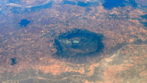
The Ramgarh Crater:
● Ramgarh crater is a meteor impact crater of 3.5 kilometres diameter in Kota plateau of Vindhya range located in Baran district in Rajasthan state of India.
● It is believed to have been formed 600 million years ago.
● It is the country’s third and the state’s first crater.
● Recently, the Rajasthan government officially recognised the Ramgarh Crater as the country’s first Geo-Heritage Site.
● It has become the 200th crater of the World Geo-Heritage.
Pair 3 is matched correctly:
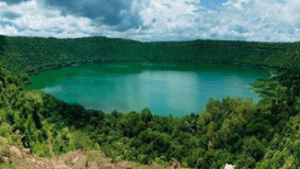
The Lonar Crater:
● Lonar lake is a lake of lagoon in Buldhana district of Maharashtra state.
● It was created due to a meteorite.
● It is the only major hover-back in basalt rock.
● Its water is alkaline.
● Lonar Lake has been declared as Wildlife Sanctuary and Ramsar site for the conservation and conservation of Lonar lake.
● The formation of the lake is believed to have been 52,000 ± 6,000 years ago.


 Incorrect
Answer: A
Explanation: Only one pair is matched correctly
● In the 4.5 billion years of its existence, countless extraterrestrial, cosmic bodies have entered into Earth’s atmosphere.
● Some of them burn up without even touching the surface, while some have left lasting scars on our planet, with one historical impact wiping out an entire species.
● Today, three of these ancient star wounds, known as meteor impact craters, are found in India, which are – Ramgarh in Rajasthan, Lonar in Maharashtra and Dhala in Madhya Pradesh.
Pair 1 is matched incorrectly:
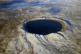
Dhala crater:
● Dhala crater is an impact structure formed by an asteroid impact.
● It is situated in Shivpuri district of Madhya Pradesh state in India.
● It is the largest impact structure in India and between the Mediterranean and Southeast Asia.


Pair 2 is matched incorrectly:
The Ramgarh Crater:
● Ramgarh crater is a meteor impact crater of 3.5 kilometres diameter in Kota plateau of Vindhya range located in Baran district in Rajasthan state of India.
● It is believed to have been formed 600 million years ago.
● It is the country’s third and the state’s first crater.
● Recently, the Rajasthan government officially recognised the Ramgarh Crater as the country’s first Geo-Heritage Site.
● It has become the 200th crater of the World Geo-Heritage.

Pair 3 is matched correctly:
The Lonar Crater:
● Lonar lake is a lake of lagoon in Buldhana district of Maharashtra state.
● It was created due to a meteorite.
● It is the only major hover-back in basalt rock.
● Its water is alkaline.
● Lonar Lake has been declared as Wildlife Sanctuary and Ramsar site for the conservation and conservation of Lonar lake.
● The formation of the lake is believed to have been 52,000 ± 6,000 years ago.


-
Question 2 of 5
2. Question
2. Consider the following statements:
1. All earthquakes occur in the earth’s crust.
2. All earthquakes occurring on the ocean floor result in tsunami.
3. All earthquakes occur along the tectonic plate margins.
How many of the statements given above are incorrect?Correct
Answer: C
Explanation: All statements are incorrect
Statement 1 is incorrect:
● While the majority of earthquakes do indeed happen within the Earth’s crust, they can also occur in other layers of the Earth, such as the mantle and the outer core.
● Earthquakes based on the depth of focus can be categorized as:
⮚ The earthquakes are divided into three zones: shallow, intermediate, and deep based on their depth which range between 0 – 700 km.
o Shallow earthquakes have a focus 0 – 70 km deep.
o Intermediate earthquakes have a focus 70 – 300 km deep.
o Deep earthquakes have a focus 300 – 700 km deep.
⮚ Example – Wadati–Benioff zone: It is a zone of subduction along which earthquakes are common. The most powerful earthquakes occur along this zone (most powerful earthquakes occur along the convergent boundary).
o Differential motion along the zone produces numerous earthquakes, the foci of which may be as deep as about 700 kilometres.
Statement 2 is incorrect:
● Generation of Tsunami: Tsunamis are typically generated by undersea earthquakes of significant magnitude that involve vertical movement of the seafloor. When the seafloor shifts vertically, it displaces a large volume of water, which then propagates outward as a series of powerful ocean waves.
⮚ However, not all undersea earthquakes produce significant vertical displacement or generate the necessary energy to create a tsunami.
⮚ Factors such as the depth, magnitude, and type of fault movement play crucial roles in determining whether a tsunami will be generated.
⮚ Additionally, earthquakes that occur away from the oceanic trenches or with predominantly horizontal movement may not produce tsunamis.
● Tsunamis can also be generated by other undersea events, such as volcanic eruptions, submarine landslides, or the collapse of underwater volcanic islands, which can displace water and generate large waves.
● However, the majority of tsunamis are indeed triggered by undersea earthquakes.
Statement 3 is incorrect:
● The earth’s tectonic plates are constantly in motion, and most earthquakes occur at plate boundaries where the plates interact.
● These interactions can take several forms:
⮚ Convergent boundaries: At convergent boundaries, plates collide with each other, leading to earthquakes caused by the compression and subduction of one plate beneath the other.
⮚ Divergent boundaries: At divergent boundaries, plates move away from each other, creating earthquakes due to the tension and stretching of the crust as new crust forms.
⮚ Transform boundaries: At transform boundaries, plates slide past each other horizontally, causing earthquakes due to the friction and grinding between the plates.
● However, earthquakes can also occur within tectonic plates, away from plate boundaries.
● These intraplate earthquakes can happen due to various factors, including ancient faults within the plates, volcanic activity, or even human-induced causes such as reservoir-induced seismicity from the filling of large reservoirs behind dams.
⮚ Example – Earthquake induced by the Koyna Dam in Maharashtra in 1967.
● While less common than earthquakes at plate boundaries, intraplate earthquakes can still be significant and have the potential to cause damage and affect populated areas.Incorrect
Answer: C
Explanation: All statements are incorrect
Statement 1 is incorrect:
● While the majority of earthquakes do indeed happen within the Earth’s crust, they can also occur in other layers of the Earth, such as the mantle and the outer core.
● Earthquakes based on the depth of focus can be categorized as:
⮚ The earthquakes are divided into three zones: shallow, intermediate, and deep based on their depth which range between 0 – 700 km.
o Shallow earthquakes have a focus 0 – 70 km deep.
o Intermediate earthquakes have a focus 70 – 300 km deep.
o Deep earthquakes have a focus 300 – 700 km deep.
⮚ Example – Wadati–Benioff zone: It is a zone of subduction along which earthquakes are common. The most powerful earthquakes occur along this zone (most powerful earthquakes occur along the convergent boundary).
o Differential motion along the zone produces numerous earthquakes, the foci of which may be as deep as about 700 kilometres.
Statement 2 is incorrect:
● Generation of Tsunami: Tsunamis are typically generated by undersea earthquakes of significant magnitude that involve vertical movement of the seafloor. When the seafloor shifts vertically, it displaces a large volume of water, which then propagates outward as a series of powerful ocean waves.
⮚ However, not all undersea earthquakes produce significant vertical displacement or generate the necessary energy to create a tsunami.
⮚ Factors such as the depth, magnitude, and type of fault movement play crucial roles in determining whether a tsunami will be generated.
⮚ Additionally, earthquakes that occur away from the oceanic trenches or with predominantly horizontal movement may not produce tsunamis.
● Tsunamis can also be generated by other undersea events, such as volcanic eruptions, submarine landslides, or the collapse of underwater volcanic islands, which can displace water and generate large waves.
● However, the majority of tsunamis are indeed triggered by undersea earthquakes.
Statement 3 is incorrect:
● The earth’s tectonic plates are constantly in motion, and most earthquakes occur at plate boundaries where the plates interact.
● These interactions can take several forms:
⮚ Convergent boundaries: At convergent boundaries, plates collide with each other, leading to earthquakes caused by the compression and subduction of one plate beneath the other.
⮚ Divergent boundaries: At divergent boundaries, plates move away from each other, creating earthquakes due to the tension and stretching of the crust as new crust forms.
⮚ Transform boundaries: At transform boundaries, plates slide past each other horizontally, causing earthquakes due to the friction and grinding between the plates.
● However, earthquakes can also occur within tectonic plates, away from plate boundaries.
● These intraplate earthquakes can happen due to various factors, including ancient faults within the plates, volcanic activity, or even human-induced causes such as reservoir-induced seismicity from the filling of large reservoirs behind dams.
⮚ Example – Earthquake induced by the Koyna Dam in Maharashtra in 1967.
● While less common than earthquakes at plate boundaries, intraplate earthquakes can still be significant and have the potential to cause damage and affect populated areas. -
Question 3 of 5
3. Question
3. Consider the following:
1. Long winter nights
2. Cloudless and clear sky
3. Presence of moist air near the ground surface
4. Slow movement of air
5. Snow-covered ground surface
How many of the above are the ideal conditions for temperature inversion?Correct
Answer: C
Explanation: The presence of moist air near the ground surface is not an ideal condition for temperature inversion.
Inversion of Temperature-
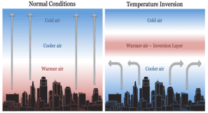
● Normal lapse rate: Normally, temperature decreases with an increase in elevation at a rate of 1 degree for every 165 meters in the troposphere. It is called the normal lapse rate.
● Temperature inversion: At times, the situation is reversed, and the normal lapse rate is inverted. It is called the Inversion of temperature.


Conditions required for temperature inversion:
● A long winter night with clear skies and still air is an ideal situation for inversion. The heat of the day is radiated off during the night, and by early morning hours, the earth is cooler than the air above.
⮚ Dense fogs in the mornings are common occurrences especially during the winter season. This inversion commonly lasts for a few hours until the sun comes up and begins to warm the earth.
● Over polar areas, temperature inversion is normal throughout the year as the ground surface is covered with snow which helps in reflecting the incoming solar waves.
● Dry air near the ground surface: It limits the absorption of the radiated heat from the Earth’s surface.
● Surface inversion promotes stability in the lower layers of the atmosphere.
● Due to air drainage: The inversion takes place in hills and mountains due to air drainage.
⮚ Cold air at the hills and mountains, produced during night, flows under the influence of gravity.
⮚ Being heavy and dense, the cold air acts almost like water and moves down the slope to pile up deeply in pockets and valley bottoms with warm air above.
⮚ This is called air drainage. It protects plants from frost damage.Incorrect
Answer: C
Explanation: The presence of moist air near the ground surface is not an ideal condition for temperature inversion.
Inversion of Temperature-
● Normal lapse rate: Normally, temperature decreases with an increase in elevation at a rate of 1 degree for every 165 meters in the troposphere. It is called the normal lapse rate.
● Temperature inversion: At times, the situation is reversed, and the normal lapse rate is inverted. It is called the Inversion of temperature.


Conditions required for temperature inversion:
● A long winter night with clear skies and still air is an ideal situation for inversion. The heat of the day is radiated off during the night, and by early morning hours, the earth is cooler than the air above.
⮚ Dense fogs in the mornings are common occurrences especially during the winter season. This inversion commonly lasts for a few hours until the sun comes up and begins to warm the earth.
● Over polar areas, temperature inversion is normal throughout the year as the ground surface is covered with snow which helps in reflecting the incoming solar waves.
● Dry air near the ground surface: It limits the absorption of the radiated heat from the Earth’s surface.
● Surface inversion promotes stability in the lower layers of the atmosphere.
● Due to air drainage: The inversion takes place in hills and mountains due to air drainage.
⮚ Cold air at the hills and mountains, produced during night, flows under the influence of gravity.
⮚ Being heavy and dense, the cold air acts almost like water and moves down the slope to pile up deeply in pockets and valley bottoms with warm air above.
⮚ This is called air drainage. It protects plants from frost damage. -
Question 4 of 5
4. Question
4. Consider the following statements about the naming system of tropical cyclones in the Indian Ocean region:
1. The names of tropical cyclones will not be repeated.
2. The maximum length of the name will be eight letters.
3. A tropical cyclone from south China Sea which crosses Thailand and emerges into the Bay of Bengal as a Tropical cyclone will be given a new name.
How many of the statements given above are correct?Correct
Answer: B
Explanation: Statement 3 is incorrect
Naming of tropical cyclones over north Indian Ocean-
The history:
● The World Meteorological Organization (WMO) Panel on Tropical Cyclones at its twenty-seventh Session held in 2000 in Muscat, Oman, agreed in principle to assign names to the tropical cyclones in the Bay of Bengal and Arabian Sea.
● After long deliberations among the member countries, the naming of the tropical cyclones over the north Indian Ocean commenced from September 2004.
● The Regional Specialised Meteorological Centre (RSMC) tropical cyclones, New Delhi gives a tropical cyclone an identification name from the given name list.
● The identification system covers both the Arabian Sea and the Bay of Bengal.
Criteria for implementation of the list of names:
RSMC New Delhi will be responsible for naming tropical cyclones that have formed over the Bay of Bengal and the Arabian Sea when they have been analyzed with maximum wind speeds of 34 knots or more.
● The proposed name should be neutral to (a) politics and political figures (b) religious believes, (c) cultures and (d) gender
● Name should be chosen in such a way that it does not hurt the sentiments of any group of population over the globe
● It should not be very rude and cruel in nature
● It should be short, easy to pronounce, and should not be offensive to any member
● The maximum length of the name will be eight letters
● The proposed name should be provided along with its pronunciation, meaning and voice over
● The Panel reserves the right to reject any name, if any of the criteria above is not satisfied.
● The name of a tropical cyclone from south China Sea which crosses Thailand and emerges into the Bay of Bengal as a Tropical cyclone will not be changed.
● The names of tropical cyclones will not be repeated
● The names of tropical cyclones over the north Indian Ocean will not be repeated, once used it will cease to be used again. The name should be new.
● It should not be there in the already existing list of any of the RSMCs worldwide, including RSMC New Delhi.Incorrect
Answer: B
Explanation: Statement 3 is incorrect
Naming of tropical cyclones over north Indian Ocean-
The history:
● The World Meteorological Organization (WMO) Panel on Tropical Cyclones at its twenty-seventh Session held in 2000 in Muscat, Oman, agreed in principle to assign names to the tropical cyclones in the Bay of Bengal and Arabian Sea.
● After long deliberations among the member countries, the naming of the tropical cyclones over the north Indian Ocean commenced from September 2004.
● The Regional Specialised Meteorological Centre (RSMC) tropical cyclones, New Delhi gives a tropical cyclone an identification name from the given name list.
● The identification system covers both the Arabian Sea and the Bay of Bengal.
Criteria for implementation of the list of names:
RSMC New Delhi will be responsible for naming tropical cyclones that have formed over the Bay of Bengal and the Arabian Sea when they have been analyzed with maximum wind speeds of 34 knots or more.
● The proposed name should be neutral to (a) politics and political figures (b) religious believes, (c) cultures and (d) gender
● Name should be chosen in such a way that it does not hurt the sentiments of any group of population over the globe
● It should not be very rude and cruel in nature
● It should be short, easy to pronounce, and should not be offensive to any member
● The maximum length of the name will be eight letters
● The proposed name should be provided along with its pronunciation, meaning and voice over
● The Panel reserves the right to reject any name, if any of the criteria above is not satisfied.
● The name of a tropical cyclone from south China Sea which crosses Thailand and emerges into the Bay of Bengal as a Tropical cyclone will not be changed.
● The names of tropical cyclones will not be repeated
● The names of tropical cyclones over the north Indian Ocean will not be repeated, once used it will cease to be used again. The name should be new.
● It should not be there in the already existing list of any of the RSMCs worldwide, including RSMC New Delhi. -
Question 5 of 5
5. Question
5. Consider the following statements:
1. Brahmaputra river flows to the north of Kaziranga National Park.
2. Kabini river flows to the south of Bandipur National Park.
3. Banas river flows to the north of Ranthambore National Park.
How many of the statements given above are correct?Correct
Answer: B
Explanation:
Statement 1 is correct:
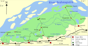
Rivers and landscapes of Kaziranga
● Kaziranga National Park is located in the north-eastern state of Assam, India.
● It is a UNESCO World Heritage Site and is known for its unique landscape and diverse river systems.
Rivers of Kaziranga:
● Several rivers and water bodies are found in and around Kaziranga National Park.
● The most prominent river is the Brahmaputra, which flows along the northern boundary of the park.
● The Brahmaputra is one of the major rivers of Asia and plays a crucial role in shaping the landscape of the region.
● It brings rich alluvial soil from the Himalayas, which contributes to the fertility of the floodplains and supports the growth of diverse vegetation.
● Apart from the Brahmaputra, Kaziranga is also crisscrossed by numerous smaller rivers and streams, such as the Diphlu River, Mora Diphlu River, and Mora Dhansiri River.


Statement 2 is incorrect:
● Bandipur National Park is located in Gundulpet taluk, Chamarajanagar district, Karnataka.
● It was established as a tiger reserve under Project Tiger in 1973. The Bandipur National Park has the second highest Tiger population in India.
● The Park is part of Nilgiri Biosphere Reserve making it the largest protected area in Southern India and the largest habitat of Wild Elephants in South Asia.
Geography of Bandipur National Park:
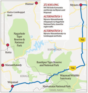
● The park is flanked by the Kabini River in the north and the Moyar in the south. The Nugu river runs through the park.
● Bandipur has a typical tropical climate with distinct wet and dry seasons. The dry and hot period usually begins in early March and can last till the arrival of the monsoon rains in June.
● Bandipur National Park shares its boundary with 3 other National parks namely Nagarahole National Park, Wayanad National Park and Mudumalai National Park.


Statement 3 is correct:
Ranthambore National Park:
● It is a national park in Rajasthan, India, with an area of 1,334 sq. km.
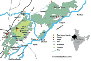
● It is bounded to the north by the Banas River and to the south by the Chambal River.
● It is named after the historic Ranthambore Fort, which lies within the park.
● It harbours dry deciduous forests and open grassy meadows.


Source: 1. https://nagaon.assam.gov.in/tourist-place-detail/220#:~:text=Kaziranga%20National%20Park%20lies%20partly,Anglong%20hills%20on%20the%20South.
2. https://www.bandipurnationalpark.in/about-bandipur-national-park.htmlIncorrect
Answer: B
Explanation:
Statement 1 is correct:
Rivers and landscapes of Kaziranga
● Kaziranga National Park is located in the north-eastern state of Assam, India.
● It is a UNESCO World Heritage Site and is known for its unique landscape and diverse river systems.
Rivers of Kaziranga:
● Several rivers and water bodies are found in and around Kaziranga National Park.
● The most prominent river is the Brahmaputra, which flows along the northern boundary of the park.
● The Brahmaputra is one of the major rivers of Asia and plays a crucial role in shaping the landscape of the region.
● It brings rich alluvial soil from the Himalayas, which contributes to the fertility of the floodplains and supports the growth of diverse vegetation.
● Apart from the Brahmaputra, Kaziranga is also crisscrossed by numerous smaller rivers and streams, such as the Diphlu River, Mora Diphlu River, and Mora Dhansiri River.


Statement 2 is incorrect:
● Bandipur National Park is located in Gundulpet taluk, Chamarajanagar district, Karnataka.
● It was established as a tiger reserve under Project Tiger in 1973. The Bandipur National Park has the second highest Tiger population in India.
● The Park is part of Nilgiri Biosphere Reserve making it the largest protected area in Southern India and the largest habitat of Wild Elephants in South Asia.
Geography of Bandipur National Park:
● The park is flanked by the Kabini River in the north and the Moyar in the south. The Nugu river runs through the park.
● Bandipur has a typical tropical climate with distinct wet and dry seasons. The dry and hot period usually begins in early March and can last till the arrival of the monsoon rains in June.
● Bandipur National Park shares its boundary with 3 other National parks namely Nagarahole National Park, Wayanad National Park and Mudumalai National Park.


Statement 3 is correct:
Ranthambore National Park:
● It is a national park in Rajasthan, India, with an area of 1,334 sq. km.
● It is bounded to the north by the Banas River and to the south by the Chambal River.
● It is named after the historic Ranthambore Fort, which lies within the park.
● It harbours dry deciduous forests and open grassy meadows.


Source: 1. https://nagaon.assam.gov.in/tourist-place-detail/220#:~:text=Kaziranga%20National%20Park%20lies%20partly,Anglong%20hills%20on%20the%20South.
2. https://www.bandipurnationalpark.in/about-bandipur-national-park.html


