Day-591
Quiz-summary
0 of 5 questions completed
Questions:
- 1
- 2
- 3
- 4
- 5
Information
DAILY MCQ
You have already completed the quiz before. Hence you can not start it again.
Quiz is loading...
You must sign in or sign up to start the quiz.
You have to finish following quiz, to start this quiz:
Results
0 of 5 questions answered correctly
Your time:
Time has elapsed
You have reached 0 of 0 points, (0)
Categories
- Not categorized 0%
- 1
- 2
- 3
- 4
- 5
- Answered
- Review
-
Question 1 of 5
1. Question
1. Consider the following statements:
1. Natural rubber is a native plant of warm humid Amazon forests.
2. Natural rubber is naturally suited for the colder conditions in the Northeast India.
3. Assam is the largest producer of rubber in India.
How many of the above statements are correct?Correct
Answer: A
Explanation: Only statement 1 is correct
Statement 1 is correct:
• Natural rubber is a native of warm humid Amazon forests.
• The Hevea brasiliensis is the main source of natural rubber, native to the Amazon river basin, and was introduced to tropical Asia and Africa by the British Government in the late 19th century.
• Agro-climatic conditions: The rubber tree grows in a wide range of agro climates and soil conditions, if well-distributed rainfall of about 200 cm is received annually.
Statement 2 is incorrect:
• Natural rubber is not naturally suited for the colder conditions in the Northeast although it is one of the largest producers of rubber in India.
Statement 3 is incorrect:
• The first rubber plantations in India were set up in 1895 on the hill slopes of Kerala.
• Kerala is the largest producer of natural rubber in India.
• Major areas: Kottayam, Kollam, Ernakulam, Kozhikode districts produce practically all the rubber of this state.Incorrect
Answer: A
Explanation: Only statement 1 is correct
Statement 1 is correct:
• Natural rubber is a native of warm humid Amazon forests.
• The Hevea brasiliensis is the main source of natural rubber, native to the Amazon river basin, and was introduced to tropical Asia and Africa by the British Government in the late 19th century.
• Agro-climatic conditions: The rubber tree grows in a wide range of agro climates and soil conditions, if well-distributed rainfall of about 200 cm is received annually.
Statement 2 is incorrect:
• Natural rubber is not naturally suited for the colder conditions in the Northeast although it is one of the largest producers of rubber in India.
Statement 3 is incorrect:
• The first rubber plantations in India were set up in 1895 on the hill slopes of Kerala.
• Kerala is the largest producer of natural rubber in India.
• Major areas: Kottayam, Kollam, Ernakulam, Kozhikode districts produce practically all the rubber of this state. -
Question 2 of 5
2. Question
2. Consider the following statements:
1. The Prime Meridian and the Equator cross each other in the Gulf of Guinea.
2. Congo and Zambezi rivers empty into the Gulf of Guinea.
Which of the statements given above is/are correct?Correct
Answer: A
Explanation:
Statement 1 is correct:
• The Gulf of Guinea is the northeastern most part of the tropical Atlantic Ocean from Cape Lopez in Gabon, north and west to Cape Palmas in Liberia.
• Null Island, defined as the intersection of the Equator and Prime Meridian, is in this gulf.
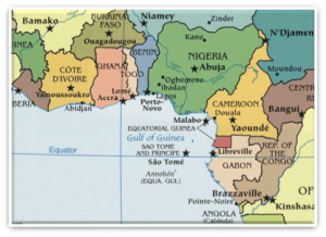
Statement 2 is incorrect:
• Niger River drains into Atlantic Ocean while Zambezi River drains into Indian Ocean.


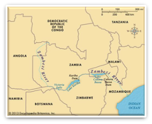 Incorrect
Answer: A
Explanation:
Statement 1 is correct:
• The Gulf of Guinea is the northeastern most part of the tropical Atlantic Ocean from Cape Lopez in Gabon, north and west to Cape Palmas in Liberia.
• Null Island, defined as the intersection of the Equator and Prime Meridian, is in this gulf.

Statement 2 is incorrect:
• Niger River drains into Atlantic Ocean while Zambezi River drains into Indian Ocean.


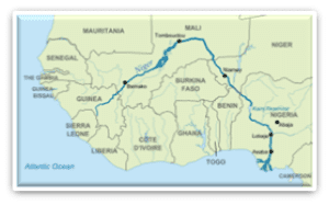


-
Question 3 of 5
3. Question
3. Consider the following pairs:
Places – Countries
1. Saada province – Yemen
2. Kachin province – Myanmar
3. Essquibo region – Spain
How many of the above pairs are correctly matched?Correct
Answer: B
Explanation:
Pair 1 is matched correctly:
• Saada is one of the governorates of Yemen.
• It is the epicentre of Zaydism and a place of origin of the Houthi group.


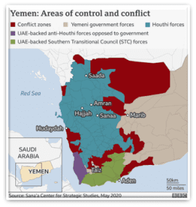
Pair 2 is matched correctly:
• The Kachin area, also known as Kachin State, is a region located in northern Myanmar (Burma).
• It is one of the 14 administrative divisions of Myanmar and shares borders with China and India.
• The area is primarily inhabited by the Kachin people, an ethnic group indigenous to the region.
• The Kachin area has been characterized by ethnic tensions and armed conflicts between the Kachin Independence Army (KIA) and the Myanmar government forces.
• The KIA, which represents the interests of the Kachin people, has been fighting for greater autonomy and self-determination.
Pair 3 is matched incorrectly:
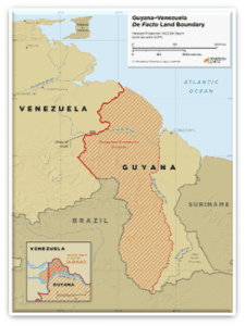
• The Essequibo region is more than two-thirds of the territory of Guyana and is home to 125,000 of its 800,000 citizens.
• Location: A geographical region in the northeast of South America.
• Significance: The region also has the world’s biggest crude oil reserves per capita.
• This region has been in news due to ongoing land conflict between Guyana and Venezuela.


 Incorrect
Answer: B
Explanation:
Pair 1 is matched correctly:
• Saada is one of the governorates of Yemen.
• It is the epicentre of Zaydism and a place of origin of the Houthi group.


Pair 2 is matched correctly:
• The Kachin area, also known as Kachin State, is a region located in northern Myanmar (Burma).
• It is one of the 14 administrative divisions of Myanmar and shares borders with China and India.
• The area is primarily inhabited by the Kachin people, an ethnic group indigenous to the region.
• The Kachin area has been characterized by ethnic tensions and armed conflicts between the Kachin Independence Army (KIA) and the Myanmar government forces.
• The KIA, which represents the interests of the Kachin people, has been fighting for greater autonomy and self-determination.
Pair 3 is matched incorrectly:
• The Essequibo region is more than two-thirds of the territory of Guyana and is home to 125,000 of its 800,000 citizens.
• Location: A geographical region in the northeast of South America.
• Significance: The region also has the world’s biggest crude oil reserves per capita.
• This region has been in news due to ongoing land conflict between Guyana and Venezuela.


-
Question 4 of 5
4. Question
4. Consider the following statements:
Statement-I: Agra and Darjeeling are located on the same latitude, but temperature in January in Agra is 16 degree Celsius whereas it is only 4 degree Celsius in Darjeeling.
Statement-II: Higher mountainous regions have a very thin layer of air.
Which one of the following is correct in respect of the above statements?Correct
Answer: A
Explanation: Both Statement-I and Statement-II are correct and Statement-II is the correct explanation for Statement-I
Statement-I is correct:
• Agra and Darjeeling are located on the same latitude, but temperature of January in Agra is 16 degree Celsius whereas it is only 4 degree Celsius in Darjeeling.
• The climate of a particular region is influenced by various factors, including latitude, altitude, distance from the sea, and geographical features such as mountains.
• In the case of Agra and Darjeeling, the primary cause of climatic difference is the difference in altitude.
Statement-II is correct and is the correct explanation for Statement-I:
• Under normal conditions, the temperature usually decreases with an increase in altitude in the troposphere at a rate of 6.5 degrees for every 1 km. This is called the normal lapse rate.
• As altitude increases, the amount of gas molecules in the air decreases—the air becomes less dense.
• Thin air exerts less pressure than air at a lower altitude.
• High-altitude locations are usually much colder than areas closer to sea level.
• This is due to the low air pressure. Air expands as it rises, and the fewer gas molecules including nitrogen, oxygen, and carbon dioxide—have fewer chances to bump into each other.
• That is why Darjeeling is colder compared to Agra.Incorrect
Answer: A
Explanation: Both Statement-I and Statement-II are correct and Statement-II is the correct explanation for Statement-I
Statement-I is correct:
• Agra and Darjeeling are located on the same latitude, but temperature of January in Agra is 16 degree Celsius whereas it is only 4 degree Celsius in Darjeeling.
• The climate of a particular region is influenced by various factors, including latitude, altitude, distance from the sea, and geographical features such as mountains.
• In the case of Agra and Darjeeling, the primary cause of climatic difference is the difference in altitude.
Statement-II is correct and is the correct explanation for Statement-I:
• Under normal conditions, the temperature usually decreases with an increase in altitude in the troposphere at a rate of 6.5 degrees for every 1 km. This is called the normal lapse rate.
• As altitude increases, the amount of gas molecules in the air decreases—the air becomes less dense.
• Thin air exerts less pressure than air at a lower altitude.
• High-altitude locations are usually much colder than areas closer to sea level.
• This is due to the low air pressure. Air expands as it rises, and the fewer gas molecules including nitrogen, oxygen, and carbon dioxide—have fewer chances to bump into each other.
• That is why Darjeeling is colder compared to Agra. -
Question 5 of 5
5. Question
5. Consider the following statements:
Statement-I: Western coast of India receives more rainfall than Eastern coast of India from South-West monsoon.
Statement-II: The average sea surface temperature of the Arabian Sea is more than that of the Bay of Bengal.
Which one of the following is correct in respect of the above statements?Correct
Answer: C
Statement-I is correct:
• The South-West monsoonal winds coming from Arabian Sea splits into three branches. One of these branches directly strikes with the Western Ghats (900-1200 meters) and second one strike at the coast North of Mumbai.
• These two branches cause massive rainfalls along the Western coasts of India.
In comparison, Eastern coast of India receives lesser rainfall as compared to the Western coast.
Reason:
The Eastern Coast largely remains dry during this season (except for some parts of Utkal coasts) because:
1) The Tamil Nadu coast is situated parallel to the Bay of Bengal branch of southwest monsoon.
2) It lies in the rain-shadow area of the Arabian Sea branch of the south-west monsoon.
Statement-II is incorrect:
• Though both are located in the same latitude band and receive the same amount of solar radiation from the Sun, the Bay of Bengal is much warmer than the Arabian Sea.
• This factor becomes an important reason for forming of most of the tropical cyclones in Bay of Bengal as compared to the Arabian Sea.


 Incorrect
Answer: C
Statement-I is correct:
• The South-West monsoonal winds coming from Arabian Sea splits into three branches. One of these branches directly strikes with the Western Ghats (900-1200 meters) and second one strike at the coast North of Mumbai.
• These two branches cause massive rainfalls along the Western coasts of India.
In comparison, Eastern coast of India receives lesser rainfall as compared to the Western coast.
Reason:
The Eastern Coast largely remains dry during this season (except for some parts of Utkal coasts) because:
1) The Tamil Nadu coast is situated parallel to the Bay of Bengal branch of southwest monsoon.
2) It lies in the rain-shadow area of the Arabian Sea branch of the south-west monsoon.
Statement-II is incorrect:
• Though both are located in the same latitude band and receive the same amount of solar radiation from the Sun, the Bay of Bengal is much warmer than the Arabian Sea.
• This factor becomes an important reason for forming of most of the tropical cyclones in Bay of Bengal as compared to the Arabian Sea.


