THE INDIAN POLITY AND GOVERNANCE
1. JAMMU & KASHMIR: DELIMITATION DRAFT
THE CONTEXT: The number of Assembly constituencies in Jammu will increase by six and in Kashmir by one, according to the draft paper of the Delimitation Commission. For the first time, the commission proposed reserving nine seats for Scheduled Tribes on the basis of population. Seven seats are proposed for the Scheduled Caste community. An additional 24 seats are proposed to be reserved for Pakistan-occupied Kashmir.
THE EXPLANATION:
- The Delimitation Commission chaired by Justice (Retd.) Ranjana Prakash Desai, with the proposed addition, the total Assembly constituencies in Jammu and Kashmir have risen to 90 — in Jammu, the number of seats has gone up to 43 from 37, and in Kashmir, by one seat to 47. An additional 24 seats are proposed to be reserved for Pakistan-occupied Kashmir (PoK).
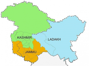
- Of the seven additional Assembly constituencies in the Union Territory, one each has been proposed in the districts of Kathua, Samba, Rajouri, Reasi, Doda and Kishtwar in the Jammu division, and Kupwara in the Kashmir valley. In a statement, the Commission said it has proposed carving out an additional constituency in some districts to balance the representation for geographical areas with inadequate communication and lack of public conveniences given their excessive remoteness or inhospitable conditions on the international border.
What is Delimitation?
- Delimitation is the act of redrawing boundaries of Lok Sabha and Assembly constituencies to represent changes in population and is done on the basis of the preceding Census.
- This exercise is carried out by a Delimitation Commission, whose orders have the force of law and can not be questioned before any court.
Aim: The key aim is to have equal representation to equal segments of the population in order to ensure a fair division of geographical areas so that all political parties or candidates contesting elections have a level playing field in terms of the number of voters.
Constitutional provisions:
- Article 82: This provides the Parliament with the authority to enact a Delimitation Act after every Census.
- Article 170: This provides for the States to get divided into territorial constituencies as per the Delimitation Act after every Census.
- The Union government sets up a Delimitation Commission once the Act is in force.
- Objective: To provide equal representation for equal population segments and a fair division of geographical areas so that no political party has an advantage
Delimitation Commission
- It is appointed by the President of India and works in collaboration with the Election Commission of India.
- Its members are a serving or retired Supreme Court judge, Chief Election Commissioner or an Election Commissioner nominated by CEC and Election Commissioners of the respective state.
- Its function is to determine the number and boundaries of constituencies, to identify seats reserved for SC/ST.
- It is a high-power body whose orders have the force of law and cannot be called in question before any court.
- Delimitation Commissions have been set up four times — 1952, 1963, 1973 and 2002 under the Acts of 1952, 1962, 1972 and 2002.
THE INTERNATIONAL RELATIONS
2. PANEX 21
THE CONTEXT: Recently, PANEX-21was held in Pune for Humanitarian Assistance and Disaster Relief Exercise is to be held among the BIMSTEC countries: Bhutan, Bangladesh, Nepal, Myanmar, Sri Lanka, India and Thailand. The main aim of the exercise is to build regional cooperation in responding to natural disasters.
About PANEX-21:
- It is a multinational disaster relief exercise.
- The exercise is to be held among the BIMSTEC countries: Bhutan, Bangladesh, Nepal, Myanmar, Sri Lanka, India and Thailand.
- The main aim of the exercise is to build regional cooperation in responding to natural disasters.
How will the exercise be conducted?
- The participants of the exercise will be divided into eight syndicates. One syndicate from the participating countries and two from India.
- It will analyse the capabilities of member states in responding to a natural disaster. The countries will share their best practices.
- The exercise will review the procedures of preparedness and response. It will then recommend the evolution of organized structure.
- During the exercise, the countries will discuss military–to–military cooperation protocol.
Why is the exercise important?
- Recently, the cyclones in the Bay of Bengal are becoming more disastrous. This is mainly due to climate change. The increase in surface sea temperature is making cyclones more powerful. The increase in sea–surface temperature increases the wind speeds of the cyclones. The devastation caused by Cyclone Amphan was 13 billion USD.
- The unplanned development in Ecological Sensitive Zones fails to address the risks posed by the increasing intense cyclones.
- For these reasons, it is essential to remain prepared. Therefore, there is a need for international cooperation among the coastal countries.
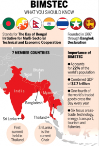
Why is BIMSTEC important for India?
As the region’s largest economy, India has a lot at stake.
- BIMSTEC connects not only South and Southeast Asia, but also the ecologies of the Great Himalayas and the Bay of Bengal.
- For India, it is a natural platform to fulfill our key foreign policy priorities of ‘Neighborhood First’ and ‘Act East.
- For New Delhi, one key reason for engagement is the vast potential that is unlocked with stronger connectivity. Almost 300 million people, or roughly one-quarter of India’s population, live in the four coastal states adjacent to the Bay of Bengal (Andhra Pradesh, Orissa, Tamil Nadu, and West Bengal).
- From the strategic perspective, the Bay of Bengal, a funnel to the Malacca straits, has emerged as a key theatre for an increasingly assertive China in maintaining its access route to the Indian Ocean.
- As China mounts assertive activities in the Bay of Bengal region, with increased submarine movement and ship visits in the Indian Ocean, it is in India’s interest to consolidate its internal engagement among the BIMSTEC countries.
THE ENVIRONMENT AND ECOLOGY
3. THE ADVERSE EFFECTS OF AIR POLLUTION
THE CONTEXT: According to the new report, India recorded 867,000 deaths in 2017 due to exposure to fine particulate matter (PM2.5) — the second highest in the world.
THE EXPLANATION:
- The study Global Burden of Disease from Major Air Pollution Sources: A Global Approach by Health Effects Institute (HEI), an independent, non-profit research institute was published December 15, 2021. It analysed data on air pollution and mortality from 1970-2017.
- China topped the list with 1,387,000 deaths. Indonesia came third, recording 94,000 deaths, followed by Egypt 88,000, Pakistan 86,000, Russian Federation 68,000, Bangladesh 64,000, Nigeria 51,000 and the United States 47.
- In India, the top four of the 200 areas with the highest PM2.5 concentrations — Singrauli, Kanpur, Sitapur and Ahmedabad — all experienced increase in population-weighted mean (PWM) for PM2.5 mass between 1970 and 2017 (the study period). The PWM for these places was 14-16 times the annual average advocated in World Health Organization guidelines.
Major Pollutants:
- Fossil fuels are a major source of PM2.5 emissions that are trapped in the atmosphere due to various atmospheric factors, past studies have established.
- Of the fossil fuels, coal contributed the most to global deaths associated with particulate matter emissions, the study found. “In India, coal accounted for 16 percent deaths linked to air pollution in 2015 and 17.1 percent in 2017.”
- Globally, the number of deaths associated with outdoor PM2.5 exposure was 2.07 million in 2017 and increased marginally to 09 million in 2019, the HEI study found.
- The burning of fossil fuels contributed to nearly 1.05 million deaths in 2017 worldwide, 800,000 of which were in South Asia or East Asia (32.5 percent of air pollution-related deaths in those regions), according to a new study.
- Coal combustion alone was responsible for half of those deaths, while natural gas and oil combustion were responsible for the other half, the study found.
- Other dominant global sources included residential, industrial and energy sectors, according to the report.
- Regions with large anthropogenic contributions generally had the highest attributable deaths, the findings showed.
- Complete elimination of coal in China and India could reduce the global PM2.5 disease burden by nearly 20 percent, the study suggested.
Value Addition:
What is PM 2.5 and PM 10?
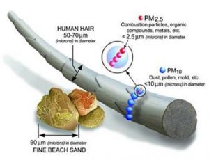
- PM is also called Particulate Matter or particle pollution, which is a mixture of solid particles and liquid droplets present in the atmosphere. The particles present in the air are so minute that you cannot even view them through naked eyes. Some particles are so small that they can only be detected by using an electron microscope. Particle pollution consists of PM2.5 and PM10 which are very dangerous.
- 5 refers to the atmospheric particulate matter that has a diameter of fewer than 2.5 micrometers, which is about 3% of the diameter of human hair.
Sources of Particulate Matter
- Particulate Matter is of different sizes, and it can be due to both human and natural sources. Sources can be primary and secondary.
- The primary source includes automobile emissions, dust and cooking smoke. The secondary source of pollution can be due to complex reactions of chemicals like Sulphur dioxide and nitrogen oxide.
- These particles are mixed in the air and pollute it. Apart from these, forest fires, wood-burning stoves, agricultural burning, the smoke of the industry, dust occurring from various construction sites also causes air pollution etc.
What are the health effects of PM2.5 and PM10?
- Problem in breathing
- Irritation in eyes, nose, and throat
- Tightness of the chest
- Lungs do not work properly
- Severe Respiratory diseases
- Irregular heartbeat etc.
Government Measurements:
- Introduction of cleaner gaseous fuels like CNG, LPG etc and ethanol blending.
- Banning of the burning of biomass.
- Promotion of public transport network.
- Pollution Under Control Certificate.
- Issuance of directions under Air (Prevention and Control of Pollution) Act, 1981.
- Installation of online continuous (24×7) monitoring devices by 17 highly polluting industrial sectors.
- Regulating the bursting of pollution-emitting crackers.
- Notification of graded response action plan for Delhi identifying source-wise actions for various levels of air pollution, etc.
- Leapfrogging from BS-IV to BS-VI standards for vehicles by 1st April 2020.
4. THE EXPANSION OF THE THAR DESERT
THE CONTEXT: The study was undertaken as part of an assessment of the environmentally sensitive areas within the framework of the UN Convention to Combat Desertification (UNCCD). The scientists associated with the project studied the climate and vegetation in Thar, which is the world’s ninth-largest hot subtropical desert, to understand the desertification process.
THE EXPLANATION:
- With these findings, a study on desertification of the Thar region conducted by the Central University of Rajasthan has predicted that the sandstorms from the desert will travel as far as the National Capital Region (NCR) in the years to come. The sandstorms will become intense with the erosion of the Aravali hills, which act as a ‘natural green wall’ between the desert and the plains.
- Along with the gradual destruction of the Aravali ranges, the mighty Thar desert in western Rajasthan is expanding fast because of the migration of people, changes in the rainfall pattern, spread of sand dunes and unscientific plantation drives. The degradation of land is posing a threat to the desert ecology, while climate change has contributed to the spread of arid regions.
LOSS OF ARAVALI’S
- According to the scientists, the loss of Aravali hills because of unchecked mining activities would result in sandstorms traveling to NCR and Delhi. “The suspended particles from the arid region are contributing to air pollution in NCR. The sandstorms will hit this area because of the desert expanding in the eastern direction”.
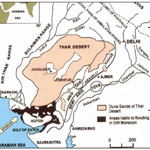
- The study, which focused on Barmer, Jaisalmer, Bikaner and Jodhpur districts covering more than 50% of Thar desert, found that Jodhpur, situated near the Aravali hills, had witnessed a slow speed of desertification. It also found that the vegetation cover and water bodies had increased in the area in the last 46 years and the complex sand region had decreased by 4.98%.
- According to CAZRI,(Central Arid Zone Research Institute), the biggest reason contributing to desertification turned out to be water erosion. Our report suggested that 64.69% of the mapped area is facing wind erosion. For instance, 10% of land degradation in districts like Barmer, Jaisalmer and Jodhpur is due to water erosion.
About the Thar Desert:
The Thar Desert is about 4.56% of the total geographic area of India. More than 60% of the desert lies in the Indian state of Rajasthan; the portion in India also extends into Gujarat, Punjab, and Haryana.
UN Convention to Combat Desertification (UNCCD):
- Established in 1994, the UNCCD is the only legally binding international agreement linking environment and development issues to the land agenda.
- Focus area:It addresses specifically the arid, semi-arid and dry sub-humid areas, known as the drylands, where some of the most vulnerable ecosystems and peoples can be found.
- 2006 was declared “International Year of Deserts and Desertification”.
- Its secretariat has been located in Bonn, Germany.
COP14
- The 14th edition of the Conference of Parties (COP-14) to the UN Convention to Combat Desertification (UNCCD) 2019. Held in Greater Noida, this was the first time that India hosted an edition of the UNCCD COP.
- The theme of the Conference was ‘Restore land, Sustain future’.
- India is the global host for COP 14 has taken over the COP Presidency from China for the next two years till 2021.
- India is among the select few countries to have hosted the COP of all three Rio conventions on climate change, biodiversity and land.
OUTCOMES:
Delhi Declaration: Commitment for a range of issues, including gender and health, ecosystem restoration, taking action on climate change, private sector engagement, Peace Forest Initiative and recovery of five million hectares of degraded land in India.
The country parties have agreed to make the Sustainable Development Goal target of achieving land degradation neutrality by 2030, a national target for action.
Peace Forest Initiative: It is an initiative of South Korea to use ecological restoration as a peace-building process. It aims at addressing the issue of land degradation in conflict-torn border areas and would go a long way in alleviating tensions and building trust between communities living there and between enemy countries in particular.
The Bonn Challenge is a global effort to bring 150 million hectares of the world’s deforested and degraded land under restoration by 2020, and 350 million hectares by 2030.
5. EXCESS RAIN AFFECTS BIRD MIGRATION TO KARNATAKA
THE CONTEXT: Heavy rains across Karnataka during October and November 2021 have affected the winter migration of birds that otherwise used to flock in large numbers and roost in the water bodies of the State before flying out again during the onset of summer.
THE EXPLANATION:
- According to ornithologists, they are witnessing a dispersal of bird population and the groups have scattered to different places in search of a more suitable habitat mainly marshy lands. Hence the bird count is low in the lakes that are full to the brim during this season”.
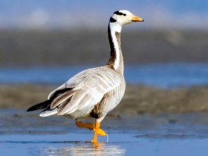
- The bar-headed Geese, which flies across the Himalayas from southern China and Mongolia, are yet to be sighted in large numbers either in Hadinaru near Nanjangud or Sira in Tumakuru.
- These birds tend to have a stopover in the wetlands around Vijayapura and the backwaters of Ghataprabha before heading towards the southern parts of Karnataka. Teals, pin-tailed ducks, Gargini, Coot, Sandpipers, common pochards are a few other species that roost in the State during winter.
- A majority of the winter migratory birds are waders and prefer the shallow and stagnant waters of a lake with hydrophytes or vegetation that draw insects and facilitate larvae formation.
- A stagnant and shallow pool provides a rich source of food for wading birds. But heavy rains and continuous inflow of water into lakes do not allow for their formation and this will benefit only the fish-eating birds, according to the bird watchers.
- Another scenario common across the State was the so-called lake development projects and use of excavators during desilting exercises which were forcing the birds to abandon such habitats.
6. INDIAN DESERT CAT SPOTTED IN PANNA TIGER RESERVE
THE CONTEXT: An Indian desert cat has been spotted for the first time in Madhya Pradesh’s Panna Tiger Reserve (PTR).
THE EXPLANATION:
- As the name suggests, this cat is found in deserts and can survive without water. The toes of the species have cushion-like hair which helps them balance the fluctuating desert temperatures.
- According to forest officials, the presence of this wild cat was not reported in the PTR’s records earlier.

About Indian Desert Cat
- It is a species of wild cat found in ‘Western India’. It is commonly seen in Rajasthan, Gujarat, Maharashtra and Madhya Pradesh. It lives in desert-shrub areas. It is also known as ‘Asian wild cat’.
- Their ears are large so that they can hear even low sounds. Their toes have hair-like cushions that allow it to adapt to the temperature fluctuations of the desert. This species can survive even without water.
- Their color is such that they can easily hide in the desert sand. They rest during the day and hunt small animals and birds during the night.
Threats and Conservation:
- Habitat destruction, breeding with domestic cats and poaching are major threats.
- This is protected under Schedule-I of the Indian Wildlife Protection Act, 1972 and included in the category of ‘Least Concern’ in the Red List of IUCN.
About Panna Tiger Reserve
- The Panna ‘National Park’ was initially set up in It only received the status of a tiger reserve in the early 1990s under “Project Tiger.”
- Once it had been converted into a tiger reserve, the population of tigers started to bloom.
- Panna Tiger Reserve spans 576 kilometers in the Panna and Chhatarpur districts of Madhya Pradesh.
- The Ministry of Environment, Forest and Climate Change (MoEFCC) declared Panna Tiger Reserve as a Biosphere Reserve in 2011.
- The thick deciduous forest of the Panna National Reserve is the natural habitat of sloth, Indian wolf, Bear Pangolin, Leopard, Gharial, Indian fox and a lot more. While visiting the park, tourists also get to witness stone carvings that date back to the Neolithic era.
- A report by the All-India Tiger Estimation made Madhya Pradesh the state with the highest number of tigers.
- The state had a total of 526 big cats according to the 2018 census. After Madhya Pradesh, Karnataka and Uttarakhand have the highest number of tigers.
UNESCO on Panna Biosphere Reserve
- UNESCO’s recognition mentioned Panna Tiger Reserve as a critical tiger habitat.
- It stated that the area has undergone substantial ecosystem restoration in the buffer zone.
- With only three urban centers and over 300 villages, agriculture is the main source of income here, together with horticulture, forestry and cultural and eco-tourism.
THE PRELIM PRACTICE QUESTION
Q1. Consider the following statements about OIC:
- It was established in September 1969.
- Its headquarter is in Riyadh, Saudi Arabia.
- India is not a member of OIC.
Which of the above statements is/are correct?
a) 1 only
b) 2 and 3 only
c) 1 and 3 only
d) All of them
FOR 19TH DECEMBER 2021 PRELIMS PRACTICE QUESTIONS
Answer: A)
Explanation:
- Please refer to the given map