THE CONTEXT: Recent statements by the Chief Minister of Assam dismissed fears that Chinese dams could “switch off” the Brahmaputra, arguing that 65-70 percent of the river’s annual flow is generated inside India. This has revived questions about upstream Chinese projects such as the proposed 60 GW Medog (Motuo) dam on the Yarlung Tsangpo and their actual impact on floods and water security in Assam and Arunachal Pradesh.
THE BACKGROUND:
-
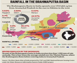
- The Brahmaputra basin inside India covers 94 lakh km² (34 percent of total area) but contributes > 80 percent of runoff, because the Indian reach receives an average 2 371 mm of monsoon rain while Tibet averages only ~300 mm.
- The river, called Yarlung Tsangpo in Tibet and Siang in Arunachal Pradesh, gains several major tributaries (Subansiri, Lohit, Dibang, Manas, Teesta) before entering Bangladesh as the Jamuna.
- It carries about 30 percent of India’s usable surface water and 41 percent of the national hydropower potential.
THEORETICAL FRAMEWORK:
-
- Hydro-hegemony: an upstream state can exert strategic influence by controlling water flows.
-
- The Limited Territorial Integrity principle (1997 UN Watercourses Convention) insists on “no significant harm”, whereas China leans towards Absolute Territorial Sovereignty.
- Complex adaptive river systems: monsoon rainfall, not glacial melt, shapes > 85 percent of annual discharge; hence, storage-centric fears may be overstated.
WHAT / WHY / HOW:
| Aspect | Explanation |
|---|---|
| What is China building? | A run-of-river cascade (510 MW Zangmu plus four smaller plants) already operational, and the Medog dam now approved, exploiting a 2 000 m head at the Great Bend. |
| Why is China doing it? | Grid decarbonisation targets, poverty alleviation in Tibet Autonomous Region, and strategic leverage, including a possible long-term South-North Water Diversion (Western Route). |
| How could it affect India? | Storage volumes are too small to cut India’s wet-season flow, but risks arise from sudden peaking releases, dam-break floods, sediment starvation and lean-season variability. |
TECHNICAL DETAILS:
| Project / Mechanism | Key Specs | Likely Downstream Impact |
|---|---|---|
| Medog dam (China) | 60 GW; < 10 percent live storage of monthly Brahmaputra flow | Low depletion; possible flash-flood risk if gates fail |
| Upper Siang project (India) | 11 GW; 9 BCM live storage | Flood moderation buffer, peak-hour power |
| Sino-Indian data MoUs (2002-2018) | Daily flow levels at three stations (15 May-15 Oct) | Helps Assam flood warning; needs expansion to sediment data |
CURRENT SCENARIO & SIGNIFICANCE:
-
- Flood paradox: Discharge multiplies sixfold between Tuting (Arunachal) and Pandu (Assam), causing annual embankment breaches and erosion of ~8,000 ha.
- Economic stakes: The North-East power vision banks on 30 GW by 2032; National Waterway-2 and the “Act East” corridor demand stable river morphology.
DRIVERS OF VULNERABILITY:
1. Climate volatility — stronger “atmospheric river” rain events.
2. High seismicity — landslide dams and potential dam-break surges.
3. Data gaps — China’s occasional suspension of hydrological data (e.g., 2017 Doklam episode).
INDIAN POLICY LANDSCAPE:
-
- Brahmaputra Board (1981) → North-East Water Management Authority Bill 2023 (pending).
- National Hydrology Project (World Bank + DoWR, ₹ 3 640 crore): real-time sensors & flood forecasting.
- Act East through North-East Policy, PM-DevINE fund, and River Basin Management Bill 2022 (inter-state commissions).
GLOBAL & REGIONAL BENCHMARKS:
-
- Mekong River Commission (data-driven cooperative model).
- Indus Waters Treaty resilience lessons: third-party dispute boards, arbitration triggers, flood-season warnings.
- UN Watercourses Convention 1997 tools: “no significant harm”, equitable use, prior notification.
THE CHALLENGES:
| CHALLENGES | EXPLANATION |
|---|---|
| Hydro-Secrecy & Data Asymmetry | • China stopped transmitting Brahmaputra gauge data for five months during the 2017 Doklam stand-off, crippling Assam’s flood forecasting; Bangladesh, however, kept receiving the feed, exposing a power asymmetry. • Current Sino-Indian MoUs cover only daily water levels at three upper-Tibet stations (15 May-15 Oct) and provide no bathymetric, sediment, snow-melt or gate-operation data, violating the “no-significant-harm” norm of the 1997 United Nations Watercourses Convention, which India has not yet ratified. |
| Geomorphic Fragility & Sediment Overload | • Assam officially loses ≈ 8 000 ha of land every year to bank erosion; the river widens to 15 km in places. • The Brahmaputra–Ganga system delivers 0.5–1.1 billion tonnes of silt annually, one of the world’s highest loads, jeopardising National Waterway-2 and reservoir storage. • Majuli, once 1 250 km², has shrunk to ≈ 483 km² by 2014, threatening cultural landscapes and tourism. |
| Climate-Induced Hydro-Variability | • IPCC-AR6 projects intensified “atmospheric-river” events over the Eastern Himalaya; CMIP-6 models foresee up to 45 % rise in dry-season flow and 42 % in wet-season flow by 2050, amplifying both drought and flood risk. • The Council on Energy, Environment, and Water’s district-level Climate Vulnerability Index flags all eight Northeastern states in the top flood-risk decile. |
| Socio-Ecological Strain of Mega-Dams | • The 11 000 MW Upper Siang project alone may displace > 20 000 tribal residents and submerge elephant corridors in Dibang Valley. • Lower Subansiri protests highlight livelihood loss for 6 lakh people and threats to the only resident population of the Gangetic River dolphin in a Brahmaputra tributary. • IUCN scientists warn cumulative dams could extirpate river dolphins from the basin |
| Institutional Fragmentation & Governance Vacuum | • Four overlapping entities—Central Water Commission, Brahmaputra Board, State Water Resources Departments and National Disaster Management Authority—create a coordination maze, as flagged by the 2016 Mihir Shah Committee on water governance. • The proposed North-East Water Management Authority (NEWMA) meant to replace the Brahmaputra Board, still awaits Cabinet approval, stalling integrated basin management. |
| Knowledge & Modelling Gaps | • Only 33 real-time hydromet stations across a 5.8-lakh-km² transboundary basin; lack of high-resolution bathymetry hampers Probable Maximum Flood (PMF) design for critical dams—an issue flagged after the 2021 Chamoli glacier burst (although in a different basin). |
THE WAY FORWARD:
-
- Treaty-grade Data Protocol: Negotiate an upgraded Sino-Indian “Brahmaputra Water Information Agreement” with near-real-time telemetry, sediment flux and gate-release logs. Use ISRO-CWC joint apps to validate data integrity.
- Strategic Multi-purpose Storage: Fast-track Upper Siang, Dibang and Subansiri reservoirs with environmental flow clauses and fish lifts. Their 15 BCM combined capacity can shave > 30 percent of Assam’s peak flood volumes and store lean-season power head. Integrate pumped-storage modules for grid-balancing.
- Room-for-the-River Zoning: Notify flood-plain zoning rules under the Disaster Management Act; incentivise states through the Fifteenth Finance Commission’s performance grants. Restore 1 000 km² of wetlands (beels, haors) as natural sponges in five years.
- Eco-Engineering of Embankments: Replace earthen dykes with geo-bags and vegetative revetments; pilot “living levees” using vetiver & bamboo—cut seepage by 35 percent and create livelihood niches.
- Hydro-diplomacy Diversification: Institutionalize a Brahmaputra Track-II forum (academia-state-PLA retired officers); parallelly utilize the BIMSTEC Water Forum to build downstream solidarity with Bangladesh and Bhutan, thereby diluting zero-sum narratives.
- Ratification of UNWC 1997 & Helsinki Accession: India’s accession would strengthen its legal standing, pressuring China through normative power while showcasing India’s water-diplomacy credentials.
THE CONCLUSION:
The Brahmaputra story is less a tale of upstream hydro-coercion and more of downstream adaptive capacity. A calibrated mix of science-based diplomacy, climate-proofed infrastructure, and participatory basin governance can turn the so-called “Chinese dam threat” into a catalyst for North-east India’s blue-green renaissance.
UPSC PAST YEAR QUESTION:
Q. Distinguish a run-of-river hydropower project from a storage dam. Examine their relative merits and de-merits in the Himalayan context. 2016
MAINS PRACTICE QUESTION:
Q. While Chinese mega-dams on the Yarlung Tsangpo are often portrayed as an existential threat, the real challenge for India lies within its management of the Brahmaputra basin. Analyse.
SOURCE:
Spread the Word