Day-769
Quiz-summary
0 of 20 questions completed
Questions:
- 1
- 2
- 3
- 4
- 5
- 6
- 7
- 8
- 9
- 10
- 11
- 12
- 13
- 14
- 15
- 16
- 17
- 18
- 19
- 20
Information
DAILY MCQ
You have already completed the quiz before. Hence you can not start it again.
Quiz is loading...
You must sign in or sign up to start the quiz.
You have to finish following quiz, to start this quiz:
Results
0 of 20 questions answered correctly
Your time:
Time has elapsed
You have reached 0 of 0 points, (0)
Categories
- Not categorized 0%
- 1
- 2
- 3
- 4
- 5
- 6
- 7
- 8
- 9
- 10
- 11
- 12
- 13
- 14
- 15
- 16
- 17
- 18
- 19
- 20
- Answered
- Review
-
Question 1 of 20
1. Question
Consider the following pairs:
Connectivity project – Regions connected
1. North-South corridor – Srinagar to Thiruvananthapuram
2. East-West corridor – Porbandar to Imphal
3. Atal Tunnel – Manali to Lahual-Spiti valley
How many of the above pairs are correctly matched?Correct
Answer. A
Explanation- National Highways Authority of India (NHAI) undertook the following projects in the country:
● Golden Quadrilateral: It comprises construction of 5,846 km long 46 lane, high density traffic corridor to connect India’s four metropolitan cities (Delhi-Mumbai-Chennai-Kolkata).
● North-South corridor: It aims at connecting Srinagar in Jammu and Kashmir with Kanyakumari in Tamil Nadu (including Kochi-Salem Spur) with 4,076 km long road.
● East-West corridor: It aims at connecting Silchar in Assam with the port town of Porbandar in Gujarat with 3,640 km of road length.
Connectivity project – Regions connected
North-South corridor – Srinagar to Kanyakumari
East-West corridor – Porbandar to Silchar
Atal Tunnel – Manali to Lahual-Spiti valley
Atal tunnel: The World’s longest Highway tunnel-Atal Tunnel (9.02 Km) has been built by Border Road Organisation. This tunnel connects Manali to Lahul-Spiti valley throughout the year. Earlier the valley was cut off for about 6 months each year owing to heavy snowfall. The tunnel is built with ultra-modern specifications in the Pir Panjal range of Himalayas at an altitude of 3000 metres from the Mean Sea Level (MSL).
Source- NCERT Class 10 Contemporary India, NCERT Class 12 India-People and EconomyIncorrect
Answer. A
Explanation- National Highways Authority of India (NHAI) undertook the following projects in the country:
● Golden Quadrilateral: It comprises construction of 5,846 km long 46 lane, high density traffic corridor to connect India’s four metropolitan cities (Delhi-Mumbai-Chennai-Kolkata).
● North-South corridor: It aims at connecting Srinagar in Jammu and Kashmir with Kanyakumari in Tamil Nadu (including Kochi-Salem Spur) with 4,076 km long road.
● East-West corridor: It aims at connecting Silchar in Assam with the port town of Porbandar in Gujarat with 3,640 km of road length.
Connectivity project – Regions connected
North-South corridor – Srinagar to Kanyakumari
East-West corridor – Porbandar to Silchar
Atal Tunnel – Manali to Lahual-Spiti valley
Atal tunnel: The World’s longest Highway tunnel-Atal Tunnel (9.02 Km) has been built by Border Road Organisation. This tunnel connects Manali to Lahul-Spiti valley throughout the year. Earlier the valley was cut off for about 6 months each year owing to heavy snowfall. The tunnel is built with ultra-modern specifications in the Pir Panjal range of Himalayas at an altitude of 3000 metres from the Mean Sea Level (MSL).
Source- NCERT Class 10 Contemporary India, NCERT Class 12 India-People and Economy -
Question 2 of 20
2. Question
In the context of Indian railways, which of the following statements is not correct?
Correct
Answer. C
Explanation-
Statement 1 is correct- Indian Railways is the largest government undertaking in the country. The length of Indian Railways network was 67,956 km (Railway yearbook 2019-20). Its very large size puts a lot of pressure on a centralised railway management system. Thus, in India, the railway system has been divided into 19 zones.
Statement 2 is correct- The distance between rails in broad gauge is 1.676 metre. The total length of broad-gauge lines was 63950 km (2019-20).
Statement 3 is incorrect- The distance between rails in metre gauge is one metre. Its total length was 2402 km (2019-20).
Narrow gauge: The distance between the rails in this case is 0.762 metre or 0.610 metre. The total length of narrow gauge was 1604 km (2019-20).
Statement 4 is correct- Narrow gauge is generally confined to hilly areas.
Source- NCERT Class 12 India-People and EconomyIncorrect
Answer. C
Explanation-
Statement 1 is correct- Indian Railways is the largest government undertaking in the country. The length of Indian Railways network was 67,956 km (Railway yearbook 2019-20). Its very large size puts a lot of pressure on a centralised railway management system. Thus, in India, the railway system has been divided into 19 zones.
Statement 2 is correct- The distance between rails in broad gauge is 1.676 metre. The total length of broad-gauge lines was 63950 km (2019-20).
Statement 3 is incorrect- The distance between rails in metre gauge is one metre. Its total length was 2402 km (2019-20).
Narrow gauge: The distance between the rails in this case is 0.762 metre or 0.610 metre. The total length of narrow gauge was 1604 km (2019-20).
Statement 4 is correct- Narrow gauge is generally confined to hilly areas.
Source- NCERT Class 12 India-People and Economy -
Question 3 of 20
3. Question
Consider the following pairs:
National waterway – River
1. National waterway 1 – Ganga
2. National waterway 3 – Brahmaputra
3. National waterway 4 – Godavari-Krishna
How many of the above pairs are correctly matched?Correct
Answer. B
Explanation- For the development, maintenance and regulation of national waterways in the country, the Inland Waterways Authority was set up in 1986.
National waterway 1 – Ganga
National waterway 2 – Brahmaputra
National waterway 3 – West coast canal
National waterway 4 – Godavari-Krishna
National waterway 5 – Brahmani, Matai
National waterway 6 – Barak
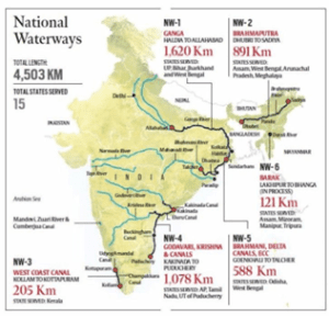
Source- Source- NCERT Class 12 India-People and Economy
Incorrect
Answer. B
Explanation- For the development, maintenance and regulation of national waterways in the country, the Inland Waterways Authority was set up in 1986.
National waterway 1 – Ganga
National waterway 2 – Brahmaputra
National waterway 3 – West coast canal
National waterway 4 – Godavari-Krishna
National waterway 5 – Brahmani, Matai
National waterway 6 – Barak
Source- Source- NCERT Class 12 India-People and Economy
-
Question 4 of 20
4. Question
Consider the following statements:
Statement I- The location of refineries in Barauni and Mathura is heavily influenced by pipelines.
Statement II- Pipelines can conveniently transport liquids, gases and solids over long distances.
Which one of the following is correct in respect of the above statements?Correct
Answer. A
Explanation- Pipeline transport network is a new arrival on the transportation map of India. In the past, these were used to transport water to cities and industries. Now, these are used for transporting crude oil, petroleum products and natural gas from oil and natural gas fields to refineries, fertilizer factories and big thermal power plants.
Statement 1 is correct- The far inland locations of refineries like Barauni, Mathura, Panipat and gas-based fertilizer plants could be thought of only because of pipelines. Therefore, pipelines heavily influence the location of such refineries in India.
Statement 2 is correct and explains statement 1- Pipelines are the most convenient and efficient mode of transporting liquids and gases over long distances. Even solids can also be transported by pipelines after converting them into slurry.
Source- NCERT Class 10 Contemporary India, NCERT Class 12 India-People and EconomyIncorrect
Answer. A
Explanation- Pipeline transport network is a new arrival on the transportation map of India. In the past, these were used to transport water to cities and industries. Now, these are used for transporting crude oil, petroleum products and natural gas from oil and natural gas fields to refineries, fertilizer factories and big thermal power plants.
Statement 1 is correct- The far inland locations of refineries like Barauni, Mathura, Panipat and gas-based fertilizer plants could be thought of only because of pipelines. Therefore, pipelines heavily influence the location of such refineries in India.
Statement 2 is correct and explains statement 1- Pipelines are the most convenient and efficient mode of transporting liquids and gases over long distances. Even solids can also be transported by pipelines after converting them into slurry.
Source- NCERT Class 10 Contemporary India, NCERT Class 12 India-People and Economy -
Question 5 of 20
5. Question
Consider the following statements:
1. 68 per cent of India’s trade by volume is moved by sea.
2. Deendayal port was the first port to be developed after independence.
3. Marmagao port is crucial for export of iron ore from the country.
How many of the above statements are correct?Correct
Answer. B
Explanation-
Statement 1 is incorrect- Oceanic routes play an important role in the transport sector of India’s economy. Approximately 95 per cent of India’s foreign trade by volume and 70 per cent by value moves through ocean routes.
Statement 2 is correct- Kandla in Kuchchh was the first port developed soon after Independence to ease the volume of trade on the Mumbai port, in the wake of loss of Karachi port to Pakistan after the Partition. Kandla also known as the Deendayal Port, is a tidal port. It caters to the convenient handling of exports and imports of highly productive granary and industrial belt stretching across UT of Jammu and Kashmir, and the states of Himachal Pradesh, Punjab, Haryana, Rajasthan and Gujarat.
Statement 3 is correct- Marmagao port (Goa) is the premier iron ore exporting port of the country. This port accounts for about fifty per cent of India’s iron ore exports.
Source- NCERT Class 10 Contemporary India, NCERT Class 12 India-People and EconomyIncorrect
Answer. B
Explanation-
Statement 1 is incorrect- Oceanic routes play an important role in the transport sector of India’s economy. Approximately 95 per cent of India’s foreign trade by volume and 70 per cent by value moves through ocean routes.
Statement 2 is correct- Kandla in Kuchchh was the first port developed soon after Independence to ease the volume of trade on the Mumbai port, in the wake of loss of Karachi port to Pakistan after the Partition. Kandla also known as the Deendayal Port, is a tidal port. It caters to the convenient handling of exports and imports of highly productive granary and industrial belt stretching across UT of Jammu and Kashmir, and the states of Himachal Pradesh, Punjab, Haryana, Rajasthan and Gujarat.
Statement 3 is correct- Marmagao port (Goa) is the premier iron ore exporting port of the country. This port accounts for about fifty per cent of India’s iron ore exports.
Source- NCERT Class 10 Contemporary India, NCERT Class 12 India-People and Economy -
Question 6 of 20
6. Question
Consider the following statements about ports of India:
1. India has twelve major ports.
2. Kolkata port is the only riverine port in the country.
3. Tuticorin port is the largest natural port of India.
Which of the statements given above is/are correct?Correct
Answer. B
Explanation-
Statement 1 is incorrect- India has 13 major ports and about 205 notified minor and intermediate ports.
Name of major port – State/UT in which it is located
1. Chennai – Tamil Nadu
2. Kochi – Kerala
3. Ennore – Tamil Nadu
4. Kolkata – West Bengal
5. Kandla – Gujarat
6. Mangalore – Karnataka
7. Marmugao – Goa
8. Mumbai Port Trust – Maharashtra
9. Nhava Sheva – Maharashtra
10. Paradip – Odisha
11. Tuticorin – Tamil Nadu
12. Vishakhapatnam – Andhra Pradesh
13. Port Blair – Andaman and Nicobar IslandsStatement 2 is correct- Kolkata port is the only riverine port in the country. It is built over the river Hoogly and is also known as Diamond Harbour.
Kolkata is an inland riverine port. This port serves a very large and rich hinterland of Ganga-Brahmaputra basin. Being a tidal port, it requires constant dredging of Hoogly.
Statement 3 is incorrect- Mumbai port is the largest natural port of India.
Source- NCERT Class 10 Contemporary India, NCERT Class 12 India-People and Economy, PIBIncorrect
Answer. B
Explanation-
Statement 1 is incorrect- India has 13 major ports and about 205 notified minor and intermediate ports.
Name of major port – State/UT in which it is located
1. Chennai – Tamil Nadu
2. Kochi – Kerala
3. Ennore – Tamil Nadu
4. Kolkata – West Bengal
5. Kandla – Gujarat
6. Mangalore – Karnataka
7. Marmugao – Goa
8. Mumbai Port Trust – Maharashtra
9. Nhava Sheva – Maharashtra
10. Paradip – Odisha
11. Tuticorin – Tamil Nadu
12. Vishakhapatnam – Andhra Pradesh
13. Port Blair – Andaman and Nicobar IslandsStatement 2 is correct- Kolkata port is the only riverine port in the country. It is built over the river Hoogly and is also known as Diamond Harbour.
Kolkata is an inland riverine port. This port serves a very large and rich hinterland of Ganga-Brahmaputra basin. Being a tidal port, it requires constant dredging of Hoogly.
Statement 3 is incorrect- Mumbai port is the largest natural port of India.
Source- NCERT Class 10 Contemporary India, NCERT Class 12 India-People and Economy, PIB -
Question 7 of 20
7. Question
Consider the following statements:
1. Radio broadcasting started in India in 1923.
2. The INSAT satellites are useful for telecommunications only.
Which of the statements given above is/are correct?Correct
Answer. A
Explanation-
Statement 1 is correct- Radio broadcasting started in India in 1923 by the Radio Club of Bombay. Since then, it gained immense popularity and changed the socio-cultural life of people.
Statement 2 is incorrect- On the basis of configuration and purposes, satellite system in India can be grouped into two: Indian National Satellite System (INSAT) and Indian Remote Sensing Satellite System (IRS). The INSAT, which was established in 1983, is a multi-purpose satellite system for telecommunication, meteorological observation and for various other data and programmes.
The IRS satellite system became operational with the launching of IRS-IA in March 1988 from Vaikanour in Russia.
Source- NCERT Class 12 India-People and EconomyIncorrect
Answer. A
Explanation-
Statement 1 is correct- Radio broadcasting started in India in 1923 by the Radio Club of Bombay. Since then, it gained immense popularity and changed the socio-cultural life of people.
Statement 2 is incorrect- On the basis of configuration and purposes, satellite system in India can be grouped into two: Indian National Satellite System (INSAT) and Indian Remote Sensing Satellite System (IRS). The INSAT, which was established in 1983, is a multi-purpose satellite system for telecommunication, meteorological observation and for various other data and programmes.
The IRS satellite system became operational with the launching of IRS-IA in March 1988 from Vaikanour in Russia.
Source- NCERT Class 12 India-People and Economy -
Question 8 of 20
8. Question
Consider the following ports of India:
1. Mumbai port
2. Vishakhapatnam port
3. Chennai port
4. Marmagao port
How many of the above ports of India are natural harbours?Correct
Answer. C
Explanation- The following ports in India are natural harbours:
● Mumbai port
● Marmagao port
● Kochchi port
● Vishakhapatnam port
Chennai port is one of the oldest ports on the eastern coast. It is an artificial harbour built in 1859.
Source- NCERT Class 12 India-People and EconomyIncorrect
Answer. C
Explanation- The following ports in India are natural harbours:
● Mumbai port
● Marmagao port
● Kochchi port
● Vishakhapatnam port
Chennai port is one of the oldest ports on the eastern coast. It is an artificial harbour built in 1859.
Source- NCERT Class 12 India-People and Economy -
Question 9 of 20
9. Question
Read the following description carefully:
“It is a land-locked harbour, connected to the sea by a channel cut through solid rock and sand. An outer harbour has been developed for handling iron ore, petroleum and general cargo. It is situated on the eastern coast of India.”
Identify the port based on the description given above:Correct
Answer. D
Explanation- Vishakhapatnam is the deepest landlocked and well-protected port. This port was, originally, conceived as an outlet for iron ore exports.
Visakhapatnam Port in Andhra Pradesh is a land-locked harbour, connected to the sea by a channel cut through solid rock and sand. An outer harbour has been developed for handling iron-ore, petroleum and general cargo. Andhra Pradesh and Telangana are the main hinterland for this port.
Source- NCERT Class 10 Contemporary India, NCERT Class 12 India-People and EconomyIncorrect
Answer. D
Explanation- Vishakhapatnam is the deepest landlocked and well-protected port. This port was, originally, conceived as an outlet for iron ore exports.
Visakhapatnam Port in Andhra Pradesh is a land-locked harbour, connected to the sea by a channel cut through solid rock and sand. An outer harbour has been developed for handling iron-ore, petroleum and general cargo. Andhra Pradesh and Telangana are the main hinterland for this port.
Source- NCERT Class 10 Contemporary India, NCERT Class 12 India-People and Economy -
Question 10 of 20
10. Question
Consider the following statements about Marmagao port:
1. Marmagao port is situated on Zuari estuary.
2. It handles the export of iron ore from India to Japan.
3. It is the deepest port of India.
How many of the above statements are correct?Correct
Answer. B
Explanation- Marmagao port is located on the western coast of India in the state of Goa. It is a natural port and among the oldest ports of India.
Statement 1 is correct- Marmagao Port, situated at the entrance of the Zuari estuary, is a natural harbour in Goa.
Statement 2 is correct- It gained significance after its remodelling in 1961 to handle iron-ore exports to Japan. Construction of Konkan railway has considerably extended the hinterland of this port. Karnataka, Goa, Southern Maharashtra constitute its hinterland.
Statement 3 is incorrect- Paradwip Port is situated in the Mahanadi delta, about 100 km from Cuttack. It has the deepest harbour especially suited to handle very large vessels. It has been developed mainly to handle large-scale export of iron-ore. Odisha, Chhattisgarh and Jharkhand are the parts of its hinterland.
Source- NCERT Class 12 India-People and EconomyIncorrect
Answer. B
Explanation- Marmagao port is located on the western coast of India in the state of Goa. It is a natural port and among the oldest ports of India.
Statement 1 is correct- Marmagao Port, situated at the entrance of the Zuari estuary, is a natural harbour in Goa.
Statement 2 is correct- It gained significance after its remodelling in 1961 to handle iron-ore exports to Japan. Construction of Konkan railway has considerably extended the hinterland of this port. Karnataka, Goa, Southern Maharashtra constitute its hinterland.
Statement 3 is incorrect- Paradwip Port is situated in the Mahanadi delta, about 100 km from Cuttack. It has the deepest harbour especially suited to handle very large vessels. It has been developed mainly to handle large-scale export of iron-ore. Odisha, Chhattisgarh and Jharkhand are the parts of its hinterland.
Source- NCERT Class 12 India-People and Economy -
Question 11 of 20
11. Question
The Gaddi tribes are renowned for the practice of transhumance. Consider the following states in the context of their habitation-
1. Himachal Pradesh
2. Jammu and Kashmir
3. Sikkim
In how many of the above states of India are the Gaddi tribes found?Correct
Answer. B
Explanation- Bharmaur is inhabited by ‘Gaddi’, a tribal community who have maintained a distinct identity in the Himalayan region as they practised transhumance and conversed through Gaddiali dialect.
Gaddis are nomadic tribes which inhabit the states of Himachal Pradesh and Jammu and Kashmir in India. Historically, the Gaddis have experienced geographical and political isolation and socio-economic deprivation. The economy is largely based on agriculture and allied activities such as sheep and goat rearing. The process of development of tribal area of Bharmaur started in 1970s when Gaddis were included among ‘scheduled tribes.
Source- NCERT Class 12 India-People and EconomyIncorrect
Answer. B
Explanation- Bharmaur is inhabited by ‘Gaddi’, a tribal community who have maintained a distinct identity in the Himalayan region as they practised transhumance and conversed through Gaddiali dialect.
Gaddis are nomadic tribes which inhabit the states of Himachal Pradesh and Jammu and Kashmir in India. Historically, the Gaddis have experienced geographical and political isolation and socio-economic deprivation. The economy is largely based on agriculture and allied activities such as sheep and goat rearing. The process of development of tribal area of Bharmaur started in 1970s when Gaddis were included among ‘scheduled tribes.
Source- NCERT Class 12 India-People and Economy -
Question 12 of 20
12. Question
Consider the following:
1. The Population Bomb
2. Small is Beautiful
3. The Limits to Growth
4. Our Common Future
How many of the above publications have echoed the concept of sustainable development?Correct
Answer. D
Explanation-
All the above-mentioned publications deal with the concept of sustainable development.
The notion of sustainable development emerged in the wake of general rise in the awareness of environmental issues in the late 1960s in Western World. It reflected the concern of people about undesirable effects of industrial development on the environment. The publication of ‘The Population Bomb’ by Ehrlich in 1968 and ‘The Limits to Growth’ by Meadows and others in 1972 further raised the level of fear among environmentalists in particular and people in general. This sets the scenario for the emergence of new models of development under a broad phrase ‘sustainable development.’ Concerned with the growing opinion of world community on the environmental issues, the United Nations established a World Commission on Environment and Development (WCED) headed by the Norwegian Prime Minister Gro Harlem Brundtland. The Commission gave its report (also known as Brundtland Report) entitled ‘Our Common Future’ in 1987.
‘Small is Beautiful’ authored and published by Schumacher in 1974 reflects the Gandhian philosophy on the conservation of resources and the need for environmental protection.
Source- NCERT Class 12 India-People and EconomyIncorrect
Answer. D
Explanation-
All the above-mentioned publications deal with the concept of sustainable development.
The notion of sustainable development emerged in the wake of general rise in the awareness of environmental issues in the late 1960s in Western World. It reflected the concern of people about undesirable effects of industrial development on the environment. The publication of ‘The Population Bomb’ by Ehrlich in 1968 and ‘The Limits to Growth’ by Meadows and others in 1972 further raised the level of fear among environmentalists in particular and people in general. This sets the scenario for the emergence of new models of development under a broad phrase ‘sustainable development.’ Concerned with the growing opinion of world community on the environmental issues, the United Nations established a World Commission on Environment and Development (WCED) headed by the Norwegian Prime Minister Gro Harlem Brundtland. The Commission gave its report (also known as Brundtland Report) entitled ‘Our Common Future’ in 1987.
‘Small is Beautiful’ authored and published by Schumacher in 1974 reflects the Gandhian philosophy on the conservation of resources and the need for environmental protection.
Source- NCERT Class 12 India-People and Economy -
Question 13 of 20
13. Question
Consider the following:
1. Increase in cropping intensity
2. Reduction in erosion of soil
3. Reduction in soil salinity
4. Changes in the cropping pattern
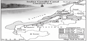
How many of the above are the impacts of the Indira Gandhi Canal Command Area Programme?Correct
Answer. C
Explanation- Indira Gandhi Canal, previously known as the Rajasthan Canal, is one of the largest canal systems in India. Conceived by Kanwar Sain in 1948, the canal project was launched on 31 March, 1958. The canal originates at Harike barrage in Punjab and runs parallel to Pakistan border at an average distance of 40 km in Thar Desert (Marusthali) of Rajasthan.

It has influenced the environmental conditions of the region both positively as well as negatively.
Option 2 is correct- Reduction in soil erosion: The availability of soil moisture for a longer period of time and various afforestation and pasture development programmes under CAD have resulted in greening the land. This has also helped in reducing wind erosion and siltation of canal systems.
Introduction of canal irrigation has brought about a perceptible transformation in the agricultural economy of the region. Soil moisture has been a limiting factor in successful growing of crops in this area.
Option 1 is correct- Increase in cropping intensity: Spread of canal irrigation has led to increase in cultivated area and intensity of cropping.
Option 4 is correct- Changes in cropping pattern: The traditional crops sown in the area, gram, bajra and jowar have been replaced by wheat, cotton, groundnut and rice. This is the result of intensive irrigation. This intensive irrigation, no doubt, initially has led to tremendous increase in agricultural and livestock productivity.
Option 3 is incorrect- Increase in Soil salinity: But the intensive irrigation and excessive use of water has led to the emergence of twin environmental problems of waterlogging and soil salinity.
The intensive irrigation has also caused waterlogging and soil salinity, and thus, in the long run, it hampers the sustainability of agriculture.
Source- NCERT Class 12 India-People and EconomyIncorrect
Answer. C
Explanation- Indira Gandhi Canal, previously known as the Rajasthan Canal, is one of the largest canal systems in India. Conceived by Kanwar Sain in 1948, the canal project was launched on 31 March, 1958. The canal originates at Harike barrage in Punjab and runs parallel to Pakistan border at an average distance of 40 km in Thar Desert (Marusthali) of Rajasthan.
It has influenced the environmental conditions of the region both positively as well as negatively.
Option 2 is correct- Reduction in soil erosion: The availability of soil moisture for a longer period of time and various afforestation and pasture development programmes under CAD have resulted in greening the land. This has also helped in reducing wind erosion and siltation of canal systems.
Introduction of canal irrigation has brought about a perceptible transformation in the agricultural economy of the region. Soil moisture has been a limiting factor in successful growing of crops in this area.
Option 1 is correct- Increase in cropping intensity: Spread of canal irrigation has led to increase in cultivated area and intensity of cropping.
Option 4 is correct- Changes in cropping pattern: The traditional crops sown in the area, gram, bajra and jowar have been replaced by wheat, cotton, groundnut and rice. This is the result of intensive irrigation. This intensive irrigation, no doubt, initially has led to tremendous increase in agricultural and livestock productivity.
Option 3 is incorrect- Increase in Soil salinity: But the intensive irrigation and excessive use of water has led to the emergence of twin environmental problems of waterlogging and soil salinity.
The intensive irrigation has also caused waterlogging and soil salinity, and thus, in the long run, it hampers the sustainability of agriculture.
Source- NCERT Class 12 India-People and Economy -
Question 14 of 20
14. Question
Consider the following statements:
1. Culturable wasteland is left fallow for over a year.
2. The culturable waste land is completely unfit for agriculture.
Which of the statements given above is/are correct?Correct
Answer. D
Explanation-
Statement 1 is incorrect- Any land which is left fallow (uncultivated) for more than five years is included in the category of Culturable Wasteland.
Fallow other than Current Fallow: This is a cultivable land which is left uncultivated for more than a year but less than five years.
Statement 2 is incorrect- The Culturable Wasteland can be brought under cultivation after improving it through reclamation practices. The increase in the net sown area is a recent phenomenon due to the use of culturable wasteland for agricultural purpose.
Source- NCERT Class 12 India-People and EconomyIncorrect
Answer. D
Explanation-
Statement 1 is incorrect- Any land which is left fallow (uncultivated) for more than five years is included in the category of Culturable Wasteland.
Fallow other than Current Fallow: This is a cultivable land which is left uncultivated for more than a year but less than five years.
Statement 2 is incorrect- The Culturable Wasteland can be brought under cultivation after improving it through reclamation practices. The increase in the net sown area is a recent phenomenon due to the use of culturable wasteland for agricultural purpose.
Source- NCERT Class 12 India-People and Economy -
Question 15 of 20
15. Question
Consider the following crops:
1. Bajra
2. Tur
3. Sugarcane
How many of the above crops are cultivated as kharif crops in India?Correct
Answer. C
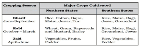
Explanation- There are three distinct crop seasons in the northern and interior parts of country, namely kharif, rabi and zaid.
Options 1, 2 and 3 are correct- The kharif season largely coincides with Southwest Monsoon under which the cultivation of tropical crops, such as rice, cotton, jute, jowar, bajra, sugarcane and tur is possible.
Source- NCERT Class 12 India-People and EconomyIncorrect
Answer. C
Explanation- There are three distinct crop seasons in the northern and interior parts of country, namely kharif, rabi and zaid.
Options 1, 2 and 3 are correct- The kharif season largely coincides with Southwest Monsoon under which the cultivation of tropical crops, such as rice, cotton, jute, jowar, bajra, sugarcane and tur is possible.
Source- NCERT Class 12 India-People and Economy -
Question 16 of 20
16. Question
Consider the following statements about agriculture in India:
1. Vegetables and fruits are mostly grown in zaid season.
2. Jowar and rice are the rabi crops of southern India.
Which of the statements given above is/are correct?Correct
Answer. C
Explanation-
Statement 1 is correct- Zaid is a short duration summer cropping season beginning after harvesting of rabi crops. The cultivation of watermelons, cucumbers, vegetables and fodder crops during this season is done on irrigated lands.
Statement 2 is correct- The rabi season begins with the onset of winter in October-November and ends in March-April. The low temperature conditions during this season facilitate the cultivation of temperate and subtropical crops such as wheat, gram and mustard.
Crops such as rice, maize, ragi, groundnut and jowar are the rabi crops of Southern States of India.
Source- NCERT Class 12 India-People and EconomyIncorrect
Answer. C
Explanation-
Statement 1 is correct- Zaid is a short duration summer cropping season beginning after harvesting of rabi crops. The cultivation of watermelons, cucumbers, vegetables and fodder crops during this season is done on irrigated lands.
Statement 2 is correct- The rabi season begins with the onset of winter in October-November and ends in March-April. The low temperature conditions during this season facilitate the cultivation of temperate and subtropical crops such as wheat, gram and mustard.
Crops such as rice, maize, ragi, groundnut and jowar are the rabi crops of Southern States of India.
Source- NCERT Class 12 India-People and Economy -
Question 17 of 20
17. Question
In the context of irrigation and its types, consider the following statements:
1. In case of protective irrigation, supplementary source of water is made available over and above the rainfall.
2. Productive irrigation ensures availability of soil moisture to the maximum possible area.
3. The water input per unit area of cultivated land is higher in case of protective irrigation.
How many of the above statements are correct?Correct
Answer. A
Explanation- On the basis of main source of moisture for crops, the farming can be classified as irrigated and rainfed (barani). There is difference in the nature of irrigated farming, as well as based on the objective of irrigation, i.e., protective or productive.
Statement 1 is correct- The objective of protective irrigation is to protect the crops from adverse effects of soil moisture deficiency which often means that irrigation acts as a supplementary source of water over and above the rainfall.
Statement 2 is incorrect- The strategy of protective irrigation is to provide soil moisture to maximum possible area.
Statement 3 is incorrect- Productive irrigation is meant to provide sufficient soil moisture in the cropping season to achieve high productivity. In such irrigation the water input per unit area of cultivated land is higher than protective irrigation.
Source- NCERT Class 12 India-People and EconomyIncorrect
Answer. A
Explanation- On the basis of main source of moisture for crops, the farming can be classified as irrigated and rainfed (barani). There is difference in the nature of irrigated farming, as well as based on the objective of irrigation, i.e., protective or productive.
Statement 1 is correct- The objective of protective irrigation is to protect the crops from adverse effects of soil moisture deficiency which often means that irrigation acts as a supplementary source of water over and above the rainfall.
Statement 2 is incorrect- The strategy of protective irrigation is to provide soil moisture to maximum possible area.
Statement 3 is incorrect- Productive irrigation is meant to provide sufficient soil moisture in the cropping season to achieve high productivity. In such irrigation the water input per unit area of cultivated land is higher than protective irrigation.
Source- NCERT Class 12 India-People and Economy -
Question 18 of 20
18. Question
Consider the following statements:
Statement I- Soil erosion is a common problem in regions under wetland farming.
Statement II- The regions under wetland farming receive annual rainfall higher than 75 cm.
Which one of the following is correct in respect of the above statements?Correct
Answer. A
Explanation- Rainfed farming is further classified on the basis of adequacy of soil moisture during cropping season into dryland and wetland farming. In India, the dryland farming is largely confined to the regions having annual rainfall less than 75 cm.
Statement 1 is correct and statement 2 correctly explains statement 1- In wetland farming, the rainfall is in excess of soil moisture requirement of plants during rainy season.
Such regions may face flood and soil erosion hazards. Rainfall received in regions under wetland farming is over 75 cm annually which causes the erosion of the soil.
These areas grow various water intensive crops such as rice, jute and sugarcane and practise aquaculture in the fresh water bodies.
Source- NCERT Class 12 India-People and EconomyIncorrect
Answer. A
Explanation- Rainfed farming is further classified on the basis of adequacy of soil moisture during cropping season into dryland and wetland farming. In India, the dryland farming is largely confined to the regions having annual rainfall less than 75 cm.
Statement 1 is correct and statement 2 correctly explains statement 1- In wetland farming, the rainfall is in excess of soil moisture requirement of plants during rainy season.
Such regions may face flood and soil erosion hazards. Rainfall received in regions under wetland farming is over 75 cm annually which causes the erosion of the soil.
These areas grow various water intensive crops such as rice, jute and sugarcane and practise aquaculture in the fresh water bodies.
Source- NCERT Class 12 India-People and Economy -
Question 19 of 20
19. Question
Consider the following pairs:
Local names of Jhumming – Regions
1. Dipa – Jharkhand
2. Pamlou – Manipur
3. Koman – Odisha
4. Kuruwa – Chattisgarh
How many of the above pairs are correctly matched?Correct
Answer. B
Explanation-In ‘slash and burn’ agriculture which is a type of primitive subsistence farming, farmers clear a patch of land and produce cereals and other food crops to sustain their family. When the soil fertility decreases, the farmers shift and clear a fresh patch of land for cultivation. This type of shifting allows nature to replenish the fertility of the soil through natural processes; land productivity in this type of agriculture is low as the farmer does not use fertilisers or other modern inputs.
It is known by different names in different parts of the country.
● Jhumming in north-eastern states like Assam, Meghalaya, Mizoram and Nagaland
● Pamlou in Manipur
● Dipa in Bastar district of Chhattishgarh, and in Andaman and Nicobar Islands
● ‘Bewar’ or ‘Dahiya’ in Madhya Pradesh
● ‘Podu’ or ‘Penda’ in Andhra Pradesh
● ‘Pama Dabi’ or ‘Koman’ or Bringa’ in Odisha
● ‘Kumari’ in Western Ghats
● ‘Valre’ or ‘Waltre’ in South-eastern Rajasthan
● ‘Khil’ in the Himalayan belt
● ‘Kuruwa’ in Jharkhand
The ‘slash and burn’ agriculture is known as ‘Milpa’ in Mexico and Central America, ‘Conuco’ in Venzuela, ‘Roca’ in Brazil, ‘Masole’ in Central Africa, ‘Ladang’ in Indonesia, ‘Ray’ in Vietnam.
Source- NCERT Class 10 Contemporary IndiaIncorrect
Answer. B
Explanation-In ‘slash and burn’ agriculture which is a type of primitive subsistence farming, farmers clear a patch of land and produce cereals and other food crops to sustain their family. When the soil fertility decreases, the farmers shift and clear a fresh patch of land for cultivation. This type of shifting allows nature to replenish the fertility of the soil through natural processes; land productivity in this type of agriculture is low as the farmer does not use fertilisers or other modern inputs.
It is known by different names in different parts of the country.
● Jhumming in north-eastern states like Assam, Meghalaya, Mizoram and Nagaland
● Pamlou in Manipur
● Dipa in Bastar district of Chhattishgarh, and in Andaman and Nicobar Islands
● ‘Bewar’ or ‘Dahiya’ in Madhya Pradesh
● ‘Podu’ or ‘Penda’ in Andhra Pradesh
● ‘Pama Dabi’ or ‘Koman’ or Bringa’ in Odisha
● ‘Kumari’ in Western Ghats
● ‘Valre’ or ‘Waltre’ in South-eastern Rajasthan
● ‘Khil’ in the Himalayan belt
● ‘Kuruwa’ in Jharkhand
The ‘slash and burn’ agriculture is known as ‘Milpa’ in Mexico and Central America, ‘Conuco’ in Venzuela, ‘Roca’ in Brazil, ‘Masole’ in Central Africa, ‘Ladang’ in Indonesia, ‘Ray’ in Vietnam.
Source- NCERT Class 10 Contemporary India -
Question 20 of 20
20. Question
Consider the following statements about cereals produced in India:
1. Nearly a quarter of the total cropped area in India is occupied by cereals.
2. Millets are coarse-grained cereals.
3. Punjab and Haryana are non-traditional rice-growing areas.
How many of the above statements are correct?Correct
Answer. B
Explanation-
Statement 1 is incorrect- The cereals occupy about 54 per cent of total cropped area in India.
Statement 2 is correct- India produces a variety of cereals, which are classified as fine grains (rice, wheat) and coarse grains (jowar, bajra, maize, ragi).
Statement 3 is correct- Punjab and Haryana are not traditional rice growing areas. Rice cultivation in the irrigated areas of Punjab and Haryana was introduced in 1970s following the Green Revolution.
Source- NCERT Class 12 India-People and EconomyIncorrect
Answer. B
Explanation-
Statement 1 is incorrect- The cereals occupy about 54 per cent of total cropped area in India.
Statement 2 is correct- India produces a variety of cereals, which are classified as fine grains (rice, wheat) and coarse grains (jowar, bajra, maize, ragi).
Statement 3 is correct- Punjab and Haryana are not traditional rice growing areas. Rice cultivation in the irrigated areas of Punjab and Haryana was introduced in 1970s following the Green Revolution.
Source- NCERT Class 12 India-People and Economy