Day-734
Quiz-summary
0 of 5 questions completed
Questions:
- 1
- 2
- 3
- 4
- 5
Information
DAILY MCQ
You have already completed the quiz before. Hence you can not start it again.
Quiz is loading...
You must sign in or sign up to start the quiz.
You have to finish following quiz, to start this quiz:
Results
0 of 5 questions answered correctly
Your time:
Time has elapsed
You have reached 0 of 0 points, (0)
Categories
- Not categorized 0%
- 1
- 2
- 3
- 4
- 5
- Answered
- Review
-
Question 1 of 5
1. Question
1. The North Indian plains in India have high population density as compared to other regions. Which of the following can be the possible reasons for it?
1. Fertile alluvium soil
2. High density of roads and railways
3. High availability of water
4. High level of literacy
5. Location of heavy industries
Select the correct answer from the following options:Correct
Answer: B
Explanation
Fertile alluvium soil, High density of roads and railways and High availability of water are the three correct reasons as mentioned in the options
Density of roads and railways
Spatial distribution of population of India:
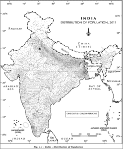
● India has a highly uneven pattern of population distribution. This can be seen in the picture given below:
● From the above figure, we can conclude that the North Indian plain in India has high population density as compared to other regions of the country.
Reasons:
● Such an uneven spatial distribution of population in India suggests a close relationship between population and physical, socioeconomic and historical factors.
Physical factors:
● Fertile alluvium soil: The plains are characterized by rich alluvial soil deposited by the Ganges, Yamuna, and Brahmaputra rivers. This soil is highly fertile and supports intensive agriculture, enabling high crop yields and the sustenance of large populations.
● Abundant water resources: The region is crisscrossed by numerous rivers and their tributaries, providing ample water for irrigation, drinking, and other uses. The extensive river network ensures reliable water supply, which is crucial for agriculture and daily life.
● Favourable climate: The North Indian Plain experiences a climate that supports multiple cropping seasons. The combination of sufficient rainfall during the monsoon and mild winters makes it possible to grow a variety of crops throughout the year.
Socio-economic factors:
● Agriculture and industry: The fertile land supports extensive agricultural activities, which remain a primary livelihood for many. Additionally, the region has seen significant industrial development, offering diverse employment opportunities.
⮚ Cities like Kanpur (leather), Panipat (textiles), and Ludhiana (textile) etc. have some very well-developed agro-industry set-up.
● Transportation and connectivity: The plains have well-developed infrastructure, including roads, railways, and airports, which enhance connectivity and economic activities. Good transportation networks facilitate trade and movement, contributing to higher population densities.
● Urbanization: Major cities such as Delhi, Kolkata, and Lucknow have developed into economic hubs, drawing people for jobs, education, and better living standards.
Historical factors:
● Civilisation centres: This region has been the cradle of major ancient civilizations, such as the Indus Valley Civilization, and has a long history of continuous human settlement. Historical factors have led to the establishment of large, prosperous cities and dense populations over millennia.
⮚ Example – The ancient cities of Mathura, Kashi, Ayodhya etc. are present here.Incorrect
Answer: B
Explanation
Fertile alluvium soil, High density of roads and railways and High availability of water are the three correct reasons as mentioned in the options
Density of roads and railways
Spatial distribution of population of India:
● India has a highly uneven pattern of population distribution. This can be seen in the picture given below:
● From the above figure, we can conclude that the North Indian plain in India has high population density as compared to other regions of the country.

Reasons:
● Such an uneven spatial distribution of population in India suggests a close relationship between population and physical, socioeconomic and historical factors.
Physical factors:
● Fertile alluvium soil: The plains are characterized by rich alluvial soil deposited by the Ganges, Yamuna, and Brahmaputra rivers. This soil is highly fertile and supports intensive agriculture, enabling high crop yields and the sustenance of large populations.
● Abundant water resources: The region is crisscrossed by numerous rivers and their tributaries, providing ample water for irrigation, drinking, and other uses. The extensive river network ensures reliable water supply, which is crucial for agriculture and daily life.
● Favourable climate: The North Indian Plain experiences a climate that supports multiple cropping seasons. The combination of sufficient rainfall during the monsoon and mild winters makes it possible to grow a variety of crops throughout the year.
Socio-economic factors:
● Agriculture and industry: The fertile land supports extensive agricultural activities, which remain a primary livelihood for many. Additionally, the region has seen significant industrial development, offering diverse employment opportunities.
⮚ Cities like Kanpur (leather), Panipat (textiles), and Ludhiana (textile) etc. have some very well-developed agro-industry set-up.
● Transportation and connectivity: The plains have well-developed infrastructure, including roads, railways, and airports, which enhance connectivity and economic activities. Good transportation networks facilitate trade and movement, contributing to higher population densities.
● Urbanization: Major cities such as Delhi, Kolkata, and Lucknow have developed into economic hubs, drawing people for jobs, education, and better living standards.
Historical factors:
● Civilisation centres: This region has been the cradle of major ancient civilizations, such as the Indus Valley Civilization, and has a long history of continuous human settlement. Historical factors have led to the establishment of large, prosperous cities and dense populations over millennia.
⮚ Example – The ancient cities of Mathura, Kashi, Ayodhya etc. are present here. -
Question 2 of 5
2. Question
2. Consider the following pairs:
Topographies – Agents of erosion
1. Basket of eggs topography – Wind
2. Karst topography – Groundwater
3. Badland topography – Glaciers
How many of the above pairs are correctly matched?Correct
Answer: A
Only Pair 2 is matched correctly
Topography – Agents of erosion
Basket of eggs topography – Glaciers
Karst topography – Groundwater
Badland topography – Rivers
Pair 1 is matched incorrectly:
Basket of eggs topography:
● Also known as “egg basket topography”.
● It is a term used to describe a landscape that features numerous small, rounded hills which collectively resemble a basket of eggs.
● This distinctive topography can be formed through various geological processes, particularly in glaciated regions.
Characteristics of “Basket of Eggs topography”:
● Numerous rounded hills: The landscape is characterized by many small, smooth, rounded hills or mounds.
● Uniform size and shape: These hills are typically of similar size and shape, contributing to a uniform appearance.
● Gentle slopes: The hills have gentle, convex slopes, giving them a smooth, rounded appearance.
● Even distribution: The hills are evenly distributed across the landscape, which contributes to the “basket of eggs” resemblance.

Formation processes:
The basket of eggs topography is primarily associated with glacial activity, particularly the formation of drumlins:
● Drumlins: Drumlins are streamlined, elongated hills composed of glacial till (unsorted sediment) that are formed beneath a moving glacier.
⮚ They often appear in clusters or fields, creating a landscape that looks like a basket of eggs. Drumlins are oriented parallel to the direction of glacial movement.
⮚ Example – In North America, significant drumlin fields can be found in parts of the United States (such as upstate New York) and Canada (especially in Ontario and the Prairie provinces).


Pair 2 is matched correctly:
About Karst topography:
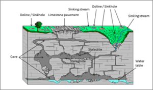
● Any limestone or dolomitic region showing typical landforms produced by the action of groundwater through the processes of solution and deposition is called Karst topography after the typical topography developed in limestone rocks of Karst region in the Balkans adjacent to Adriatic Sea.
Mechanism:
● The surface water percolates well when the rocks are permeable, thinly bedded and highly jointed and cracked.
● After vertically going down to some depth, the water under the ground flows horizontally through the bedding planes, joints or through the materials themselves.
● It is this downward and horizontal movement of water which causes the rocks to erode.
● Physical or mechanical removal of materials by moving groundwater is insignificant in developing landforms.
● That is why, the results of the work of groundwater cannot be seen in all types of rocks.
● But in rocks like limestones or dolomites rich in calcium carbonate, the surface water as well as groundwater through the chemical process of solution and precipitation deposition develop varieties of landforms.
● These two processes of solution and precipitation are active in limestones or dolomites occurring either exclusively or interbedded with other rocks.
Pair 3 is matched incorrectly:
Badland topography:
● Badland topography means a region that is adversely affected by soil erosion, and the formation of deep gullies and ravines is common.
● In arid regions, occasional rainstorms produce numerous rills and channels which extensively erode weak sedimentary formations.
● Ravines and gullies are developed by linear fluvial erosion leading to the formation of badland topography.
● Generally, in this area, agriculture is quite a difficult task to do.


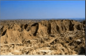
⮚ Example – In India, badland topography is found in the Chambal Basin.Incorrect
Answer: A
Only Pair 2 is matched correctly
Topography – Agents of erosion
Basket of eggs topography – Glaciers
Karst topography – Groundwater
Badland topography – Rivers
Pair 1 is matched incorrectly:
Basket of eggs topography:
● Also known as “egg basket topography”.
● It is a term used to describe a landscape that features numerous small, rounded hills which collectively resemble a basket of eggs.
● This distinctive topography can be formed through various geological processes, particularly in glaciated regions.
Characteristics of “Basket of Eggs topography”:
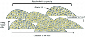
● Numerous rounded hills: The landscape is characterized by many small, smooth, rounded hills or mounds.
● Uniform size and shape: These hills are typically of similar size and shape, contributing to a uniform appearance.
● Gentle slopes: The hills have gentle, convex slopes, giving them a smooth, rounded appearance.
● Even distribution: The hills are evenly distributed across the landscape, which contributes to the “basket of eggs” resemblance.


Formation processes:
The basket of eggs topography is primarily associated with glacial activity, particularly the formation of drumlins:
● Drumlins: Drumlins are streamlined, elongated hills composed of glacial till (unsorted sediment) that are formed beneath a moving glacier.
⮚ They often appear in clusters or fields, creating a landscape that looks like a basket of eggs. Drumlins are oriented parallel to the direction of glacial movement.
⮚ Example – In North America, significant drumlin fields can be found in parts of the United States (such as upstate New York) and Canada (especially in Ontario and the Prairie provinces).


Pair 2 is matched correctly:
About Karst topography:
● Any limestone or dolomitic region showing typical landforms produced by the action of groundwater through the processes of solution and deposition is called Karst topography after the typical topography developed in limestone rocks of Karst region in the Balkans adjacent to Adriatic Sea.
Mechanism:
● The surface water percolates well when the rocks are permeable, thinly bedded and highly jointed and cracked.
● After vertically going down to some depth, the water under the ground flows horizontally through the bedding planes, joints or through the materials themselves.
● It is this downward and horizontal movement of water which causes the rocks to erode.
● Physical or mechanical removal of materials by moving groundwater is insignificant in developing landforms.
● That is why, the results of the work of groundwater cannot be seen in all types of rocks.
● But in rocks like limestones or dolomites rich in calcium carbonate, the surface water as well as groundwater through the chemical process of solution and precipitation deposition develop varieties of landforms.
● These two processes of solution and precipitation are active in limestones or dolomites occurring either exclusively or interbedded with other rocks.
Pair 3 is matched incorrectly:
Badland topography:
● Badland topography means a region that is adversely affected by soil erosion, and the formation of deep gullies and ravines is common.
● In arid regions, occasional rainstorms produce numerous rills and channels which extensively erode weak sedimentary formations.
● Ravines and gullies are developed by linear fluvial erosion leading to the formation of badland topography.
● Generally, in this area, agriculture is quite a difficult task to do.


⮚ Example – In India, badland topography is found in the Chambal Basin. -
Question 3 of 5
3. Question
3. In the context of heat budget of the earth, consider the following statements:
1. Out of the total incoming short-wave radiation, clouds reflect more radiation to space as compared to those getting scattered by particles in the atmosphere.
2. The atmosphere absorbs more units of short-wave radiation as compared to long-wave radiation.
3. Out of the total long-wave radiation emitted by the earth, more heat is lost to the atmosphere as latent heat of condensation than absorption by greenhouse gases.
How many of the given statements are correct?Correct
Answer: B
Explanation
Only Statement 2 is incorrect
Heat Budget of the Planet Earth:
● The earth as a whole does not accumulate or loose heat. It maintains its temperature. This can happen only if the amount of heat received in the form of insolation equals the amount lost by the earth through terrestrial radiation.
Account of incoming radiations/ insolation:
● Consider that the insolation received at the top of the atmosphere is 100 per cent.
● While passing through the atmosphere some amount of energy is reflected, scattered and absorbed. Only the remaining part reaches the earth surface.
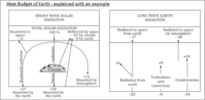
● Roughly 35 units are reflected back to space even before reaching the earth’s surface.
⮚ Of these, 27 units are reflected back from the top of the clouds and 2 units from the snow and ice-covered areas of the earth. The reflected amount of radiation is called the albedo of the earth.
⮚ On the other hand, 23 units (6 units directly scattered to space and 17 units scattered are absorbed by the earth, as shown in figure given below) are scattered by the particles in the atmosphere.
⮚ Hence, Statement 1 is incorrect.
● The remaining 65 units are absorbed.
⮚ 14 units within the atmosphere and 51 units by the earth’s surface.


Account of terrestrial radiations:
● The earth radiates back 51 units in the form of terrestrial radiation.
⮚ Of these, 17 units are radiated to space directly and the remaining 34 units are absorbed by the atmosphere.
✔ 6 units absorbed directly by the atmosphere
✔ 9 units through convection and turbulence
✔ 19 units through latent heat of condensation (Hence, Statement 3 is correct)
✔ Hence, Statement 3 is correct.
● 48 units absorbed by the atmosphere (14 units from insolation + 34 units from terrestrial radiation) are also radiated back into space.
⮚ Hence, Statement 2 is incorrect.
● Thus, the total radiation returning from the earth and the atmosphere respectively is 17+48=65 units which balance the total of 65 units received from the sun.
● This is termed the heat budget or heat balance of the earth.
● This explains why the earth neither warms up nor cools down despite the huge transfer of heat that takes place.Incorrect
Answer: B
Explanation
Only Statement 2 is incorrect
Heat Budget of the Planet Earth:
● The earth as a whole does not accumulate or loose heat. It maintains its temperature. This can happen only if the amount of heat received in the form of insolation equals the amount lost by the earth through terrestrial radiation.
Account of incoming radiations/ insolation:
● Consider that the insolation received at the top of the atmosphere is 100 per cent.
● While passing through the atmosphere some amount of energy is reflected, scattered and absorbed. Only the remaining part reaches the earth surface.
● Roughly 35 units are reflected back to space even before reaching the earth’s surface.
⮚ Of these, 27 units are reflected back from the top of the clouds and 2 units from the snow and ice-covered areas of the earth. The reflected amount of radiation is called the albedo of the earth.
⮚ On the other hand, 23 units (6 units directly scattered to space and 17 units scattered are absorbed by the earth, as shown in figure given below) are scattered by the particles in the atmosphere.
⮚ Hence, Statement 1 is incorrect.
● The remaining 65 units are absorbed.
⮚ 14 units within the atmosphere and 51 units by the earth’s surface.


Account of terrestrial radiations:
● The earth radiates back 51 units in the form of terrestrial radiation.
⮚ Of these, 17 units are radiated to space directly and the remaining 34 units are absorbed by the atmosphere.
✔ 6 units absorbed directly by the atmosphere
✔ 9 units through convection and turbulence
✔ 19 units through latent heat of condensation (Hence, Statement 3 is correct)
✔ Hence, Statement 3 is correct.
● 48 units absorbed by the atmosphere (14 units from insolation + 34 units from terrestrial radiation) are also radiated back into space.
⮚ Hence, Statement 2 is incorrect.
● Thus, the total radiation returning from the earth and the atmosphere respectively is 17+48=65 units which balance the total of 65 units received from the sun.
● This is termed the heat budget or heat balance of the earth.
● This explains why the earth neither warms up nor cools down despite the huge transfer of heat that takes place. -
Question 4 of 5
4. Question
4. The rate of decrease in temperature with increase in altitude is called lapse rate. Consider the following statements about the lapse rate:
1. It is usually more in winter than in summer.
2. It is greater at night than during the day.
3. It is greater on elevated highlands than on level plains.
How many of the above statements are correct?Correct
Answer: A
Explanation:
Only Statement 3 is correct
Normal Lapse Rate:
● Normally, temperature decreases with increase in elevation/altitude. It is called normal lapse rate (or simply lapse rate).
● This lapse rate is never constant, varying from place to place and from season to season.
● For all the practical reasons, the fall in temperature will be 6.5 degrees Celsius for every 1000 m rise in altitude.
Statement 1 is incorrect:
● It is usually more in summers than winters.
Reason: Lapse rate is more pronounced in summers than in winters because-
● There develops a greater temperature gradient in summer between the surface and the higher altitudes due to intense heating of earth surface. This gradient increases the lapse rate as the warm air try to rise further in summer season.
● Also, due to the intense surface heating causes strong convection currents. Warm air near the ground rises rapidly and cools as it ascends, which increases the lapse rate.
● In contrast, winter is characterized by more stable atmospheric conditions. The surface receives less solar heating, leading to a shallower temperature gradient and a lower lapse rate.
⮚ Example – In temperate latitudes, in summer season, an ascent of only 280 feet will cause the temperature to drop by 1 degree F whereas in winter, it requires 400 feet.
Statement 2 is incorrect:
● Lapse rate is greater during day time than at nights.
Reason:
● More intense heating of earth surface during daytime which makes the warm air rise (relatively more convection during daytime) and lapse rate becomes more prominent.
● While during the night, the earth’s surface loses heat through radiation. This cooling can lead to temperature inversions, where the air near the ground becomes cooler than the air above it. This inversion reduces or even reverses the lapse rate, resulting in a smaller or negative lapse rate.
Statement 3 is correct:
The lapse rate is greater on elevated highlands than on level plains.
Reason:
● Enhanced solar heating due to proximity to sun: Elevated highlands are closer to the sun compared to lower plains, resulting in more intense solar heating of the surface. This can lead to a steeper temperature gradient as the air heats up more rapidly and then cools quickly with altitude.
● Lower pressure at higher altitudes: At higher elevations, atmospheric pressure is lower. This reduced pressure leads to greater expansion and cooling of rising air, increasing the lapse rate.
⮚ On level plains, the higher atmospheric pressure results in less expansion and cooling of rising air.Incorrect
Answer: A
Explanation:
Only Statement 3 is correct
Normal Lapse Rate:
● Normally, temperature decreases with increase in elevation/altitude. It is called normal lapse rate (or simply lapse rate).
● This lapse rate is never constant, varying from place to place and from season to season.
● For all the practical reasons, the fall in temperature will be 6.5 degrees Celsius for every 1000 m rise in altitude.
Statement 1 is incorrect:
● It is usually more in summers than winters.
Reason: Lapse rate is more pronounced in summers than in winters because-
● There develops a greater temperature gradient in summer between the surface and the higher altitudes due to intense heating of earth surface. This gradient increases the lapse rate as the warm air try to rise further in summer season.
● Also, due to the intense surface heating causes strong convection currents. Warm air near the ground rises rapidly and cools as it ascends, which increases the lapse rate.
● In contrast, winter is characterized by more stable atmospheric conditions. The surface receives less solar heating, leading to a shallower temperature gradient and a lower lapse rate.
⮚ Example – In temperate latitudes, in summer season, an ascent of only 280 feet will cause the temperature to drop by 1 degree F whereas in winter, it requires 400 feet.
Statement 2 is incorrect:
● Lapse rate is greater during day time than at nights.
Reason:
● More intense heating of earth surface during daytime which makes the warm air rise (relatively more convection during daytime) and lapse rate becomes more prominent.
● While during the night, the earth’s surface loses heat through radiation. This cooling can lead to temperature inversions, where the air near the ground becomes cooler than the air above it. This inversion reduces or even reverses the lapse rate, resulting in a smaller or negative lapse rate.
Statement 3 is correct:
The lapse rate is greater on elevated highlands than on level plains.
Reason:
● Enhanced solar heating due to proximity to sun: Elevated highlands are closer to the sun compared to lower plains, resulting in more intense solar heating of the surface. This can lead to a steeper temperature gradient as the air heats up more rapidly and then cools quickly with altitude.
● Lower pressure at higher altitudes: At higher elevations, atmospheric pressure is lower. This reduced pressure leads to greater expansion and cooling of rising air, increasing the lapse rate.
⮚ On level plains, the higher atmospheric pressure results in less expansion and cooling of rising air. -
Question 5 of 5
5. Question
5. Consider the following pairs:
National geological monuments – States
1. Erra Matti Dibbalu – Tamil Nadu
2. Columnar Lava at St. Mary Island – Karnataka
3. Siwalik Fossil Park – Uttarakhand
How many of the above pairs are correctly matched?Correct
Answer: A
Explanation:
Only Pair 2 is matched correctly
National geological monuments – States
Erra Matti Dibbalu – Andhra Pradesh
Columnar Lava at St. Mary Island – Karnataka
Siwalik Fossil Park – Himachal Pradesh
Pair 1 is matched incorrectly:
About Erra Matti Dibbalu:
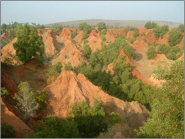
● Erra Matti Dibbalu meaning ‘Red Mud Hillocks’ in Telugu is situated at the outskirts of Visakhapatnam city, Andhra Pradesh.
● It is located very near to the Bay of Bengal and is one of Visakhapatnam’s many heritage sites.
● It is a notified National Geo-heritage Monument.
⮚ It was recognised as a national geo-heritage site in 2014 and as a protected site by the Andhra Pradesh Government in 2016.
⮚ The Geological Survey of India (GSI) declares geo-heritage sites/ national geological monuments for protection and maintenance.
● Popularly known as the Red Soil Hills, these natural ravines spread extensively in various formations some jagged, some deep, some maze-like and some creating walls along trekking pathways due to recurring wind currents and soil erosion.
● It is said to be over a million years old, they comprise sand, clay and silt and are acknowledged as a rare geographic phenomenon.
● Erra Matti Dibbalu holds a lot of significance geologically, as they are helpful for geologists to study global climatic changes, sea-level variations and monsoonal variability.
● Today, the site is facing threats of disintegration due to rapid realtyc sector growth in the city.


Pair 2 is matched correctly:
About Columnar Lava at St Mary Island:
● St. Mary’s Islands, also known as Coconut Island and Thonsepar, are a set of four small islands in the Arabian Sea off the coast of Malpe in Udipi, Karnataka, India.
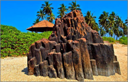
● They are known for their distinctive geological formation of columnar rhyolitic lava.
⮚ The columnar basaltic lava found in these Islands, which is very well developed in the basalts of Deccan Traps, exhibit an imposing range of hexagonal shaped or multi-faced (polygonal) columns split into a horizontal mosaic.
⮚ In geological terms these are called “columnar joints”. The lava rocks form regular five, six or seven-sided pillars, called “laminar lava”, and are found in varying heights in all the islands; the tallest of the columns is about 6 m (20 ft).
● Columnar rhyolite lava here form one of the four geological monuments in Karnataka state, declared by the Geological Survey of India for their protection, maintenance, promotion and enhancement of geotourism.
● The monument is considered an important site for “Geo Tourism”.


Pair 3 is matched incorrectly:
About Shivalik Fossil Park:
● Located in: Saketi, Sirmaur District of Himachal Pradesh.
● Shivalik Fossil Park is one of its kinds in Asia.
● Inaugurated in 1974, the park is spread over an area of 1.5 sq km area and claimed to be one of the largest fossil parks in Asia.
● Declared a Geological Heritage Site by ASI in 2022.
● Importance: The Siwalik Fossil Park displays a rich collection of vertebrate fossils recovered from the Siwalik rocks of the area of Plio-Pleistocene age.
⮚ The deposition of Siwalik sediments took place in the narrow linear depression, called the ‘fore deep’, which started developing in front of the Himalayas since the inception of its uplift in the middle Miocene.


 Incorrect
Answer: A
Explanation:
Only Pair 2 is matched correctly
National geological monuments – States
Erra Matti Dibbalu – Andhra Pradesh
Columnar Lava at St. Mary Island – Karnataka
Siwalik Fossil Park – Himachal Pradesh
Pair 1 is matched incorrectly:
About Erra Matti Dibbalu:
● Erra Matti Dibbalu meaning ‘Red Mud Hillocks’ in Telugu is situated at the outskirts of Visakhapatnam city, Andhra Pradesh.
● It is located very near to the Bay of Bengal and is one of Visakhapatnam’s many heritage sites.
● It is a notified National Geo-heritage Monument.
⮚ It was recognised as a national geo-heritage site in 2014 and as a protected site by the Andhra Pradesh Government in 2016.
⮚ The Geological Survey of India (GSI) declares geo-heritage sites/ national geological monuments for protection and maintenance.
● Popularly known as the Red Soil Hills, these natural ravines spread extensively in various formations some jagged, some deep, some maze-like and some creating walls along trekking pathways due to recurring wind currents and soil erosion.
● It is said to be over a million years old, they comprise sand, clay and silt and are acknowledged as a rare geographic phenomenon.
● Erra Matti Dibbalu holds a lot of significance geologically, as they are helpful for geologists to study global climatic changes, sea-level variations and monsoonal variability.
● Today, the site is facing threats of disintegration due to rapid realtyc sector growth in the city.


Pair 2 is matched correctly:
About Columnar Lava at St Mary Island:
● St. Mary’s Islands, also known as Coconut Island and Thonsepar, are a set of four small islands in the Arabian Sea off the coast of Malpe in Udipi, Karnataka, India.
● They are known for their distinctive geological formation of columnar rhyolitic lava.
⮚ The columnar basaltic lava found in these Islands, which is very well developed in the basalts of Deccan Traps, exhibit an imposing range of hexagonal shaped or multi-faced (polygonal) columns split into a horizontal mosaic.
⮚ In geological terms these are called “columnar joints”. The lava rocks form regular five, six or seven-sided pillars, called “laminar lava”, and are found in varying heights in all the islands; the tallest of the columns is about 6 m (20 ft).
● Columnar rhyolite lava here form one of the four geological monuments in Karnataka state, declared by the Geological Survey of India for their protection, maintenance, promotion and enhancement of geotourism.
● The monument is considered an important site for “Geo Tourism”.


Pair 3 is matched incorrectly:
About Shivalik Fossil Park:
● Located in: Saketi, Sirmaur District of Himachal Pradesh.
● Shivalik Fossil Park is one of its kinds in Asia.
● Inaugurated in 1974, the park is spread over an area of 1.5 sq km area and claimed to be one of the largest fossil parks in Asia.
● Declared a Geological Heritage Site by ASI in 2022.
● Importance: The Siwalik Fossil Park displays a rich collection of vertebrate fossils recovered from the Siwalik rocks of the area of Plio-Pleistocene age.
⮚ The deposition of Siwalik sediments took place in the narrow linear depression, called the ‘fore deep’, which started developing in front of the Himalayas since the inception of its uplift in the middle Miocene.


