Day-720
Quiz-summary
0 of 5 questions completed
Questions:
- 1
- 2
- 3
- 4
- 5
Information
DAILY MCQ
You have already completed the quiz before. Hence you can not start it again.
Quiz is loading...
You must sign in or sign up to start the quiz.
You have to finish following quiz, to start this quiz:
Results
0 of 5 questions answered correctly
Your time:
Time has elapsed
You have reached 0 of 0 points, (0)
Categories
- Not categorized 0%
- 1
- 2
- 3
- 4
- 5
- Answered
- Review
-
Question 1 of 5
1. Question
1. Consider the following statements:
1. Krem Liat Prah cave of Meghalaya is the longest natural cave in India.
2. Borra cave of Andhra Pradesh is an example of Karst topography.
3. Mawmluh cave of Nagaland has been listed as UNESCO’s one of the ‘First 100 IUGS (International Union of Geological Sciences) Geological Sites’ in the world.
Which of the statements given above is/are correct?Correct
Answer: B
Explanation:
Statement 3 is incorrect: Mawmluh cave is located in Meghalaya.
Statement 1 is correct:
About Krem Liat Prah Caves:
● Krem is the Khasi word for “cave”.
● Krem Liat Prah is the longest natural cave in South Asia.
● Also known as the Cave of the Tiger, it is one of the longest limestone caves in the world.
● Prah is one of approximately 150 known caves in the Shnongrim Ridge of the East Jaintia Hills district in the state of Meghalaya, northeast India.

Statement 2 is correct:
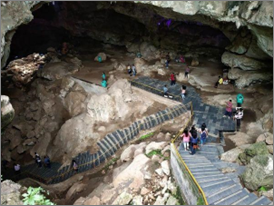
About Borra Caves:
● Location: The Borra Caves or Borrā Guhalu are located on the east coast of India, in the Ananthagiri hills of the Araku Valley of the Alluri Sitharama Raju district in Andhra Pradesh.
● The native name for the caves is Borrā Guhalu where Borra means abdomen and Guhalu means caves in Telugu language.
● The caves, one of the largest in the country, at an elevation of about 705 m, distinctly exhibit a variety of speleothems ranging in size and irregularly shaped stalactites and stalagmites representing the karst topography.
● The caves are basically karstic limestone structures extending to a depth of 80 m and are considered the deepest caves in India.
Statement 3 is incorrect:
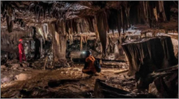
About Mawmluh Cave:
● Location: located near Mawmluh, a small hamlet in Meghalaya.
● It is believed to be the fourth longest cave in the Indian subcontinent with a total length of 7 km of cave passages.
● Features: The cave is too deep and contains passages, calcite formations of various kinds, massive caverns, waist-deep pools, a few meters of belly crawl, and few climbs.
⮚ Only one-fourth of the cave receives sunlight while the rest of the cave remains shrouded in the darkness.
● Mawmluh Cave in Meghalaya, locally known as Krem Mawmluh, has been listed as UNESCO’s one of the ‘First 100 IUGS (International Union of Geological Sciences) Geological Sites’ in the world.
● It is also believed that the stalagmite from this cave helped prove the existence of a 200-year-long drought that occurred after the Ice Age around 4,200 ago, destroying many civilisations around the world. To describe this period, the term ‘Meghalayan Age’ was coined.


 Incorrect
Answer: B
Explanation:
Statement 3 is incorrect: Mawmluh cave is located in Meghalaya.
Statement 1 is correct:
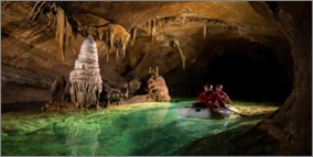
About Krem Liat Prah Caves:
● Krem is the Khasi word for “cave”.
● Krem Liat Prah is the longest natural cave in South Asia.
● Also known as the Cave of the Tiger, it is one of the longest limestone caves in the world.
● Prah is one of approximately 150 known caves in the Shnongrim Ridge of the East Jaintia Hills district in the state of Meghalaya, northeast India.


Statement 2 is correct:
About Borra Caves:
● Location: The Borra Caves or Borrā Guhalu are located on the east coast of India, in the Ananthagiri hills of the Araku Valley of the Alluri Sitharama Raju district in Andhra Pradesh.
● The native name for the caves is Borrā Guhalu where Borra means abdomen and Guhalu means caves in Telugu language.
● The caves, one of the largest in the country, at an elevation of about 705 m, distinctly exhibit a variety of speleothems ranging in size and irregularly shaped stalactites and stalagmites representing the karst topography.
● The caves are basically karstic limestone structures extending to a depth of 80 m and are considered the deepest caves in India.

Statement 3 is incorrect:
About Mawmluh Cave:
● Location: located near Mawmluh, a small hamlet in Meghalaya.
● It is believed to be the fourth longest cave in the Indian subcontinent with a total length of 7 km of cave passages.
● Features: The cave is too deep and contains passages, calcite formations of various kinds, massive caverns, waist-deep pools, a few meters of belly crawl, and few climbs.
⮚ Only one-fourth of the cave receives sunlight while the rest of the cave remains shrouded in the darkness.
● Mawmluh Cave in Meghalaya, locally known as Krem Mawmluh, has been listed as UNESCO’s one of the ‘First 100 IUGS (International Union of Geological Sciences) Geological Sites’ in the world.
● It is also believed that the stalagmite from this cave helped prove the existence of a 200-year-long drought that occurred after the Ice Age around 4,200 ago, destroying many civilisations around the world. To describe this period, the term ‘Meghalayan Age’ was coined.


-
Question 2 of 5
2. Question
2. Consider the following pairs:
Waterfalls – Rivers
1. Chitrakote falls – Mahanadi river
2. Hundru falls – Damodar river
3. Hogenakkal falls – Cauvery river
4. Duduma falls – Machkund river
How many of the above pairs are correctly matched?Correct
Answer: B
Explanation:
Waterfalls – Rivers
1. Chitrakote falls – Indravati river
2. Hundru falls – Subarnarekha river
3. Hogenakkal falls – Cauvery river
4. Duduma falls – Machkund river
Pair 1 is matched incorrectly:
Chitrakote Falls:
● The Chitrakote falls is a natural waterfall on the Indravati River.
● Location: Located approximately 38 kilometres to the west of Jagdalpur, in Bastar district in Chhattisgarh.
● Height: About 29 metres (95 ft)
● It is the widest waterfall in India, reaching a width of nearly 300 metres (980 ft) during the monsoon season.


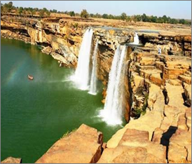
⮚ Because of its width and its widespread horseshoe shape during the monsoon season, it is often called the “Niagara Falls of India”.
⮚ The specialty of this waterfall is that during the rainy days, this water is reddish; it looks absolutely white during the summer moonlight night.
Pair 2 is matched incorrectly:
About Hundru Falls:
● Location: Situated at a distance of 45 kilometers from the main city of Ranchi in Jharkhand.
● The Hundru falls is created on the course of the Subarnarekha River, where it falls from a height of 320 feet creating the highest waterfalls of the state.
● It is one of the several scarp falls in the region.
● It is an example of a Knick point caused by rejuvenation.
⮚ A knickpoint, also called a nick point or simply nick, represents breaks in slopes in the longitudinal profile of a river caused by rejuvenation.
⮚ The break in channel gradient allows water to fall vertically giving rise to a waterfall.
Pair 3 is matched correctly:
About Hogenakkal Falls:
● Hogenakkal falls is a waterfall in South India on the Kaveri river on the border between Dharmapuri district of Tamil Nadu and Chamarajanagar district of Karnataka.
● In Hogenakkal, the river Cauvery enters into Tamil Nadu as a big river with gushing water presentable as a natural falls.
● The name Hogenakkal is derived from Kannada meaning ‘Smoky Rocks’.


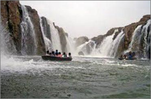
⮚ When the river falls on the rock below, the gushing force of water resembles smoke emanating from the rocks.
Pair 4 is matched correctly:
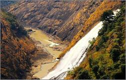
About Duduma Waterfall:
● Location: Situated in the border of Koraput district of Odisha.
● This horsetail type waterfall is 175 metres (574 ft) in height and is formed by the Machkund river.
● Duduma has two sub waterfalls, one drops down in Andhra Pradesh and the other in Odisha.


 Incorrect
Answer: B
Explanation:
Waterfalls – Rivers
1. Chitrakote falls – Indravati river
2. Hundru falls – Subarnarekha river
3. Hogenakkal falls – Cauvery river
4. Duduma falls – Machkund river
Pair 1 is matched incorrectly:
Chitrakote Falls:
● The Chitrakote falls is a natural waterfall on the Indravati River.
● Location: Located approximately 38 kilometres to the west of Jagdalpur, in Bastar district in Chhattisgarh.
● Height: About 29 metres (95 ft)
● It is the widest waterfall in India, reaching a width of nearly 300 metres (980 ft) during the monsoon season.


⮚ Because of its width and its widespread horseshoe shape during the monsoon season, it is often called the “Niagara Falls of India”.
⮚ The specialty of this waterfall is that during the rainy days, this water is reddish; it looks absolutely white during the summer moonlight night.
Pair 2 is matched incorrectly:
About Hundru Falls:
● Location: Situated at a distance of 45 kilometers from the main city of Ranchi in Jharkhand.
● The Hundru falls is created on the course of the Subarnarekha River, where it falls from a height of 320 feet creating the highest waterfalls of the state.
● It is one of the several scarp falls in the region.
● It is an example of a Knick point caused by rejuvenation.
⮚ A knickpoint, also called a nick point or simply nick, represents breaks in slopes in the longitudinal profile of a river caused by rejuvenation.
⮚ The break in channel gradient allows water to fall vertically giving rise to a waterfall.
Pair 3 is matched correctly:
About Hogenakkal Falls:
● Hogenakkal falls is a waterfall in South India on the Kaveri river on the border between Dharmapuri district of Tamil Nadu and Chamarajanagar district of Karnataka.
● In Hogenakkal, the river Cauvery enters into Tamil Nadu as a big river with gushing water presentable as a natural falls.
● The name Hogenakkal is derived from Kannada meaning ‘Smoky Rocks’.


⮚ When the river falls on the rock below, the gushing force of water resembles smoke emanating from the rocks.
Pair 4 is matched correctly:
About Duduma Waterfall:
● Location: Situated in the border of Koraput district of Odisha.
● This horsetail type waterfall is 175 metres (574 ft) in height and is formed by the Machkund river.
● Duduma has two sub waterfalls, one drops down in Andhra Pradesh and the other in Odisha.


-
Question 3 of 5
3. Question
3. Consider the following statements about rapeseed and mustard:
1. While rapeseed is a kharif crop, mustard is a rabi crop.
2. Rapeseed contains about 42% oil and mustard contains about 38-40% oil.
3. Rapeseed oil is used in the manufacturing of greases.
4. Mustard oil is used in the tanning industry for softening the leather.
How many of the above statements are correct?Correct
Answer: C
Explanation:
Only Statement 1 is incorrect
Statement 1 is incorrect:
Rapeseed and Mustard:
● Rapeseed and mustard comprise several oilseeds such as rai, sarson, toria and taramira.
● These are subtropical crops cultivated during rabi season in north-western and central parts of India.
● These are frost sensitive crops and their yields fluctuate from year to year.
● These oilseeds together occupy only 2.5 per cent of total cropped area in the country.
● Rajasthan contributes about one-third production while other leading producers are Uttar Pradesh, Haryana, West Bengal and Madhya Pradesh.
● Yields of these crops are comparatively high in Haryana and Rajasthan.
Statement 2 is correct:
● The oil content of the rapeseed and mustard ranges from 25 to 45 percent.
● Rapeseed contains about 42 % oil and mustard contains about 38-40 % oil.
Statement 3 is correct:
Uses of rape seed oil:
● Rapeseed oil is used as a cooking medium, preservatives for pickles, toiletries, lubricants and greases.
● Oil cakes form an important cattle feed and are also used as manure.
Statement 4 is correct:
Uses of mustard oil:
● Mustard essential oil has great anti-inflammatory properties. Historically, mustard oil has been used to:
⮚ As cooking oil (Mustard oil contains erucic acid in high amount and it is removed before use as edible oil)
⮚ Treat arthritis
⮚ Soothe aches and pains
⮚ Decrease inflammation from chest conditions such as bronchitis and pneumonia
⮚ Relieves Body pain
● In the tanning industry, mustard oil is used for softening leather.Incorrect
Answer: C
Explanation:
Only Statement 1 is incorrect
Statement 1 is incorrect:
Rapeseed and Mustard:
● Rapeseed and mustard comprise several oilseeds such as rai, sarson, toria and taramira.
● These are subtropical crops cultivated during rabi season in north-western and central parts of India.
● These are frost sensitive crops and their yields fluctuate from year to year.
● These oilseeds together occupy only 2.5 per cent of total cropped area in the country.
● Rajasthan contributes about one-third production while other leading producers are Uttar Pradesh, Haryana, West Bengal and Madhya Pradesh.
● Yields of these crops are comparatively high in Haryana and Rajasthan.
Statement 2 is correct:
● The oil content of the rapeseed and mustard ranges from 25 to 45 percent.
● Rapeseed contains about 42 % oil and mustard contains about 38-40 % oil.
Statement 3 is correct:
Uses of rape seed oil:
● Rapeseed oil is used as a cooking medium, preservatives for pickles, toiletries, lubricants and greases.
● Oil cakes form an important cattle feed and are also used as manure.
Statement 4 is correct:
Uses of mustard oil:
● Mustard essential oil has great anti-inflammatory properties. Historically, mustard oil has been used to:
⮚ As cooking oil (Mustard oil contains erucic acid in high amount and it is removed before use as edible oil)
⮚ Treat arthritis
⮚ Soothe aches and pains
⮚ Decrease inflammation from chest conditions such as bronchitis and pneumonia
⮚ Relieves Body pain
● In the tanning industry, mustard oil is used for softening leather. -
Question 4 of 5
4. Question
4. Which of the following is not a lagoon lake?
Correct
Answer: D
Explanation:
Kolleru lake is not a lagoon lake
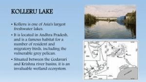
About Kolleru lake:
● Kolleru Lake is one of the largest freshwater lakes in India and is located in Andhra Pradesh.
● Kolleru is located between Krishna and Godavari delta and covers an area of 308 sq. km.
● The lake serves as a natural flood-balancing reservoir for these two rivers.
● The lake is fed directly by water from the seasonal Budameru and Tammileru streams, and is connected to the Krishna and Godavari systems by over 68 inflowing drains and channels.
● It serves as a habitat for migratory birds.
● It supports the livelihood of fishermen and riparian population in the area.
● The lake was notified as a wildlife sanctuary in November 1999 under India’s Wildlife (Protection) Act, 1972, and designated a wetland of international importance in November 2002 under the international Ramsar Convention.


Other lakes mentioned in the options are all lagoon lakes:
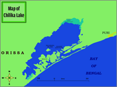
Chilika lake:
● Chilika Lake is the largest brackish water lagoon in Asia and second largest coastal lagoon in the world.
● It is spread over the Puri, Khordha and Ganjam districts of Odisha state on the east coast of India.
● Located at the mouth of the Daya River, flowing into the Bay of Bengal, covering an area of over 1,100 square kilometres.
● Its salinity varies by region, from freshwater where rivers flow in, to oceanic salinity levels due to tidal influx.


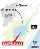
Kaliveli lake:
● Kaliveli Lake is a coastal lake and lagoon with wetlands in the Viluppuram District of Tamil Nadu state.
● This lake is on the Coromandel Coast, near the Bay of Bengal.
● It lies approximately 16 kilometres north of Pondicherry city, and 10 kilometres north of Auroville.


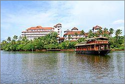
Ashtamudi lake:
● Located in the Kollam District of Kerala.
● Ashtamudi means ‘eight hills or peaks’ (Ashta : ‘eight’; mudi : ‘peaks’) in the local Malayalam language. The name is indicative of the lake’s topography with its multiple branches.
● It possesses a unique wetland ecosystem and a large palm-shaped water body.
● The lake is also called the gateway to the backwaters of Kerala and is well known for its houseboat and backwater resorts.
● Ashtamudi Wetland was included in the list of wetlands of international importance under Ramsar Convention.


 Incorrect
Answer: D
Explanation:
Kolleru lake is not a lagoon lake
About Kolleru lake:
● Kolleru Lake is one of the largest freshwater lakes in India and is located in Andhra Pradesh.
● Kolleru is located between Krishna and Godavari delta and covers an area of 308 sq. km.
● The lake serves as a natural flood-balancing reservoir for these two rivers.
● The lake is fed directly by water from the seasonal Budameru and Tammileru streams, and is connected to the Krishna and Godavari systems by over 68 inflowing drains and channels.
● It serves as a habitat for migratory birds.
● It supports the livelihood of fishermen and riparian population in the area.
● The lake was notified as a wildlife sanctuary in November 1999 under India’s Wildlife (Protection) Act, 1972, and designated a wetland of international importance in November 2002 under the international Ramsar Convention.


Other lakes mentioned in the options are all lagoon lakes:
Chilika lake:
● Chilika Lake is the largest brackish water lagoon in Asia and second largest coastal lagoon in the world.
● It is spread over the Puri, Khordha and Ganjam districts of Odisha state on the east coast of India.
● Located at the mouth of the Daya River, flowing into the Bay of Bengal, covering an area of over 1,100 square kilometres.
● Its salinity varies by region, from freshwater where rivers flow in, to oceanic salinity levels due to tidal influx.


Kaliveli lake:
● Kaliveli Lake is a coastal lake and lagoon with wetlands in the Viluppuram District of Tamil Nadu state.
● This lake is on the Coromandel Coast, near the Bay of Bengal.
● It lies approximately 16 kilometres north of Pondicherry city, and 10 kilometres north of Auroville.


Ashtamudi lake:
● Located in the Kollam District of Kerala.
● Ashtamudi means ‘eight hills or peaks’ (Ashta : ‘eight’; mudi : ‘peaks’) in the local Malayalam language. The name is indicative of the lake’s topography with its multiple branches.
● It possesses a unique wetland ecosystem and a large palm-shaped water body.
● The lake is also called the gateway to the backwaters of Kerala and is well known for its houseboat and backwater resorts.
● Ashtamudi Wetland was included in the list of wetlands of international importance under Ramsar Convention.


-
Question 5 of 5
5. Question
5. Which of the following is not a part of the Damodar Valley Corporation Multipurpose project?
Correct
Answer: A
Explanation:
Hatia dam is not a part of Damodar Valley Corporation Multipurpose project
About Damodar Valley Corporation Multipurpose project:
Damodar river:
● Damodar river is a tributary of the Hugli river.
● Flows in the west to east direction through Jharkhan and West Bengal.
● Total length = 541 km (270 km in Jharkhand and remaining 271 km in West Bengal).
● It became notorious for its floods and was known as the ‘River of Sorrow’.
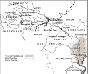
In order to control the floods and other related problems, the Damodar Valley Corporation Multipurpose project was conceived. It involves following dams constructed under it:
Tilaiya dam:
● Constructed on the Barak river.
● Construction started in 1950 and completed in 1953.
Konar dam:
● Constructed on Konar river in Hazaribagh district of Jharkhand.
● It is 3549 metres long and its maximum height above the river bed is 49 metres.
● It is an earthen dam with a concrete spillway.
● Bokaro steel plant and Bokaro thermal plant receive hydroelectric power and clean water respectively from this dam.
Maithon dam:
● Constructed on Barakar river, a little upstream from the confluence of rivers Damodar and Barakar.
● Maximum height of the dam is 49 metres.
Panchet Hill dam:
● An earthen dam with concrete spill-way which is constructed on river Damodar.
● Maximum height of 49 metres.
● Completed in 1959.
Durgapur barrage:
● Located at about 23 km from Raniganj has been created for the storage of irrigation water.
● Height is 12 metres.
● It stores water from Konar, Talaiya, Maithon and Panchet hill dams.


 Incorrect
Answer: A
Explanation:
Hatia dam is not a part of Damodar Valley Corporation Multipurpose project
About Damodar Valley Corporation Multipurpose project:
Damodar river:
● Damodar river is a tributary of the Hugli river.
● Flows in the west to east direction through Jharkhan and West Bengal.
● Total length = 541 km (270 km in Jharkhand and remaining 271 km in West Bengal).
● It became notorious for its floods and was known as the ‘River of Sorrow’.
In order to control the floods and other related problems, the Damodar Valley Corporation Multipurpose project was conceived. It involves following dams constructed under it:
Tilaiya dam:
● Constructed on the Barak river.
● Construction started in 1950 and completed in 1953.
Konar dam:
● Constructed on Konar river in Hazaribagh district of Jharkhand.
● It is 3549 metres long and its maximum height above the river bed is 49 metres.
● It is an earthen dam with a concrete spillway.
● Bokaro steel plant and Bokaro thermal plant receive hydroelectric power and clean water respectively from this dam.
Maithon dam:
● Constructed on Barakar river, a little upstream from the confluence of rivers Damodar and Barakar.
● Maximum height of the dam is 49 metres.
Panchet Hill dam:
● An earthen dam with concrete spill-way which is constructed on river Damodar.
● Maximum height of 49 metres.
● Completed in 1959.
Durgapur barrage:
● Located at about 23 km from Raniganj has been created for the storage of irrigation water.
● Height is 12 metres.
● It stores water from Konar, Talaiya, Maithon and Panchet hill dams.


