Day-686
Quiz-summary
0 of 5 questions completed
Questions:
- 1
- 2
- 3
- 4
- 5
Information
DAILY MCQ
You have already completed the quiz before. Hence you can not start it again.
Quiz is loading...
You must sign in or sign up to start the quiz.
You have to finish following quiz, to start this quiz:
Results
0 of 5 questions answered correctly
Your time:
Time has elapsed
You have reached 0 of 0 points, (0)
Categories
- Not categorized 0%
- 1
- 2
- 3
- 4
- 5
- Answered
- Review
-
Question 1 of 5
1. Question
1. Consider the following statements:
1. Eco-sensitive Zones (ESZ) are defined under the Wildlife Conservation Strategy, 2002.
2. The guidelines given by the Union Environment Ministry stipulate that the boundary of an ESZ should not exceed 10 kms around the protected areas in any case.
3. The ESZ has to be identified, declared and notified by the respective State government.
How many of the above statements are correct?Correct
Answer. A
Explanation:
Statement 1 is correct: The concept of Eco Sensitive Zone was conceived during the XXI meeting of the Indian Board for Wildlife held on 21st January, 2002, when the Wildlife Conservation Strategy, 2002 was adopted. The point no. 9 of the Wildlife Conservation Strategy, 2002 envisaged that “lands falling within 10kms of the boundaries of national parks and sanctuaries should be notified as eco-fragile zones under section 3(v) of the Environment (Protection) Act, 1986 and Rule 5, sub-rule (viii) and (x) of the environment (Protections) Rules”. The National Wildlife Action Plan (NWAP) (2002-2016) indicated that ‘Areas outside the protected area network are often vital ecological corridor links and must be protected to prevent isolation of fragments of biodiversity which will not survive in the long run. Land and water use policies will need to accept the imperative of strictly protecting ecologically fragile habitat and regulating use elsewhere’.
Statement 2 is incorrect: While the 10-km rule is implemented as a general principle, the extent of its application can vary. Areas beyond 10 km can also be notified by the Union government as ESZs, if they hold larger ecologically important “sensitive corridors”. The basic aim is to regulate certain activities around National Parks and Wildlife Sanctuaries so as to minimise the negative impacts of such activities on the fragile ecosystem encompassing the protected areas.
The extent of ESZs from the boundary of a protected area ranges from 0 to as much as 45.82 km (in Pin Valley National Park, Himachal Pradesh). Fifteen states have ESZs exceeding 10 km.
Statement 3 is incorrect: Survey and identification of ESZs are conducted by the respective State Governments for consideration of the Central Government for declaration of the ESZs in respective States around National Parks and Wildlife Sanctuaries as per the guidelines formulated by the Ministry of Environment, Forest and Climate Change (MoEF&CC). On the basis of proposals and recommendations of the State Government, the Ministry of Environment notifies the ESZs under the Environment (Protection) Act, 1986.Incorrect
Answer. A
Explanation:
Statement 1 is correct: The concept of Eco Sensitive Zone was conceived during the XXI meeting of the Indian Board for Wildlife held on 21st January, 2002, when the Wildlife Conservation Strategy, 2002 was adopted. The point no. 9 of the Wildlife Conservation Strategy, 2002 envisaged that “lands falling within 10kms of the boundaries of national parks and sanctuaries should be notified as eco-fragile zones under section 3(v) of the Environment (Protection) Act, 1986 and Rule 5, sub-rule (viii) and (x) of the environment (Protections) Rules”. The National Wildlife Action Plan (NWAP) (2002-2016) indicated that ‘Areas outside the protected area network are often vital ecological corridor links and must be protected to prevent isolation of fragments of biodiversity which will not survive in the long run. Land and water use policies will need to accept the imperative of strictly protecting ecologically fragile habitat and regulating use elsewhere’.
Statement 2 is incorrect: While the 10-km rule is implemented as a general principle, the extent of its application can vary. Areas beyond 10 km can also be notified by the Union government as ESZs, if they hold larger ecologically important “sensitive corridors”. The basic aim is to regulate certain activities around National Parks and Wildlife Sanctuaries so as to minimise the negative impacts of such activities on the fragile ecosystem encompassing the protected areas.
The extent of ESZs from the boundary of a protected area ranges from 0 to as much as 45.82 km (in Pin Valley National Park, Himachal Pradesh). Fifteen states have ESZs exceeding 10 km.
Statement 3 is incorrect: Survey and identification of ESZs are conducted by the respective State Governments for consideration of the Central Government for declaration of the ESZs in respective States around National Parks and Wildlife Sanctuaries as per the guidelines formulated by the Ministry of Environment, Forest and Climate Change (MoEF&CC). On the basis of proposals and recommendations of the State Government, the Ministry of Environment notifies the ESZs under the Environment (Protection) Act, 1986. -
Question 2 of 5
2. Question
2. Consider the following:
1. Prevalence of onshore winds
2. Persistent high atmospheric pressure
3. Rain-shadow effect
4. Warm ocean current flowing along the coast
How many of the above are possible reasons for the formation of desert?Correct
Answer: B
Explanation: Statements 2 and 3 are correct
About Arid or Desert Landforms:
● Deserts: Areas that receive less than 25 centimeters (10 inches) of rain annually are called deserts.
● True deserts: Deserts that are absolutely barren and where nothing grows at all are known as ‘true deserts’.
● About one fifth of the world’s land is made up of deserts.
Reasons for formation of deserts: Deserts are formed at different levels of latitudes i.e. tropical deserts and temperate deserts for various reasons which can be explained as below:
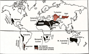
● Off-shore Trade winds: Almost all the deserts are confined within the 15 degree to 30 degree parallel of latitude north and south of the equator.
⮚ They lie in the trade wind belt on the western parts of the continent where Trade winds are off-shore.
⮚ The rain-bearing Trade Winds blow off-shore and the Westerlies that are on-shore blow outside the desert limits.
⮚ Example – Kalahari Desert
● Cold ocean currents: The deserts confined within the 15 degree to 30 degree parallel of latitude north and south of the equator are washed by cold currents which produce a ‘desiccating effect’ so that moisture is not easily condensed into precipitation.
⮚ Example – The desiccating effect of the cold Peruvian Current along the Chilean coast is so pronounced that the mean annual rainfall for the Atacama Desert is not more than 1.3 cm.

● Persistent high atmospheric pressure: The hot deserts lie along the Horse Latitudes or the Subtropical High Pressure Belts where the air is descending, a condition least favorable for precipitation of any kind to take place.
⮚ Example – Sahara Desert in India
● Rain shadow effect: As moist air passes over a mountain range, it expands and cools, precipitating most of its moisture as it rises. As it sweeps down the other side of the mountain range, it warms and compresses, causing high evaporation rates and shedding little rain.
⮚ Example – The Atacama or Peruvian Desert due to rain shadow effect under Andes Mountain Range (along with off-shore trade winds) is the driest of all deserts with less than 2 cm of rainfall annually.
● Continentality: This is the major reason for formation of deserts in temperate regions of the world.
⮚ Amongst the mid-latitude deserts, many are found on plateaus and are at a considerable distance from the sea.
⮚ These regions lying deep within a continent may become deserts simply because air currents reaching them have already traversed vast land distances and lost most of the moisture they originally carried.
⮚ Example – Continentality is a major factor driving arid conditions in the Monte Desert in South AmericaIncorrect
Answer: B
Explanation: Statements 2 and 3 are correct
About Arid or Desert Landforms:
● Deserts: Areas that receive less than 25 centimeters (10 inches) of rain annually are called deserts.
● True deserts: Deserts that are absolutely barren and where nothing grows at all are known as ‘true deserts’.
● About one fifth of the world’s land is made up of deserts.
Reasons for formation of deserts: Deserts are formed at different levels of latitudes i.e. tropical deserts and temperate deserts for various reasons which can be explained as below:

● Off-shore Trade winds: Almost all the deserts are confined within the 15 degree to 30 degree parallel of latitude north and south of the equator.
⮚ They lie in the trade wind belt on the western parts of the continent where Trade winds are off-shore.
⮚ The rain-bearing Trade Winds blow off-shore and the Westerlies that are on-shore blow outside the desert limits.
⮚ Example – Kalahari Desert
● Cold ocean currents: The deserts confined within the 15 degree to 30 degree parallel of latitude north and south of the equator are washed by cold currents which produce a ‘desiccating effect’ so that moisture is not easily condensed into precipitation.
⮚ Example – The desiccating effect of the cold Peruvian Current along the Chilean coast is so pronounced that the mean annual rainfall for the Atacama Desert is not more than 1.3 cm.


● Persistent high atmospheric pressure: The hot deserts lie along the Horse Latitudes or the Subtropical High Pressure Belts where the air is descending, a condition least favorable for precipitation of any kind to take place.
⮚ Example – Sahara Desert in India
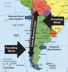
● Rain shadow effect: As moist air passes over a mountain range, it expands and cools, precipitating most of its moisture as it rises. As it sweeps down the other side of the mountain range, it warms and compresses, causing high evaporation rates and shedding little rain.
⮚ Example – The Atacama or Peruvian Desert due to rain shadow effect under Andes Mountain Range (along with off-shore trade winds) is the driest of all deserts with less than 2 cm of rainfall annually.
● Continentality: This is the major reason for formation of deserts in temperate regions of the world.
⮚ Amongst the mid-latitude deserts, many are found on plateaus and are at a considerable distance from the sea.
⮚ These regions lying deep within a continent may become deserts simply because air currents reaching them have already traversed vast land distances and lost most of the moisture they originally carried.
⮚ Example – Continentality is a major factor driving arid conditions in the Monte Desert in South America -
Question 3 of 5
3. Question
3. Consider the following pairs:
Physiographic features of India – Description
1. Bhur – Elevated piece of land situated along banks of Ganga River.
2. Reh – Barren saline land in drier areas of Haryana.
3. Rohi – Fertile tracts on the eastern part of the Thar desert.
4. Bet lands – Bhangar belt in Punjab-Haryana plains.
How many of the above pairs are correctly matched?Correct
Answer: C
Explanation: Only Pair 4 is matched incorrectly
Physiographic features of India – Descriptions
Bhur – Elevated piece of land situated along banks of Ganga river
Reh – Barren saline land in drier areas of Haryana
rohi – Fertile tracts on the eastern part of the Thar desert
Bet lands – Khadar belt in Punjab-Haryana plainsBhur:
● Bhur denotes an elevated piece of land situated along the banks of the Ganga river especially in the upper Ganga-Yamuna Doab.
● This has been formed due to accumulation of wind-blown sands during the hot dry months of the year.
Reh:
● Also known as kallar.
● It comprises barren saline efflorescence of drier areas in Uttar Pradesh and Haryana.
● Reh areas have spread in recent times with increase in irrigation.
Rohi:
● The eastern part of Thar Desert, up-to the Aravali Range is a semi-arid plain known as Rajasthan Bagar.
● It runs in a north-east to south-west direction from the edge of the Aravallis in the east to the 25 cm isohyets in the west.
● It is drained by a number of short seasonal streams originating from the Aravallis and supports agriculture in some patches of fertile tracts called Rohi.
Bet Lands:
● These are Khadar-rich floodplains in regions of Haryana and Punjab, wherein fertile soils are deposited annually, making them very fertile.Incorrect
Answer: C
Explanation: Only Pair 4 is matched incorrectly
Physiographic features of India – Descriptions
Bhur – Elevated piece of land situated along banks of Ganga river
Reh – Barren saline land in drier areas of Haryana
rohi – Fertile tracts on the eastern part of the Thar desert
Bet lands – Khadar belt in Punjab-Haryana plainsBhur:
● Bhur denotes an elevated piece of land situated along the banks of the Ganga river especially in the upper Ganga-Yamuna Doab.
● This has been formed due to accumulation of wind-blown sands during the hot dry months of the year.
Reh:
● Also known as kallar.
● It comprises barren saline efflorescence of drier areas in Uttar Pradesh and Haryana.
● Reh areas have spread in recent times with increase in irrigation.
Rohi:
● The eastern part of Thar Desert, up-to the Aravali Range is a semi-arid plain known as Rajasthan Bagar.
● It runs in a north-east to south-west direction from the edge of the Aravallis in the east to the 25 cm isohyets in the west.
● It is drained by a number of short seasonal streams originating from the Aravallis and supports agriculture in some patches of fertile tracts called Rohi.
Bet Lands:
● These are Khadar-rich floodplains in regions of Haryana and Punjab, wherein fertile soils are deposited annually, making them very fertile. -
Question 4 of 5
4. Question
4. Consider the following pairs:
Dams/Reservoirs – Rivers
1. Shivsagar – Krishna River
2. Gandhi Sagar – Chambal River
3. Gobind Sagar – Sutlej River
How many of the above pairs are correctly matched?Correct
Answer: B
Explanation: Pair 1 is matched incorrectly
Dams/Reservoirs – Rivers
1. Shivsagar – Koyana River
2. Gandhi Sagar – Chambal River
3. Gobind Sagar – Sutlej River
Pair 1 is matched incorrectly:
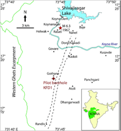
About Koyna River and Dam:
● The Koyna River is a tributary of the Krishna River which originates in Mahabaleshwar, Satara district, western Maharashtra, India.
● It rises near Mahabaleshwar, a famous hill station in the Western Ghats.
● Unlike most of the other rivers in Maharashtra which flow East-West direction, the Koyna river flows in North-South direction.
● The Koyna River is famous for the Koyna Dam and the Koyna Hydroelectric Project.
● Koyna Hydroelectric Project is the 2nd largest completed hydroelectric project in India.
● The reservoir – Shivsagar Lake, is a huge lake of 50 km in length.


Pair 2 is matched correctly:
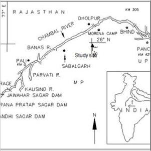
● About Chambal River: The Chambal River is a tributary of the Yamuna River in Central and Northern India, and thus forms part of the drainage system of the Ganges.
● The river flows north-northeast through Madhya Pradesh, running for a time through Rajasthan, then forming the boundary between Rajasthan and Madhya Pradesh before turning southeast to join the Yamuna in Uttar Pradesh state.
Existing Surface Water Projects on Chambal River:
● There are 7 Major (Gandhi Sagar, Rana Pratap Sagar, Jawahar Sagar, Kota Barrage, Parwati Pick-up Weir, Harish Chander Sagar and Gudha Dam)
The Gandhi Sagar Dam
● This is the oldest of the four dams constructed on the Chambal River.
● The Gandhi Sagar Dam is situated on the boundary of Madhya Pradesh and Rajasthan.
● Construction of the dam was finished in 1960.
● The hydroelectric power facility consists of five power generating divisions of 23 MW capacity each.
● The water discharged following electricity generation is used for supplying agricultural lands via Kota Barrage.


Pair 3 is matched correctly:
About Gobind Sagar Dam:
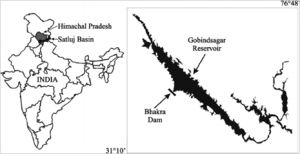
● Gobind Sagar Lake is a reservoir situated in Una and Bilaspur districts of Himachal Pradesh, India.
● It is formed by the Bhakra Dam.
● The reservoir is on the river Sutlej and is named in honour of Guru Gobind Singh, the tenth Sikh guru.
● It is one of the world’s highest gravity dams.
● To maintain the water level, the flow of the river Beas was channelized to Gobind Sagar by the Beas-Sutlej link which was accomplished in 1976.


 Incorrect
Answer: B
Explanation: Pair 1 is matched incorrectly
Dams/Reservoirs – Rivers
1. Shivsagar – Koyana River
2. Gandhi Sagar – Chambal River
3. Gobind Sagar – Sutlej River
Pair 1 is matched incorrectly:
About Koyna River and Dam:
● The Koyna River is a tributary of the Krishna River which originates in Mahabaleshwar, Satara district, western Maharashtra, India.
● It rises near Mahabaleshwar, a famous hill station in the Western Ghats.
● Unlike most of the other rivers in Maharashtra which flow East-West direction, the Koyna river flows in North-South direction.
● The Koyna River is famous for the Koyna Dam and the Koyna Hydroelectric Project.
● Koyna Hydroelectric Project is the 2nd largest completed hydroelectric project in India.
● The reservoir – Shivsagar Lake, is a huge lake of 50 km in length.


Pair 2 is matched correctly:
● About Chambal River: The Chambal River is a tributary of the Yamuna River in Central and Northern India, and thus forms part of the drainage system of the Ganges.
● The river flows north-northeast through Madhya Pradesh, running for a time through Rajasthan, then forming the boundary between Rajasthan and Madhya Pradesh before turning southeast to join the Yamuna in Uttar Pradesh state.
Existing Surface Water Projects on Chambal River:
● There are 7 Major (Gandhi Sagar, Rana Pratap Sagar, Jawahar Sagar, Kota Barrage, Parwati Pick-up Weir, Harish Chander Sagar and Gudha Dam)
The Gandhi Sagar Dam
● This is the oldest of the four dams constructed on the Chambal River.
● The Gandhi Sagar Dam is situated on the boundary of Madhya Pradesh and Rajasthan.
● Construction of the dam was finished in 1960.
● The hydroelectric power facility consists of five power generating divisions of 23 MW capacity each.
● The water discharged following electricity generation is used for supplying agricultural lands via Kota Barrage.


Pair 3 is matched correctly:
About Gobind Sagar Dam:
● Gobind Sagar Lake is a reservoir situated in Una and Bilaspur districts of Himachal Pradesh, India.
● It is formed by the Bhakra Dam.
● The reservoir is on the river Sutlej and is named in honour of Guru Gobind Singh, the tenth Sikh guru.
● It is one of the world’s highest gravity dams.
● To maintain the water level, the flow of the river Beas was channelized to Gobind Sagar by the Beas-Sutlej link which was accomplished in 1976.


-
Question 5 of 5
5. Question
5. This steel plant was set up in 1964 with Russian collaboration. It receives iron ore from the Rourkela region and the wagons on return take coal to Rourkela. Water and Hydel power are supplied by the Damodar Valley Corporation.
Which of the following iron and steel plants is described in the above paragraph?Correct
Answer: A
Explanation:
The development of the iron and steel industry opened the doors to rapid industrial development in India. Almost all sectors of the Indian industry depend heavily on the iron and steel industry for their basic infrastructure.
About Bokaro Steel Plant:
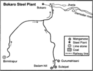
● Bokaro Steel Plant was set up in 1964 at Bokaro with Russian collaboration.
● This plant was set up on the principle of transportation cost minimization by creating the Bokaro-Rourkela combine.
● It receives iron ore from the Rourkela region and the wagons on return take coal to Rourkela.
● Other raw materials come to Bokaro from within a radius of about 350 km.
● Water and Hydel power is supplied by the Damodar Valley Corporation.


Other steel plants:
Steel Plants – Foreign Collaboration
1. Bhilai Steel Plant – • Established with Russian collaboration in Durg District of Chhattisgarh
2. Durgapur Steel Plant – • Set-up in West Bengal, was set up in collaboration with the government of the United Kingdom
3. Tata Iron and Steel Plant (TISCO) – • Private setup of TATA group, 220 km away from KolkataIncorrect
Answer: A
Explanation:
The development of the iron and steel industry opened the doors to rapid industrial development in India. Almost all sectors of the Indian industry depend heavily on the iron and steel industry for their basic infrastructure.
About Bokaro Steel Plant:
● Bokaro Steel Plant was set up in 1964 at Bokaro with Russian collaboration.
● This plant was set up on the principle of transportation cost minimization by creating the Bokaro-Rourkela combine.
● It receives iron ore from the Rourkela region and the wagons on return take coal to Rourkela.
● Other raw materials come to Bokaro from within a radius of about 350 km.
● Water and Hydel power is supplied by the Damodar Valley Corporation.


Other steel plants:
Steel Plants – Foreign Collaboration
1. Bhilai Steel Plant – • Established with Russian collaboration in Durg District of Chhattisgarh
2. Durgapur Steel Plant – • Set-up in West Bengal, was set up in collaboration with the government of the United Kingdom
3. Tata Iron and Steel Plant (TISCO) – • Private setup of TATA group, 220 km away from Kolkata

