TAG: GS 3: ECOLOGY AND ENVIRONMENT
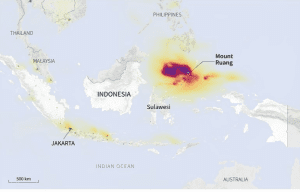
THE CONTEXT: Mount Ruang, located in the province of North Sulawesi, Indonesia, has recently experienced a series of explosive volcanic eruptions.
EXPLANATION:
- This has led to heightened concerns among authorities regarding the safety of the approximately 9,800 residents who used to inhabit Ruang island.
Volcanic Activity and Evacuation
- The volcanic activity escalated rapidly, with eruptions spewing incandescent lava and ash columns kilometers into the sky.
- This prompted the evacuation of all residents from the island.
- The severity of the situation worsened as the mountain continued its eruptions, leading to the closure of the provincial airport in Manado due to volcanic ash.
Evacuation Measures and Relocation Plans
- Authorities raised the alert status in the region to the highest level and issued warnings of potential tsunamis following mountain collapses into surrounding waters.
- As a result, residents were forced to flee not only from Ruang island but also from nearby Tagulandang island, seeking refuge initially before moving to the provincial capital of Manado.
- In response to the crisis, Indonesia announced plans to permanently relocate almost 10,000 residents from the affected islands.
Governmental Response and Mitigation Efforts
- Indonesia’s President instructed the government to prioritize the construction of these homes to facilitate the relocation process.
- Efforts are being made to ensure that the new housing developments are resilient to potential disasters.
Geological Context and Risk Assessment
- The recent eruptions are believed to have been triggered by an increase in seismic activity, including deep-sea earthquakes.
- Indonesia’s location within the “Pacific Ring of Fire” makes it prone to high seismic and volcanic activity.
- The Center for Volcanology and Geological Hazard Mitigation (PVMBG) has warned of potential tsunamis resulting from volcanic material collapsing into the ocean, emphasizing the need for vigilance and proactive measures.
Mount Ruang:
| · Type | Stratovolcano comprising an island |
| · Elevation | 725 meters (2,379 ft) |
| · Location | Sangihe Islands, Indonesia |
| · First Recorded Eruption | 1808 |
| · Notable Eruption and Tsunami | 1871 eruption led to a destructive tsunami, devastating plantations and a large village on Tagulandang |
| · Latest Eruption | April 2024 (ongoing) |


