Day-622
Quiz-summary
0 of 5 questions completed
Questions:
- 1
- 2
- 3
- 4
- 5
Information
DAILY MCQ
You have already completed the quiz before. Hence you can not start it again.
Quiz is loading...
You must sign in or sign up to start the quiz.
You have to finish following quiz, to start this quiz:
Results
0 of 5 questions answered correctly
Your time:
Time has elapsed
You have reached 0 of 0 points, (0)
Categories
- Not categorized 0%
- 1
- 2
- 3
- 4
- 5
- Answered
- Review
-
Question 1 of 5
1. Question
1. Badwater Basin, seen in the news recently, is located in which one of the following countries?
Correct
Answer: D
Explanation:
About Badwater Basin:
● Badwater Basin is an endorheic basin in Death Valley National Park, Death Valley, California (U.S.A).
● It is noted as the lowest point in North America and the United States, with a depth of 282 ft (86 m) below sea level.
● Near Mount Whitney, the highest point in the contiguous United States.
● Badwater Basin’s endorheic nature means water flows into it but not out, typically resulting in rapid evaporation and ephemeral lakes. However, increased precipitation over the past six months has disrupted this pattern.
Recent phenomenon which has been observed:
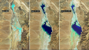
● Recent heavy rainfall, following Hurricane Hilary in August 2023, has altered the landscape of the region and has resulted in the appearance of a Lake.
● The lake initially reduced in size, but surprisingly persisted through the fall and winter seasons. Its recovery in February 2024 was facilitated by a robust atmospheric river that replenished its waters.
● Usually, Death Valley recieves an average annual rainfall of only 51 millimetres but a remarkable 125 mm fell in the past half-year alone, primarily due to two significant weather events. The remnants of Hurricane Hilary deposited 55.88 mm precipitation on August 20, 2023, followed by an atmospheric river bringing another 38.1 mm from February 4-7, 2024.
 Incorrect
Answer: D
Explanation:
About Badwater Basin:
● Badwater Basin is an endorheic basin in Death Valley National Park, Death Valley, California (U.S.A).
● It is noted as the lowest point in North America and the United States, with a depth of 282 ft (86 m) below sea level.
● Near Mount Whitney, the highest point in the contiguous United States.
● Badwater Basin’s endorheic nature means water flows into it but not out, typically resulting in rapid evaporation and ephemeral lakes. However, increased precipitation over the past six months has disrupted this pattern.
Recent phenomenon which has been observed:
● Recent heavy rainfall, following Hurricane Hilary in August 2023, has altered the landscape of the region and has resulted in the appearance of a Lake.
● The lake initially reduced in size, but surprisingly persisted through the fall and winter seasons. Its recovery in February 2024 was facilitated by a robust atmospheric river that replenished its waters.
● Usually, Death Valley recieves an average annual rainfall of only 51 millimetres but a remarkable 125 mm fell in the past half-year alone, primarily due to two significant weather events. The remnants of Hurricane Hilary deposited 55.88 mm precipitation on August 20, 2023, followed by an atmospheric river bringing another 38.1 mm from February 4-7, 2024.
-
Question 2 of 5
2. Question
2. Consider the following statements:
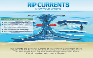
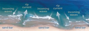
Statement-I: Rip currents are one of the most well-known coastal hazards on beaches around the world.
Statement-II: Rip currents are channeled currents of water flowing away from the shore at surf beaches.
Which one of the following is correct in respect of the above statements?Correct
Answer: A
Explanation: Both Statement-I and Statement-II are correct and Statement-II is the correct explanation for Statement-I
Statement-I is correct:
● Rip currents are present on many beaches every day of the year, but they are usually too slow to be dangerous to beachgoers. However, under certain wave, tide, and beach shape conditions they can increase to dangerous speeds. The strength and speed of a rip current will likely increase as wave height and wave period increase.

● Rip currents are a potential source of danger for people in shallow water with breaking waves, whether this is in seas, oceans or large lakes.
● Rip currents are the proximate cause of 80% of rescues carried out by beach lifeguards.
Statement-II is correct and Statement-II is the correct explanation for Statement-I:
● Rip currents: Rip currents are channeled currents of water flowing away from shore at surf beaches. They typically extend from near the shoreline, through the surf zone and past the line of breaking waves. (The surf zone is the area between the high tide level on the beach to the seaward side of breaking waves.)
How do rip currents form?
● Rip currents form when waves break near the shoreline, piling up water between the breaking waves and the beach. One of the ways this water returns to sea is to form a rip current, a narrow stream of water moving swiftly away from shore, often perpendicular to the shoreline.
● Drowning deaths occur when people pulled offshore are unable to keep themselves afloat and swim to shore. This may be due to any combination of fear, panic, exhaustion, or lack of swimming skills.
● Rip currents are the greatest surf zone hazard to all beachgoers. They can sweep even the strongest swimmer out to sea. Rip currents are particularly dangerous for weak and non-swimmers.Incorrect
Answer: A
Explanation: Both Statement-I and Statement-II are correct and Statement-II is the correct explanation for Statement-I
Statement-I is correct:
● Rip currents are present on many beaches every day of the year, but they are usually too slow to be dangerous to beachgoers. However, under certain wave, tide, and beach shape conditions they can increase to dangerous speeds. The strength and speed of a rip current will likely increase as wave height and wave period increase.
● Rip currents are a potential source of danger for people in shallow water with breaking waves, whether this is in seas, oceans or large lakes.
● Rip currents are the proximate cause of 80% of rescues carried out by beach lifeguards.
Statement-II is correct and Statement-II is the correct explanation for Statement-I:
● Rip currents: Rip currents are channeled currents of water flowing away from shore at surf beaches. They typically extend from near the shoreline, through the surf zone and past the line of breaking waves. (The surf zone is the area between the high tide level on the beach to the seaward side of breaking waves.)
How do rip currents form?
● Rip currents form when waves break near the shoreline, piling up water between the breaking waves and the beach. One of the ways this water returns to sea is to form a rip current, a narrow stream of water moving swiftly away from shore, often perpendicular to the shoreline.
● Drowning deaths occur when people pulled offshore are unable to keep themselves afloat and swim to shore. This may be due to any combination of fear, panic, exhaustion, or lack of swimming skills.
● Rip currents are the greatest surf zone hazard to all beachgoers. They can sweep even the strongest swimmer out to sea. Rip currents are particularly dangerous for weak and non-swimmers. -
Question 3 of 5
3. Question
3. Consider the following statements:
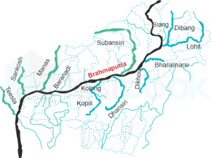
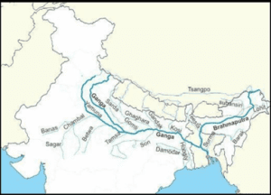
1. River Subansiri is a right bank tributary of the Brahmaputra river.
2. River Gomati is the left bank tributary of the Ganga river.
3. River Zanskar is the left bank tributary of the Indus river.
4. River Vaitarna is a left bank tributary of the Tapi river.
How many of the above statements are correct?Correct
Answer: C
Explanation: Only Statement 4 is incorrect.
Statement 1 is correct:
● Subansiri river also known as the “Gold River” is the largest tributary of the Upper Brahmaputra river.
● It originates from the Tibetan Himalayas and makes its way to India via (Miri Hills) Arunachal Pradesh.
● It flows through Arunachal Pradesh and joins Brahmaputra as its right bank tributary in Assam.
● Subansiri river has been in news for the landslide that took place at Subansiri Lower Hydroelectric Project on the border of Arunachal Pradesh and Assam after a large part of the hill on the left side of the dam collapsed into its reservoir.
Statement 2 is correct:
About Gomati river:
● Gomti is a left bank tributary of the Ganga River and an alluvial river of the Ganga Plain.
● It originates near Mainkot, from Gomat Taala lake (Fulhar Jheel) in Madhotanda, around 30 kilometers from Pilibhit town.
● The river flows through Sitapur, Lucknow, Barabanki, Sultanpur, and Jaunpur before meeting the Ganga at Kaithi, Ghazipur district.
● Tributaries: Kathina, Bhainsi, Sarayan, Gon, Reth, Sai, Pili, and Kalyani
● The total length of the river is about 960 kilometers.
● Gomti is the source of drinking water to Lucknow city.
In news: Recently, over 600 turtles seized from smugglers were released into the Gomti river in forest area of Malihabad near Chandrika Devi Temple.
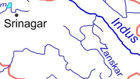
Statement 3 is correct:
Zanskar river:
● The Zanskar River is the major left bank tributary of the Indus River.
● It flows entirely within Ladakh, India.
● It originates northeast of the Great Himalayan range and drains both the Himalayas and the Zanskar Range within the region of Zanskar.
● Zanskar River has two main branches, one is Doda with main source near Pansi-La Pass and other branches are formed by Kargyag River (source near Shingo La) and Tsarap River (source near Baralacha La).
● The river meanders north –westwards through the dramatic gorge of Zanskar and finally meets the Indus River near Nimmu of Ladakh region.
In news: The Chief of the Naval Staff recently inaugurated the Indian Navy’s Chadar Trek expedition at INS Shivaji. It takes place on the frozen Zanskar River in Ladakh.
Statement 4 is incorrect:
● The river Vaitarna is one of the west flowing rivers in the region North of Mumbai and South of the Tapi River.
● The river rises in the Sahyadri hill range at Trimbak in the Nasik district of Maharashtra State and after traversing a distance of about 120 km in Maharashtra towards west, it joins the Arabian Sea. So, it does not join any other river as a tributary.
● Main tributaries: Pinjal, Ganjai, Surya, Daharji, Tansa.
● Significance – Vaitarna supplies much of Mumbai’s drinking water. It is the largest river in the Northern Konkan region and drains Maharashtra’s whole Palghar district.
In news: A fisherman from Maharashtra’s Palghar district was attacked by a bull shark in the Vaitarna river.Incorrect
Answer: C
Explanation: Only Statement 4 is incorrect.
Statement 1 is correct:
● Subansiri river also known as the “Gold River” is the largest tributary of the Upper Brahmaputra river.
● It originates from the Tibetan Himalayas and makes its way to India via (Miri Hills) Arunachal Pradesh.
● It flows through Arunachal Pradesh and joins Brahmaputra as its right bank tributary in Assam.
● Subansiri river has been in news for the landslide that took place at Subansiri Lower Hydroelectric Project on the border of Arunachal Pradesh and Assam after a large part of the hill on the left side of the dam collapsed into its reservoir.
Statement 2 is correct:
About Gomati river:
● Gomti is a left bank tributary of the Ganga River and an alluvial river of the Ganga Plain.
● It originates near Mainkot, from Gomat Taala lake (Fulhar Jheel) in Madhotanda, around 30 kilometers from Pilibhit town.
● The river flows through Sitapur, Lucknow, Barabanki, Sultanpur, and Jaunpur before meeting the Ganga at Kaithi, Ghazipur district.
● Tributaries: Kathina, Bhainsi, Sarayan, Gon, Reth, Sai, Pili, and Kalyani
● The total length of the river is about 960 kilometers.
● Gomti is the source of drinking water to Lucknow city.
In news: Recently, over 600 turtles seized from smugglers were released into the Gomti river in forest area of Malihabad near Chandrika Devi Temple.
Statement 3 is correct:
Zanskar river:
● The Zanskar River is the major left bank tributary of the Indus River.
● It flows entirely within Ladakh, India.
● It originates northeast of the Great Himalayan range and drains both the Himalayas and the Zanskar Range within the region of Zanskar.
● Zanskar River has two main branches, one is Doda with main source near Pansi-La Pass and other branches are formed by Kargyag River (source near Shingo La) and Tsarap River (source near Baralacha La).
● The river meanders north –westwards through the dramatic gorge of Zanskar and finally meets the Indus River near Nimmu of Ladakh region.
In news: The Chief of the Naval Staff recently inaugurated the Indian Navy’s Chadar Trek expedition at INS Shivaji. It takes place on the frozen Zanskar River in Ladakh.
Statement 4 is incorrect:
● The river Vaitarna is one of the west flowing rivers in the region North of Mumbai and South of the Tapi River.
● The river rises in the Sahyadri hill range at Trimbak in the Nasik district of Maharashtra State and after traversing a distance of about 120 km in Maharashtra towards west, it joins the Arabian Sea. So, it does not join any other river as a tributary.
● Main tributaries: Pinjal, Ganjai, Surya, Daharji, Tansa.
● Significance – Vaitarna supplies much of Mumbai’s drinking water. It is the largest river in the Northern Konkan region and drains Maharashtra’s whole Palghar district.
In news: A fisherman from Maharashtra’s Palghar district was attacked by a bull shark in the Vaitarna river. -
Question 4 of 5
4. Question
4. Consider the following pairs:
Islands in news – Countries
1. Socotra Island – Turkey
2. Kuril Island – Japan
3. Agalega Island – Maldives
How many of the above pairs are correctly matched?Correct
Answer: D
Explanation: None of the pair is matched correctly
Pair 1 is matched incorrectly:
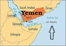
About Socotra Island:
● Socotra is an island of the Republic of Yemen in the Indian Ocean.
● The island of Socotra represents around 95% of the landmass of the Socotra archipelago.
● It lies 380 kilometres south of the Arabian Peninsula and 240 kilometres east of Somalia.
● Despite being controlled by Yemen, it is geographically part of Africa.
● The island is isolated and home to a high number of endemic species. Up to a third of its plant life is endemic. It has been described as “the most alien-looking place on Earth.
● The island measures 132 kilometres in length and 42 kilometres in width.
● In 2008 Socotra was recognised as a UNESCO World Heritage Site.
In news: Recently, a commercial vessel taking tons of fertilizers has sunk in the Southern Red Sea, posing a threat of an environmental catastrophe in the Red Sea including in UNESCO Heritage Site of the Socotra Archipelago.
Pair 2 is matched incorrectly:
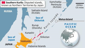
About Kuril Island:
● The Kuril Islands are a volcanic archipelago administered as part of Sakhalin Oblast in the Russian Far East.
● These are a set of four islands situated between the Sea of Okhotsk and the Pacific Ocean near the north of Japan’s northernmost prefecture, Hokkaido.
● Japan refers to them as Northern territories, Russia calls them the Kuril Islands and South Korea named them as Dokdo islands.
● These are part of the Pacific Ring of Fire belt and have over 100 volcanoes, of which 35 are said to be active volcanoes along with hot springs.
● Both Russia and Japan claim sovereignty over them though the islands have been under Russian control since the end of World War II.
● The Soviet Union had seized the islands at the end of World War II and by 1949 had expelled its Japanese residents.
● Tokyo claims that the disputed islands have been part of Japan since the early 19th century.
In news: A massive earthquake shook the island recently. Also there is a possibility of a Japan-Russia diplomatic heat-up on the ownership claims over the island amid the Ukraine war.
Pair 3 is matched incorrectly:
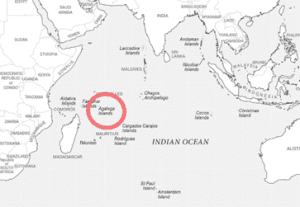
About Agalega Island:
● Agalega islands belong to Mauritius and lie approximately 1,050 km north of Mauritius.
● It is a group of two islands with a total area of 26 sq km and a native population of about 300 people.
In news: Recently, India and Mauritius have jointly inaugurated an airstrip and the St James Jetty on North Agaléga Island in the Indian Ocean.Incorrect
Answer: D
Explanation: None of the pair is matched correctly
Pair 1 is matched incorrectly:
About Socotra Island:
● Socotra is an island of the Republic of Yemen in the Indian Ocean.
● The island of Socotra represents around 95% of the landmass of the Socotra archipelago.
● It lies 380 kilometres south of the Arabian Peninsula and 240 kilometres east of Somalia.
● Despite being controlled by Yemen, it is geographically part of Africa.
● The island is isolated and home to a high number of endemic species. Up to a third of its plant life is endemic. It has been described as “the most alien-looking place on Earth.
● The island measures 132 kilometres in length and 42 kilometres in width.
● In 2008 Socotra was recognised as a UNESCO World Heritage Site.
In news: Recently, a commercial vessel taking tons of fertilizers has sunk in the Southern Red Sea, posing a threat of an environmental catastrophe in the Red Sea including in UNESCO Heritage Site of the Socotra Archipelago.
Pair 2 is matched incorrectly:
About Kuril Island:
● The Kuril Islands are a volcanic archipelago administered as part of Sakhalin Oblast in the Russian Far East.
● These are a set of four islands situated between the Sea of Okhotsk and the Pacific Ocean near the north of Japan’s northernmost prefecture, Hokkaido.
● Japan refers to them as Northern territories, Russia calls them the Kuril Islands and South Korea named them as Dokdo islands.
● These are part of the Pacific Ring of Fire belt and have over 100 volcanoes, of which 35 are said to be active volcanoes along with hot springs.
● Both Russia and Japan claim sovereignty over them though the islands have been under Russian control since the end of World War II.
● The Soviet Union had seized the islands at the end of World War II and by 1949 had expelled its Japanese residents.
● Tokyo claims that the disputed islands have been part of Japan since the early 19th century.
In news: A massive earthquake shook the island recently. Also there is a possibility of a Japan-Russia diplomatic heat-up on the ownership claims over the island amid the Ukraine war.
Pair 3 is matched incorrectly:
About Agalega Island:
● Agalega islands belong to Mauritius and lie approximately 1,050 km north of Mauritius.
● It is a group of two islands with a total area of 26 sq km and a native population of about 300 people.
In news: Recently, India and Mauritius have jointly inaugurated an airstrip and the St James Jetty on North Agaléga Island in the Indian Ocean. -
Question 5 of 5
5. Question
5. Consider the following pairs:
Types of plains – Examples
1. Structural plain – Great Plains of U.S.A.
2. Depositional plain – Plains of North Canada
3. Erosional plain – Ganga-Yamuna Plains of India
How many of the above pairs are correctly matched?Correct
Answer: A
Explanation: Only Pair 1 is matched correctly
Plains:
● Plains are the most important landforms found on the earth surface.
● A plain is nothing but a low-lying relatively flat land surface with very gentle slope and minimum local relief.
● About 55% of the earth’s land surface is occupied by plains.
Classification of plains
On the basis of their mode of formation, plains can be classified as:
a) Structural plain
b) Erosional plains
c) Depositional plains
Pair 1 is matched correctly:
Structural plains:
● They are undisturbed plain landforms on the Earth’s surface.
● They are structurally depressed areas which make up some of the most expanse natural lowlands on Earth.
● Usually, they are formed from horizontally bedded rocks relatively undisturbed by crust movements of the Earth. This type of plain landform is usually created by an uplifting diastrophic movement of a large landmass.
● Examples of structural plain landforms are:
⮚ The plains of the United States of America
⮚ The central lowlands of Australia
Pair 2 is matched incorrectly:
Depositional Plains:
This type of plain landform is formed from materials deposited by rivers, glaciers, waves and wind. The type of sediment which constitutes this plain landform has a significant impact on the fertility and economic relevance of the consequent plain formed by deposition.
Depositional Plains based on the material deposited by rivers: Alluvial plains
● Alluvial plains are vast, sweeping stretches of plain land that are formed by the deposition of sediments called alluvium.
● An alluvial plain usually includes floodplains as part of its area but extends beyond such plains. An alluvial plain represents the pattern of floodplain shift over geological time. As a river flows down mountains or hills, it carries sediments resulting from erosion and transports the sediments to the lower plain. In this way, floodplains continue growing and adding up to form massive stretches of alluvial plains.
⮚ Example – The Indo-Gangetic Plain in India and the Po Valley in Italy are examples of alluvial plains.
Pair 3 is matched incorrectly:
Erosional plains:
● These are plain landforms that are produced from the action of various agents of denudation on an existing landform.
● These agents of denudation – River, running water, glacier and wind, wear out the rugged surface on an existing landform and smoothens them, giving rise to low undulating plain landforms.
● Two major types of plains result from this mode of formation of plain landforms:
⮚ Peneplains (Almost plain): Which results from the action of the various agents of denudation mentioned above, exempting wind.
⮚ Pediplains: Erosional plains formed from wind action
● Examples of plains in this category include:
⮚ Northern Canada plains
⮚ Ice eroded plains of Western AfricaIncorrect
Answer: A
Explanation: Only Pair 1 is matched correctly
Plains:
● Plains are the most important landforms found on the earth surface.
● A plain is nothing but a low-lying relatively flat land surface with very gentle slope and minimum local relief.
● About 55% of the earth’s land surface is occupied by plains.
Classification of plains
On the basis of their mode of formation, plains can be classified as:
a) Structural plain
b) Erosional plains
c) Depositional plains
Pair 1 is matched correctly:
Structural plains:
● They are undisturbed plain landforms on the Earth’s surface.
● They are structurally depressed areas which make up some of the most expanse natural lowlands on Earth.
● Usually, they are formed from horizontally bedded rocks relatively undisturbed by crust movements of the Earth. This type of plain landform is usually created by an uplifting diastrophic movement of a large landmass.
● Examples of structural plain landforms are:
⮚ The plains of the United States of America
⮚ The central lowlands of Australia
Pair 2 is matched incorrectly:
Depositional Plains:
This type of plain landform is formed from materials deposited by rivers, glaciers, waves and wind. The type of sediment which constitutes this plain landform has a significant impact on the fertility and economic relevance of the consequent plain formed by deposition.
Depositional Plains based on the material deposited by rivers: Alluvial plains
● Alluvial plains are vast, sweeping stretches of plain land that are formed by the deposition of sediments called alluvium.
● An alluvial plain usually includes floodplains as part of its area but extends beyond such plains. An alluvial plain represents the pattern of floodplain shift over geological time. As a river flows down mountains or hills, it carries sediments resulting from erosion and transports the sediments to the lower plain. In this way, floodplains continue growing and adding up to form massive stretches of alluvial plains.
⮚ Example – The Indo-Gangetic Plain in India and the Po Valley in Italy are examples of alluvial plains.
Pair 3 is matched incorrectly:
Erosional plains:
● These are plain landforms that are produced from the action of various agents of denudation on an existing landform.
● These agents of denudation – River, running water, glacier and wind, wear out the rugged surface on an existing landform and smoothens them, giving rise to low undulating plain landforms.
● Two major types of plains result from this mode of formation of plain landforms:
⮚ Peneplains (Almost plain): Which results from the action of the various agents of denudation mentioned above, exempting wind.
⮚ Pediplains: Erosional plains formed from wind action
● Examples of plains in this category include:
⮚ Northern Canada plains
⮚ Ice eroded plains of Western Africa