TAG: GS 1: GEOGRAPHY
THE CONTEXT: In response to the growing threat of Glacial Lake Outburst Floods (GLOFs), the Uttarakhand government has initiated efforts to assess the risk posed by potentially hazardous glacial lakes in the region.
EXPLANATION:
- This proactive measure aims to minimize the possibility of GLOF incidents and enhance preparedness for relief and evacuation efforts.
- Rising global temperatures, attributed to climate change, have exacerbated the risk of GLOFs.
- Studies indicate that glacial lakes are expanding and becoming more unstable, posing a significant threat to communities in the Himalayan region.
- Uttarakhand, with its vulnerable geography, has witnessed several GLOF events in recent years, including the catastrophic incidents in the Kedarnath valley in 2013 and Chamoli district in 2021.
National and Regional Concerns:
- The National Disaster Management Authority (NDMA) has identified numerous glacial lakes in the Himalayan states, including Uttarakhand, as potential sources of GLOFs.
- Uttarakhand, in particular, harbors thirteen such lakes, raising concerns about the safety of downstream areas and critical infrastructure.
Assessment and Risk Categorization:
- To address these concerns, the Uttarakhand government has constituted expert teams tasked with evaluating the risk levels of five high-risk glacial lakes in the region.
- These lakes, categorized as ‘A’ level risks, include Vasudhara Tal in Chamoli district and four lakes in Pithoragarh district.
- The assessment aims to classify the lakes based on their potential for GLOF incidents, providing valuable insights for risk mitigation strategies.
- The threat of GLOFs in Uttarakhand is further compounded by projections of increasing surface temperatures in the region.
- Studies indicate a potential rise in the state’s average maximum temperature, exacerbating the risk of glacial melt and GLOF events.
- This underscores the urgent need for proactive measures to address climate-induced hazards and safeguard vulnerable communities.
Global Context and Research Findings:
- GLOFs are not unique to Uttarakhand but pose a significant global challenge, particularly in regions with vulnerable populations and infrastructure.
- Research studies highlight the scale of the risk, with millions of people in India and Pakistan facing potential GLOF threats.
- The severity of the situation underscores the importance of comprehensive risk assessment and mitigation efforts at both national and regional levels.
What is a Glacial Lake and How is it formed?
- It is believed that about 10000 years ago, when the glaciers began retreating, they left behind large deposits of ice in the hollows between drumlins.
- Drumlin is an oval or elongated hill formed by the streamlined movement of glacial ice sheets across rock debris, or till.
- Glacial lakes are formed when a glacier erodes the land (through abrasion and glacial plucking) and creates depression and grooves which are then filled by the meltwater from retreating glaciers.
- However, natural dams, formed out of ice and terminal moraines, can also form glacial lakes.
- Moraine refers to the accumulation of rocks and sediments which have been transported or deposited by ice/glacier.
- Lateral moraines are formed along the sides of a glacier.
- Terminal moraine marks the maximum limit of an icesheet or glacier through formation of a linear ridge of glacial material. When such terminal moraines dam the meltwater from glacial retreat, they result into formation of a moraine-dammed glacial lake.
- The terminal moraine exhibits a characteristic ‘kettle and hummock’ topography. Lakes and marshes are likely to occupy the depressions(kettles). Large angular boulders are found in terminal moraines.
- The south Lhonak glacial lake is a classic example of moraine-dammed glacial lake.

What is Glacial Lake Outburst Flood?
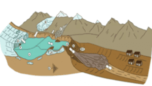
- Glacial Lake Outburst Flood (GLOF) is a type of flood that occurs when water dammed by a glacier, or a moraine is released.
- When glaciers melt, the water in these glacial lakes accumulate behind loose, naturally formed ‘glacial/moraine dams’ made of ice, sand, pebbles and ice residue.
- A catastrophic failure of the dam can release the water over periods of minutes to days causing extreme downstream flooding.
- Peak flows as high as 15,000 cubic meters per second have been recorded in such events.

- The Himalayan states of India sitting at the foothills of the Hindukush-Himalayan ranges are highly susceptible to disasters like Glacial Lake Outburst Floods (GLOFs).
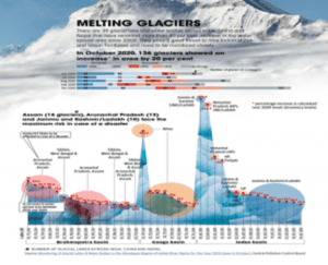
- There exist over 54,000 glaciers in the Third pole which are retreating at alarming rates due to temperature surges in the wake of Climate Change.
- The average temperature in the region has increased by 0.28°C per decade between 1951 and 2020 which has hastened the glacial lake formation as well as the glacial retreat.
- Scientific assessments and studies indicate the higher vulnerability of the Eastern Himalayas to GFOFs as compared to the Western Himalayan region, with the former facing twice the risks than the latter.
- This is attributed to the relatively warmer Eastern Himalayas. Further, it is contended that the threats would triple by 2050 with more hotspots emerging farther west.
OURCE: https://indianexpress.com/article/explained/explained-climate/risk-from-glacial-lake-floods-9249967/
Spread the Word
