Day-553
Quiz-summary
0 of 5 questions completed
Questions:
- 1
- 2
- 3
- 4
- 5
Information
DAILY MCQ
You have already completed the quiz before. Hence you can not start it again.
Quiz is loading...
You must sign in or sign up to start the quiz.
You have to finish following quiz, to start this quiz:
Results
0 of 5 questions answered correctly
Your time:
Time has elapsed
You have reached 0 of 0 points, (0)
Categories
- Not categorized 0%
- 1
- 2
- 3
- 4
- 5
- Answered
- Review
-
Question 1 of 5
1. Question
1. With reference to temperature inversion, consider the following statements:
1. In temperature inversion, temperature decreases with increase in elevation.
2. Temperature inversion at surface level promotes instability in lower layers of atmosphere.
Which of the statements given above is/are correct?Correct
Answer: D
Explanation:
Statement 1 is incorrect:
● Normal lapse rate (NLR): When temperature decreases with increase in elevation, it is called NLR. But sometimes, the situation is reversed and the normal lapse rate is inverted. It is called Inversion of temperature i.e. increase in temperature with increase in elevation.
● Inversion is usually of short duration but quite common nonetheless.
Normal conditions required:
● A long winter night with clear skies and still air is ideal situation for inversion.
● The heat of the day is radiated off during the night, and by early morning hours, the earth is cooler than the air above.
● Example – over polar areas, temperature inversion is normal throughout the year.
Statement 2 is incorrect:
● Surface inversion promotes stability in the lower layers of the atmosphere.
● Smoke and dust particles get collected beneath the inversion layer and spread horizontally to fill the lower strata of the atmosphere.
● Dense fogs in mornings are common occurrences especially during winter season.
● This inversion commonly lasts for few hours until the sun comes up and beings to warm the earth.
Additional Information
Temperature inversion on hilly regions:
● The inversion takes place in hills and mountains due to air drainage.
● Cold air at the hills and mountains, produced during night, flows under the influence of gravity.
● Being heavy and dense, the cold air acts almost like water and moves down the slope to pile up deeply in pockets and valley bottoms with warm air above. This is called air drainage.
● It protects plants from frost damages.Incorrect
Answer: D
Explanation:
Statement 1 is incorrect:
● Normal lapse rate (NLR): When temperature decreases with increase in elevation, it is called NLR. But sometimes, the situation is reversed and the normal lapse rate is inverted. It is called Inversion of temperature i.e. increase in temperature with increase in elevation.
● Inversion is usually of short duration but quite common nonetheless.
Normal conditions required:
● A long winter night with clear skies and still air is ideal situation for inversion.
● The heat of the day is radiated off during the night, and by early morning hours, the earth is cooler than the air above.
● Example – over polar areas, temperature inversion is normal throughout the year.
Statement 2 is incorrect:
● Surface inversion promotes stability in the lower layers of the atmosphere.
● Smoke and dust particles get collected beneath the inversion layer and spread horizontally to fill the lower strata of the atmosphere.
● Dense fogs in mornings are common occurrences especially during winter season.
● This inversion commonly lasts for few hours until the sun comes up and beings to warm the earth.
Additional Information
Temperature inversion on hilly regions:
● The inversion takes place in hills and mountains due to air drainage.
● Cold air at the hills and mountains, produced during night, flows under the influence of gravity.
● Being heavy and dense, the cold air acts almost like water and moves down the slope to pile up deeply in pockets and valley bottoms with warm air above. This is called air drainage.
● It protects plants from frost damages. -
Question 2 of 5
2. Question
2. Consider the following statements:
Statement I: The North Sea records higher salinity despite being located at higher latitude.
Statement II: Ocean currents are major determinants of salinity of oceans/seas.
Which one of the following is correct in respect of the above statements?Correct
Answer: A
Explanation
Both the Statements are correct and Statement II is correct explanation of Statement I:
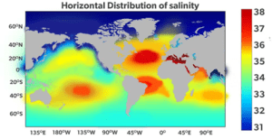
● The North Sea, in spite of its location in higher latitudes, records higher salinity due to more saline water brought by the North Atlantic Drift. While, Baltic Sea records low salinity due to influx of river waters in large quantity.
Horizontal Distribution of Salinity:
• The horizontal distribution of salinity in oceans and seas is influence by several factors.
These include:
● The proximity to major river mouths, where freshwater input can lower salinity levels. Example – Salinity is very low in Black Sea due to enormous fresh water influx by rivers.
● Evaporation rates, which can increase salinity. Example – The Mediterranean Sea records higher salinity due to high evaporation.
● Ocean currents also play a role in distributing salinity horizontally, as they transport water masses with different salinity levels across different regions.
Other factors may be:
● Precipitation
● Influx of river water
● Atmospheric pressure and wind direction
● Global warmingIncorrect
Answer: A
Explanation
Both the Statements are correct and Statement II is correct explanation of Statement I:
● The North Sea, in spite of its location in higher latitudes, records higher salinity due to more saline water brought by the North Atlantic Drift. While, Baltic Sea records low salinity due to influx of river waters in large quantity.
Horizontal Distribution of Salinity:
• The horizontal distribution of salinity in oceans and seas is influence by several factors.
These include:
● The proximity to major river mouths, where freshwater input can lower salinity levels. Example – Salinity is very low in Black Sea due to enormous fresh water influx by rivers.
● Evaporation rates, which can increase salinity. Example – The Mediterranean Sea records higher salinity due to high evaporation.
● Ocean currents also play a role in distributing salinity horizontally, as they transport water masses with different salinity levels across different regions.
Other factors may be:
● Precipitation
● Influx of river water
● Atmospheric pressure and wind direction
● Global warming -
Question 3 of 5
3. Question
3. Consider the following pairs:
Cropping Seasons – Crops
1. Kharif Season – Gram
2. Rabi Season – Cotton
3. Zaid Season – Cucumber
How many of the pairs given above are correctly matched?Correct
Answer: A
Explanation:
Pair 1 is not correctly matched:
● There are three distinct crop seasons in the northern and interior parts of the country, namely Kharif, Rabi and Zaid.
● The Kharif season largely coincides with Southwest Monsoon under which the cultivation of tropical crops, such as rice, cotton, jute, jowar, bajra, and tur is possible.
Pair 2 is not correctly matched:
● The rabi season begins with the onset of winter in October-November and ends in March-April.
● The low-temperature conditions during this season facilitate the cultivation of temperate and subtropical crops such as wheat, gram, and mustard.
Pair 3 is correctly matched:
● Zaid is a short duration summer cropping season beginning after harvesting of rabi crops.
● The cultivation of watermelons, cucumbers, vegetables and fodder crops during this season is done on irrigated lands.
However, this type of distinction in the cropping season does not exist in the southern parts of the country. Here, the temperature is high enough to grow tropical crops during any period in the year provided the soil moisture is available. Therefore, in this region same crops can be grown thrice in an agricultural year provided there is sufficient soil moisture.
 Incorrect
Answer: A
Explanation:
Pair 1 is not correctly matched:
● There are three distinct crop seasons in the northern and interior parts of the country, namely Kharif, Rabi and Zaid.
● The Kharif season largely coincides with Southwest Monsoon under which the cultivation of tropical crops, such as rice, cotton, jute, jowar, bajra, and tur is possible.
Pair 2 is not correctly matched:
● The rabi season begins with the onset of winter in October-November and ends in March-April.
● The low-temperature conditions during this season facilitate the cultivation of temperate and subtropical crops such as wheat, gram, and mustard.
Pair 3 is correctly matched:
● Zaid is a short duration summer cropping season beginning after harvesting of rabi crops.
● The cultivation of watermelons, cucumbers, vegetables and fodder crops during this season is done on irrigated lands.
However, this type of distinction in the cropping season does not exist in the southern parts of the country. Here, the temperature is high enough to grow tropical crops during any period in the year provided the soil moisture is available. Therefore, in this region same crops can be grown thrice in an agricultural year provided there is sufficient soil moisture.
-
Question 4 of 5
4. Question
4. According to the Koeppen’s scheme of classification of Indian climatic regions, ‘As’ type of climatic region refers to:
Correct
Answer: D
Explanation:
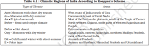
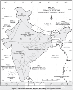
● Koeppen’s scheme of classification of Indian climatic regions divided India into 8 major climatic regions.
● Coromandel coast of Tamil Nadu has been categorised as a ‘Monsoon with dry summer’ climatic region i.e. ‘As’ type of climate.
● Major climatic region according to Koeppen’s climatic classification in India are as given in the table below:
Additional Information
● A climatic region has a homogeneous climatic condition which is the result of a combination of factors. Temperature and rainfall are two important elements which are considered to be decisive in all the schemes of climatic classification. The classification of climate, however, is a complex exercise. There are different schemes of classification of climate.
● Major climatic types of India are based on Koeppen’s scheme.
Koeppen’s scheme
● Koeppen based his scheme of Climatic classification on monthly values of temperature and precipitation.
● He identified five major climatic types, namely:
I. Tropical climates, where mean monthly temperature throughout the year is over 18°C.
II. Dry climates, where precipitation is very low in comparison to temperature, and hence, dry. If dryness is less, it is semi-arid (S); if it is more, the climate is arid (W).
III. Warm temperate climates, where mean temperature of the coldest month is between 18°C and minus 3°C.
IV. Cool temperate climates, where mean temperature of the warmest month is over 10°C, and mean temperature of the coldest month is under minus 3°C.
V. Ice climates, where mean temperature of the warmest month is under 10°C.
● Koeppen used letter symbols to denote climatic types as given above.
● Each type is further sub-divided into sub-types on the basis of seasonal variations in the distributional pattern of rainfall and temperature.
● He used S for semi-arid and W for arid and the following small letters to define sub-types:
⮚ f (sufficient precipitation)
⮚ m (rainforest despite a dry monsoon season)
⮚ w (dryseason in winter)
⮚ h (dry and hot)
⮚ c (less than four months with mean temperature over 10°C)
⮚ g (Gangetic plain).
● Accordingly, India can be divided into nine climatic regions (including steppe climate – Bshw).
● India’s climatic regions are shown in the following map.
 Incorrect
Answer: D
Explanation:
● Koeppen’s scheme of classification of Indian climatic regions divided India into 8 major climatic regions.
● Coromandel coast of Tamil Nadu has been categorised as a ‘Monsoon with dry summer’ climatic region i.e. ‘As’ type of climate.
● Major climatic region according to Koeppen’s climatic classification in India are as given in the table below:
Additional Information
● A climatic region has a homogeneous climatic condition which is the result of a combination of factors. Temperature and rainfall are two important elements which are considered to be decisive in all the schemes of climatic classification. The classification of climate, however, is a complex exercise. There are different schemes of classification of climate.
● Major climatic types of India are based on Koeppen’s scheme.
Koeppen’s scheme
● Koeppen based his scheme of Climatic classification on monthly values of temperature and precipitation.
● He identified five major climatic types, namely:
I. Tropical climates, where mean monthly temperature throughout the year is over 18°C.
II. Dry climates, where precipitation is very low in comparison to temperature, and hence, dry. If dryness is less, it is semi-arid (S); if it is more, the climate is arid (W).
III. Warm temperate climates, where mean temperature of the coldest month is between 18°C and minus 3°C.
IV. Cool temperate climates, where mean temperature of the warmest month is over 10°C, and mean temperature of the coldest month is under minus 3°C.
V. Ice climates, where mean temperature of the warmest month is under 10°C.
● Koeppen used letter symbols to denote climatic types as given above.
● Each type is further sub-divided into sub-types on the basis of seasonal variations in the distributional pattern of rainfall and temperature.
● He used S for semi-arid and W for arid and the following small letters to define sub-types:
⮚ f (sufficient precipitation)
⮚ m (rainforest despite a dry monsoon season)
⮚ w (dryseason in winter)
⮚ h (dry and hot)
⮚ c (less than four months with mean temperature over 10°C)
⮚ g (Gangetic plain).
● Accordingly, India can be divided into nine climatic regions (including steppe climate – Bshw).
● India’s climatic regions are shown in the following map.
-
Question 5 of 5
5. Question
5. With reference to the various types of droughts, consider the following statements:
1. Meteorological drought is a situation when the productivity of a natural ecosystem fails due to shortage of water and as a consequence of ecological distress; damages are induced in the ecosystem.
2. Ecological drought is a situation when there is a prolonged period of inadequate rainfall marked with mal-distribution of the same over time and space.
3. Agricultural drought, also known as soil moisture drought, is characterised by low soil moisture that is necessary to support the crops, thereby resulting in crop failures.
4. Hydrological drought is a situation when the availability of water in different storages and reservoirs like aquifers, lakes, reservoirs, etc. falls below what the precipitation can replenish.
How many of the statements given above are correct?Correct
Answer: B
Explanation:
Statement 1 is incorrect:
● Meteorological drought: It is a situation when there is a prolonged period of inadequate rainfall marked with mal-distribution of the same over time and space.
Statement 2 is incorrect:
● Ecological drought: When the productivity of a natural ecosystem fails due to shortage of water and as a consequence of ecological distress, damages are induced in the ecosystem.
Statement 3 is correct:
● Agricultural drought: It is also known as soil moisture drought, characterised by low soil moisture that is necessary to support the crops, thereby resulting in crop failures. Moreover, if an area has more than 30 percent of its gross cropped area under irrigation, the area is excluded from the drought-prone category.
Statement 4 is correct:
● Hydrological drought: It results when the availability of water in different storages and reservoirs like aquifers, lakes, reservoirs, etc. falls below what the precipitation can replenish.Incorrect
Answer: B
Explanation:
Statement 1 is incorrect:
● Meteorological drought: It is a situation when there is a prolonged period of inadequate rainfall marked with mal-distribution of the same over time and space.
Statement 2 is incorrect:
● Ecological drought: When the productivity of a natural ecosystem fails due to shortage of water and as a consequence of ecological distress, damages are induced in the ecosystem.
Statement 3 is correct:
● Agricultural drought: It is also known as soil moisture drought, characterised by low soil moisture that is necessary to support the crops, thereby resulting in crop failures. Moreover, if an area has more than 30 percent of its gross cropped area under irrigation, the area is excluded from the drought-prone category.
Statement 4 is correct:
● Hydrological drought: It results when the availability of water in different storages and reservoirs like aquifers, lakes, reservoirs, etc. falls below what the precipitation can replenish.