Day-544
Quiz-summary
0 of 5 questions completed
Questions:
- 1
- 2
- 3
- 4
- 5
Information
DAILY MCQ
You have already completed the quiz before. Hence you can not start it again.
Quiz is loading...
You must sign in or sign up to start the quiz.
You have to finish following quiz, to start this quiz:
Results
0 of 5 questions answered correctly
Your time:
Time has elapsed
You have reached 0 of 0 points, (0)
Categories
- Not categorized 0%
- 1
- 2
- 3
- 4
- 5
- Answered
- Review
-
Question 1 of 5
1. Question
1. Consider the following statements:
Statement I: A tropical cyclone is more likely to be developed at the equator in comparison to the tropical regions.
Statement II: Coriolis force is negligible at the equator.
Which one of the following is correct in respect of the above statements?Correct
Answer: D
Explanation:
Statement 1 is incorrect:
● Tropical cyclones cannot originate at the equator because of the lack of a rotating trigger known as the Coriolis force.
Statement 2 is correct: The rotation of the earth about its axis affects the direction of the wind. This force is called the Coriolis force after the French physicist who described it in 1844. It deflects the wind to the right direction in the northern hemisphere and to the left in the southern hemisphere. The deflection is more when the wind velocity is high. The Coriolis force is directly proportional to the angle of latitude. It is maximum at the poles and is absent at the equator.Additional Information
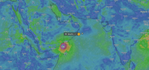
About Tropical Cyclones-
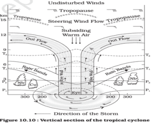
● A Tropical cyclone is a rapid inward air circulation around a low-pressure area.
● Tropical cyclones originate and intensify over warm tropical oceans. The conditions favourable for the formation and intensification of tropical storms are: (i) Large sea surface with temperature higher than 27° C; (ii) Presence of the Coriolis force; (iii) Small variations in the vertical wind speed; (iv) A pre-existing weak low-pressure area or low-level-cyclonic circulation; (v) Upper divergence above the sea level system.
● The energy that intensifies the storm, comes from the condensation process in the towering cumulonimbus clouds, surrounding the centre of the storm.
● The place where a tropical cyclone crosses the coast is called the landfall of the cyclone. The cyclones, which cross 20-degree N latitude generally, recurve and they are more destructive.
● A mature tropical cyclone is characterised by the strong spirally circulating wind around the centre, called the eye. The diameter of the circulating system can vary between 150 and 250 km.
Some examples:
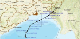
● Cyclone Tej (named by India) made its origin in Arabian Sea while Cyclone Hamoon (named by Iran) made its origin in Bay of Bengal.
 Incorrect
Answer: D
Explanation:
Statement 1 is incorrect:
● Tropical cyclones cannot originate at the equator because of the lack of a rotating trigger known as the Coriolis force.
Statement 2 is correct: The rotation of the earth about its axis affects the direction of the wind. This force is called the Coriolis force after the French physicist who described it in 1844. It deflects the wind to the right direction in the northern hemisphere and to the left in the southern hemisphere. The deflection is more when the wind velocity is high. The Coriolis force is directly proportional to the angle of latitude. It is maximum at the poles and is absent at the equator.Additional Information
About Tropical Cyclones-
● A Tropical cyclone is a rapid inward air circulation around a low-pressure area.
● Tropical cyclones originate and intensify over warm tropical oceans. The conditions favourable for the formation and intensification of tropical storms are: (i) Large sea surface with temperature higher than 27° C; (ii) Presence of the Coriolis force; (iii) Small variations in the vertical wind speed; (iv) A pre-existing weak low-pressure area or low-level-cyclonic circulation; (v) Upper divergence above the sea level system.
● The energy that intensifies the storm, comes from the condensation process in the towering cumulonimbus clouds, surrounding the centre of the storm.
● The place where a tropical cyclone crosses the coast is called the landfall of the cyclone. The cyclones, which cross 20-degree N latitude generally, recurve and they are more destructive.
● A mature tropical cyclone is characterised by the strong spirally circulating wind around the centre, called the eye. The diameter of the circulating system can vary between 150 and 250 km.
Some examples:
● Cyclone Tej (named by India) made its origin in Arabian Sea while Cyclone Hamoon (named by Iran) made its origin in Bay of Bengal.
-
Question 2 of 5
2. Question
2. With reference to limestone caves, consider the following pairs:
Caves – States
1. Borra Caves – Meghalaya
2. Liat Prah Caves – Andhra Pradesh
3. Khangkhui Cave – Manipur
How many of the above pairs are correctly matched?Correct
Answer: A
Explanation:
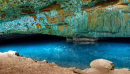
Pair 1 is matched incorrectly:
● The Borra Caves are located on the East Coast of India, in the Ananthagiri hills of the Araku Valley of the Alluri Sitharama Raju district in Andhra Pradesh.
● It is one of India’s longest and the deepest caves extending up to 80 m.
● These caves are considered to be among a rare geological formation and these were formed by the water activity by the Gosthani River.
● Borra Caves were discovered by William King George in 1807.
● There is a naturally formed Shivling inside the caves, which is worshipped by the tribals who live in the nearby forest.
Pair 2 is matched incorrectly:
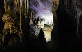
● Krem Liat Prah is the longest natural cave in South Asia.
● Prah (Krem is the Khasi word for “cave”) is one of approximately 150 known caves in the Shnongrim Ridge of the East Jaintia Hills district in the state of Meghalaya, northeast India.
Pair 3 is matched correctly:
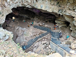
Khangkhui Cave:
● Khangkhui is a Tangkhul Naga village in the North-eastern part of Ukhrul district of Manipur, India.
● It is well known for its ancient limestone cave locally called Khangkhui Mangsor.
● This pre-historic cave is one of the tourist attractions of Ukhrul district.
● The excavation carried out at the Khangkhui Cave yielded evidence of habitation of Stone Age communities.
Incorrect
Answer: A
Explanation:
Pair 1 is matched incorrectly:
● The Borra Caves are located on the East Coast of India, in the Ananthagiri hills of the Araku Valley of the Alluri Sitharama Raju district in Andhra Pradesh.
● It is one of India’s longest and the deepest caves extending up to 80 m.
● These caves are considered to be among a rare geological formation and these were formed by the water activity by the Gosthani River.
● Borra Caves were discovered by William King George in 1807.
● There is a naturally formed Shivling inside the caves, which is worshipped by the tribals who live in the nearby forest.
Pair 2 is matched incorrectly:
● Krem Liat Prah is the longest natural cave in South Asia.
● Prah (Krem is the Khasi word for “cave”) is one of approximately 150 known caves in the Shnongrim Ridge of the East Jaintia Hills district in the state of Meghalaya, northeast India.
Pair 3 is matched correctly:
Khangkhui Cave:
● Khangkhui is a Tangkhul Naga village in the North-eastern part of Ukhrul district of Manipur, India.
● It is well known for its ancient limestone cave locally called Khangkhui Mangsor.
● This pre-historic cave is one of the tourist attractions of Ukhrul district.
● The excavation carried out at the Khangkhui Cave yielded evidence of habitation of Stone Age communities.
-
Question 3 of 5
3. Question
3. Consider the following statements:
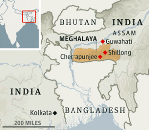
Statement-I: Cherrapunji in Meghalaya plateau displays a bare rocky surface devoid of any permanent vegetation cover.
Statement-II: This area receives maximum rainfall from the Northeast monsoon.
Which one of the following is correct in respect of the above statements?Correct
Answer: C
Explanation:
Statement I is correct: Cherrapunji displays a bare rocky surface devoid of any permanent vegetation cover.
Statement II is incorrect: The area of Meghalaya plateau receives maximum rainfall from the south west monsoon. As a result, the Meghalaya plateau has a highly eroded surface.
About Meghalaya plateau:
● It is a part of the Northeastern plateau which is an extension of the main peninsular plateau.
● It is believed that due to the force exerted by the northeastward movement of the Indian plate at the time of the Himalayan origin, a huge fault was created between the Rajmahal hills and the Meghalaya plateau.
● Later, this depression got filled up by the deposition activity of the numerous rivers.
● Today, the Meghalaya and Karbi Anglong plateau stand detached from the main Peninsular Block.
● The Meghalaya plateau is further sub-divided into three:
⮚ The Garo Hills
⮚ The Khasi Hills
⮚ The Jaintia Hills
● They are named after the tribal groups inhabiting this region.
● An extension of this is also seen in the Karbi Anglong hills of Assam.
● Similar to the Chotanagpur plateau, the Meghalaya plateau is also rich in mineral resources like coal, iron ore, sillimanite, limestone and uranium.
● This area receives maximum rainfall from the south west monsoon.
Incorrect
Answer: C
Explanation:
Statement I is correct: Cherrapunji displays a bare rocky surface devoid of any permanent vegetation cover.
Statement II is incorrect: The area of Meghalaya plateau receives maximum rainfall from the south west monsoon. As a result, the Meghalaya plateau has a highly eroded surface.
About Meghalaya plateau:
● It is a part of the Northeastern plateau which is an extension of the main peninsular plateau.
● It is believed that due to the force exerted by the northeastward movement of the Indian plate at the time of the Himalayan origin, a huge fault was created between the Rajmahal hills and the Meghalaya plateau.
● Later, this depression got filled up by the deposition activity of the numerous rivers.
● Today, the Meghalaya and Karbi Anglong plateau stand detached from the main Peninsular Block.
● The Meghalaya plateau is further sub-divided into three:
⮚ The Garo Hills
⮚ The Khasi Hills
⮚ The Jaintia Hills
● They are named after the tribal groups inhabiting this region.
● An extension of this is also seen in the Karbi Anglong hills of Assam.
● Similar to the Chotanagpur plateau, the Meghalaya plateau is also rich in mineral resources like coal, iron ore, sillimanite, limestone and uranium.
● This area receives maximum rainfall from the south west monsoon.
-
Question 4 of 5
4. Question
4. Consider the following statements:
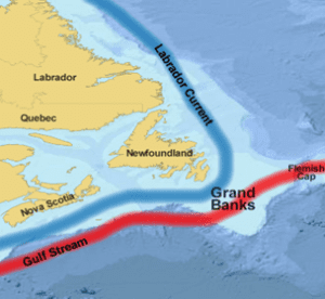
1. The Labrador Current is a cold current in the North Atlantic Ocean that flows from the Arctic Ocean.
2. The mixing of the Humboldt Current and the Labrador Current produces heavy fog and has created one of the richest fishing grounds in the world.
Which of the statements given above is/are correct?Correct
Answer: A
Explanation:
Statement 1 is correct:
● The Labrador Current is a cold current in the North Atlantic Ocean which flows from the Arctic Ocean south along the coast of Labrador and passes around Newfoundland, continuing south along the east coast of Canada near Nova Scotia.
Statement 2 is incorrect:
● Near Nova Scotia, the Labrador Current meets the warm northward moving Gulf Stream.
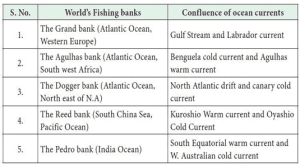
● The mixing of these two currents produces heavy fog and has also created one of the richest fishing grounds in the world. Example- in Grand banks near Newfoundland, Canada.
Additional Information-
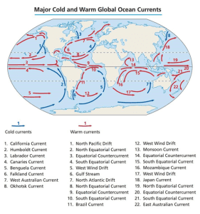
Warm and Cold currents of the world:
Most famous fishing banks in the world due to confluence of warm and cold currents:
Incorrect
Answer: A
Explanation:
Statement 1 is correct:
● The Labrador Current is a cold current in the North Atlantic Ocean which flows from the Arctic Ocean south along the coast of Labrador and passes around Newfoundland, continuing south along the east coast of Canada near Nova Scotia.
Statement 2 is incorrect:
● Near Nova Scotia, the Labrador Current meets the warm northward moving Gulf Stream.
● The mixing of these two currents produces heavy fog and has also created one of the richest fishing grounds in the world. Example- in Grand banks near Newfoundland, Canada.
Additional Information-
Warm and Cold currents of the world:
Most famous fishing banks in the world due to confluence of warm and cold currents:
-
Question 5 of 5
5. Question
5. Consider the following statements:
1. Ken River passes through Panna Tiger Reserve.
2. Rajaji Tiger Reserve is bisected by Ramganga River.
3. Mahanadi flows through Satkosia Tiger Reserve.
4. Sharda River runs through Valmiki Tiger Reserve.
How many of the statements given above are correct?Correct
Answer: B
Explanation:
Statement 1 is correct:
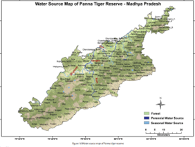
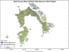
Ken River passes through Panna Tiger Reserve. As shown in figure given below:
About Panna Tiger Reserve:
● Situated in the Vindhyan mountain range in the northern part of Madhya Pradesh,
● Panna Tiger Reserve is spread over the Panna and Chhatarpur districts.
● The terrain here consists of extensive plateaus and gorges.
● This reserve contains the last remaining tiger habitat of North Madhya Pradesh.
● Flowing from the south to the north through the reserve is the River Ken.
● These forests along with Ken Gharial Sanctuary form a significant part of the catchment area of this river.
● This river is one of the sixteen perennial rivers of Madhya Pradesh.
● It is the lifeline of this reserve and is the least polluted of Yamuna’s tributaries.
● The path of the meandering Ken offers some spectacular scenery.
● The reserve is also dotted with two thousand year-old rock paintings.
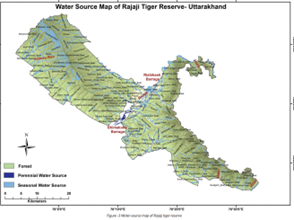
Statement 2 is incorrect: Rajaji Tiger Reserve is bisected by River Ganga, not by River Ramganga. River Ramganga passes through Jim Corbett Tiger Reserve.
About Rajaji tiger reserve:
● Rajaji Tiger Reserve is situated along the hills and foothills of Shiwalik ranges and represents the Shiwalik eco-system.
● The area is covered with diverse forest types ranging from semi-evergreen to deciduous and from mixed broad-leaved to Terai grassland and has been classified as Indus-Ganges Monsoon Forest type.
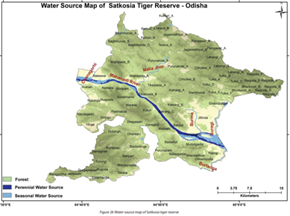
Statement 3 is correct: Mahanadi River flows through Satkosia Tiger reserve of Odisha.
About Satkosia Tiger Reserve:
● It is a tiger reserve located on the border of Angul and Nayagarh district of Odisha, covering an area of 988.30 km².
● It is located where the Mahanadi River passes through a 22 km long gorge in the Eastern Ghats Mountains.
● The tiger reserve is located in the Eastern Highlands moist deciduous forests eco-region.
Statement 4 is incorrect: River Sharda is a major river flowing through Pilibhit Tiger Reserve, while Narayani River is a major river flowing through Valmiki Tiger Reserve.
About Pilibhit tiger reserve:
● Pilibhit Tiger Reserve is located in Pilibhit district, Lakhimpur Kheri District and Bahraich District of Uttar Pradesh.
● The Pilibhit Tiger Reserve is one of the finest examples of the exceedingly diverse and productive Terai ecosystems.
● Pilibhit Tiger Reserve was declared in September 2008 based on its special type of ecosystem with vast open spaces and sufficient feed for the elegant predators. It is India’s 45th Tiger Reserve Project.
● The northern edge of the reserve lies along the Indo-Nepal border while the southern boundary is marked by the river Sharada and Khakra.
Incorrect
Answer: B
Explanation:
Statement 1 is correct:
Ken River passes through Panna Tiger Reserve. As shown in figure given below:
About Panna Tiger Reserve:
● Situated in the Vindhyan mountain range in the northern part of Madhya Pradesh,
● Panna Tiger Reserve is spread over the Panna and Chhatarpur districts.
● The terrain here consists of extensive plateaus and gorges.
● This reserve contains the last remaining tiger habitat of North Madhya Pradesh.
● Flowing from the south to the north through the reserve is the River Ken.
● These forests along with Ken Gharial Sanctuary form a significant part of the catchment area of this river.
● This river is one of the sixteen perennial rivers of Madhya Pradesh.
● It is the lifeline of this reserve and is the least polluted of Yamuna’s tributaries.
● The path of the meandering Ken offers some spectacular scenery.
● The reserve is also dotted with two thousand year-old rock paintings.
Statement 2 is incorrect: Rajaji Tiger Reserve is bisected by River Ganga, not by River Ramganga. River Ramganga passes through Jim Corbett Tiger Reserve.
About Rajaji tiger reserve:
● Rajaji Tiger Reserve is situated along the hills and foothills of Shiwalik ranges and represents the Shiwalik eco-system.
● The area is covered with diverse forest types ranging from semi-evergreen to deciduous and from mixed broad-leaved to Terai grassland and has been classified as Indus-Ganges Monsoon Forest type.
Statement 3 is correct: Mahanadi River flows through Satkosia Tiger reserve of Odisha.
About Satkosia Tiger Reserve:
● It is a tiger reserve located on the border of Angul and Nayagarh district of Odisha, covering an area of 988.30 km².
● It is located where the Mahanadi River passes through a 22 km long gorge in the Eastern Ghats Mountains.
● The tiger reserve is located in the Eastern Highlands moist deciduous forests eco-region.
Statement 4 is incorrect: River Sharda is a major river flowing through Pilibhit Tiger Reserve, while Narayani River is a major river flowing through Valmiki Tiger Reserve.
About Pilibhit tiger reserve:
● Pilibhit Tiger Reserve is located in Pilibhit district, Lakhimpur Kheri District and Bahraich District of Uttar Pradesh.
● The Pilibhit Tiger Reserve is one of the finest examples of the exceedingly diverse and productive Terai ecosystems.
● Pilibhit Tiger Reserve was declared in September 2008 based on its special type of ecosystem with vast open spaces and sufficient feed for the elegant predators. It is India’s 45th Tiger Reserve Project.
● The northern edge of the reserve lies along the Indo-Nepal border while the southern boundary is marked by the river Sharada and Khakra.