Day-527
Quiz-summary
0 of 5 questions completed
Questions:
- 1
- 2
- 3
- 4
- 5
Information
To attempt the Quiz, simply click on START Button.
You have already completed the quiz before. Hence you can not start it again.
Quiz is loading...
You must sign in or sign up to start the quiz.
You have to finish following quiz, to start this quiz:
Results
0 of 5 questions answered correctly
Your time:
Time has elapsed
You have reached 0 of 0 points, (0)
| Average score |
|
| Your score |
|
Categories
- Not categorized 0%
- 1
- 2
- 3
- 4
- 5
- Answered
- Review
-
Question 1 of 5
1. Question
2 points1. Consider the following pairs:
Rivers – Sea/Ocean they drain into
1. Amazon – Atlantic Ocean
2. Nile – Red Sea
3. Danube – Black Sea
4. Orange – Indian Ocean
How many of the above pairs are correctly matched?Correct
Answer: B
Explanation:
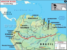
Pair 1 is matched correctly: Amazon River falls into the Atlantic Ocean.
Amazon River: It is the biggest river of South America and the largest drainage system in the world in terms of the volume of its flow and the area of its basin.
The total length of the river is at least 4,000 miles (6,400 km), which makes it slightly shorter than the Nile River.

Pair 2 is matched incorrectly: Nile River falls into Mediterranean Sea.
Nile River
● Nile River is the longest river in the world, called the father of African rivers.
● It rises south of the Equator and flows northward through northeastern Africa to drain into the Mediterranean Sea.
● It has a length of about 4,132 miles (6,650 kilometres) and drains an area estimated at 1,293,000 square miles (3,349,000 square kilometres).
● Its basin includes parts of Tanzania, Burundi, Rwanda, the Democratic Republic of the Congo, Kenya, Uganda, South Sudan, Ethiopia, Sudan, and the cultivated part of Egypt.
● Its most distant source is the Kagera River in Burundi.
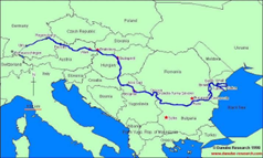
Pair 3 is matched correctly: Danube River falls into Black Sea.
Danube River:
● It is the second longest in Europe after the Volga.
● It rises in the Black Forest mountains of western Germany and flows for some 1,770 miles (2,850 km) to its mouth on the Black Sea.
● Along its course it passes through 10 countries:
● Germany, Austria, Slovakia, Hungary, Croatia, Serbia, Bulgaria, Romania, Moldova, and Ukraine.
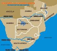
Pair 4 is matched incorrectly: Orange River falls into the Atlantic Ocean.
Orange River:
● Orange River, river in southern Africa, one of the longest rivers on the continent and one of the longest south of the Tropic of Capricorn.
● After rising in the Lesotho Highlands, less than 125 miles (200 kilometres) from the Indian Ocean, the river flows to the Atlantic Ocean in a generally westerly direction for some 1,300 miles.
● The Orange traverses the veld region of South Africa, after which it defines the southern limit of the Kalahari and bisects the southern Namib before draining into the Atlantic at Alexander Bay.
● Along its course the river forms the eastern boundary of the South African province of Free State, as well as the boundary between Namibia and South Africa.
Incorrect
Answer: B
Explanation:
Pair 1 is matched correctly: Amazon River falls into the Atlantic Ocean.
Amazon River: It is the biggest river of South America and the largest drainage system in the world in terms of the volume of its flow and the area of its basin.
The total length of the river is at least 4,000 miles (6,400 km), which makes it slightly shorter than the Nile River.
Pair 2 is matched incorrectly: Nile River falls into Mediterranean Sea.
Nile River
● Nile River is the longest river in the world, called the father of African rivers.
● It rises south of the Equator and flows northward through northeastern Africa to drain into the Mediterranean Sea.
● It has a length of about 4,132 miles (6,650 kilometres) and drains an area estimated at 1,293,000 square miles (3,349,000 square kilometres).
● Its basin includes parts of Tanzania, Burundi, Rwanda, the Democratic Republic of the Congo, Kenya, Uganda, South Sudan, Ethiopia, Sudan, and the cultivated part of Egypt.
● Its most distant source is the Kagera River in Burundi.
Pair 3 is matched correctly: Danube River falls into Black Sea.
Danube River:
● It is the second longest in Europe after the Volga.
● It rises in the Black Forest mountains of western Germany and flows for some 1,770 miles (2,850 km) to its mouth on the Black Sea.
● Along its course it passes through 10 countries:
● Germany, Austria, Slovakia, Hungary, Croatia, Serbia, Bulgaria, Romania, Moldova, and Ukraine.
Pair 4 is matched incorrectly: Orange River falls into the Atlantic Ocean.
Orange River:
● Orange River, river in southern Africa, one of the longest rivers on the continent and one of the longest south of the Tropic of Capricorn.
● After rising in the Lesotho Highlands, less than 125 miles (200 kilometres) from the Indian Ocean, the river flows to the Atlantic Ocean in a generally westerly direction for some 1,300 miles.
● The Orange traverses the veld region of South Africa, after which it defines the southern limit of the Kalahari and bisects the southern Namib before draining into the Atlantic at Alexander Bay.
● Along its course the river forms the eastern boundary of the South African province of Free State, as well as the boundary between Namibia and South Africa.
-
Question 2 of 5
2. Question
2 points2. Consider the following statements:
Statement-I: Generally, tropical cyclones are not observed in the South Atlantic Ocean.
Statement-II: Sea surface water temperatures in the tropical southern Atlantic Ocean are cooler than those in the tropical north Atlantic Ocean.
Which one of the following is correct in respect of the above statements?Correct
Answer: A
Explanation:
Tropical cyclones are violent storms that originate over oceans in tropical areas and move over to the coastal areas bringing about large scale destruction caused by violent winds, very heavy rainfall and storm surges.
The conditions favourable for the formation and intensification of tropical storms are: (i) Large sea surface with temperature higher than 27° C; (ii) Presence of the Coriolis force; (iii) Small variations in the vertical wind speed; (iv) A pre-existing weak low-pressure area or low-level-cyclonic circulation; (v) Upper divergence above the sea level system.
Tropical cyclones are unusual in South Atlantic Ocean because:
● Strong wind shear in the Troposphere, which disrupts the formation of these cyclones, as well as a lack of weather disturbances favourable for development in the South Atlantic Ocean (such as the tropical waves common in the southern North Atlantic) make any strong tropical system extremely rare.
● The Inter Tropical Convergence Zone (ITCZ), another potential breeding ground, drops one to two degrees south of the equator, not far enough from the equator for the spin of the Coriolis force to aid development.
● Water temperatures in the tropics of the southern Atlantic are cooler than those in the tropical north Atlantic.Incorrect
Answer: A
Explanation:
Tropical cyclones are violent storms that originate over oceans in tropical areas and move over to the coastal areas bringing about large scale destruction caused by violent winds, very heavy rainfall and storm surges.
The conditions favourable for the formation and intensification of tropical storms are: (i) Large sea surface with temperature higher than 27° C; (ii) Presence of the Coriolis force; (iii) Small variations in the vertical wind speed; (iv) A pre-existing weak low-pressure area or low-level-cyclonic circulation; (v) Upper divergence above the sea level system.
Tropical cyclones are unusual in South Atlantic Ocean because:
● Strong wind shear in the Troposphere, which disrupts the formation of these cyclones, as well as a lack of weather disturbances favourable for development in the South Atlantic Ocean (such as the tropical waves common in the southern North Atlantic) make any strong tropical system extremely rare.
● The Inter Tropical Convergence Zone (ITCZ), another potential breeding ground, drops one to two degrees south of the equator, not far enough from the equator for the spin of the Coriolis force to aid development.
● Water temperatures in the tropics of the southern Atlantic are cooler than those in the tropical north Atlantic. -
Question 3 of 5
3. Question
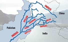
2 points3. With respect to the “Chenab” river, consider the following statements:
1. It originates near the Bara Lacha Pass in the Zaskar Range.
2. It is the second largest tributary of the Indus river.
3. The river is formed by the confluence of two rivers, the Chandra and the Bhaga.
How many of the above statements are incorrect?Correct
Answer: A
Explanation:
Statement 1 is correct: Chenab is a major river that flows in India and Pakistan, and is one of the 5 major rivers of the Punjab region.
It originates from near the Bara Lacha Pass in the Lahul-Spiti part of the Zaskar Range.
Statement 2 is incorrect: It is the largest tributary of river Indus.
Statement 3 is correct:
The river is formed by the confluence of two rivers, the Chandra and the Bhaga, at Tandi, 8 km southwest of Keylong, in the Lahaul and Spiti district in the Indian state of Himachal Pradesh.
Incorrect
Answer: A
Explanation:
Statement 1 is correct: Chenab is a major river that flows in India and Pakistan, and is one of the 5 major rivers of the Punjab region.
It originates from near the Bara Lacha Pass in the Lahul-Spiti part of the Zaskar Range.
Statement 2 is incorrect: It is the largest tributary of river Indus.
Statement 3 is correct:
The river is formed by the confluence of two rivers, the Chandra and the Bhaga, at Tandi, 8 km southwest of Keylong, in the Lahaul and Spiti district in the Indian state of Himachal Pradesh.
-
Question 4 of 5
4. Question
2 points4. Consider the following statements:
Statement-I: Shallow focus earthquakes are observed along the Circum-Pacific zone.
Statement-II: Pacific plate being the heavier plate subducts under surrounding continental plates.
Which one of the following is correct in respect of the above statements?Correct
Answer: D
Explanation:
● Statement I is incorrect: Deep focus earthquakes are observed along the Circum-Pacific zone as there are converging plate movements/boundaries.
● Statement II is correct: Pacific plate being the heavier plate (as it is oceanic plate) subducts under surrounding continental plates such as North American plate, South American plate and Eurasian plate.
Note: Shallow focus earthquakes are observed along divergent plate boundaries. E.g. Mid-oceanic regions.Incorrect
Answer: D
Explanation:
● Statement I is incorrect: Deep focus earthquakes are observed along the Circum-Pacific zone as there are converging plate movements/boundaries.
● Statement II is correct: Pacific plate being the heavier plate (as it is oceanic plate) subducts under surrounding continental plates such as North American plate, South American plate and Eurasian plate.
Note: Shallow focus earthquakes are observed along divergent plate boundaries. E.g. Mid-oceanic regions. -
Question 5 of 5
5. Question
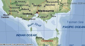
2 points5. Consider the following statements:
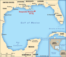
1. The Bass Strait connects the Caribbean Sea with the Gulf of Mexico.
2. The Yucatan Channel separates the island state of Tasmania from the Australian mainland.
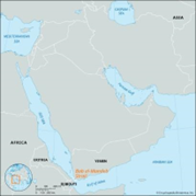
3. The Bab al-Mandab Strait connects the Red Sea with the Gulf of Aden.
How many of the above statements are correct?Correct
Answer: A
Explanation:
Statement 1 is incorrect:
The Bass Strait is a strait separating the island state of Tasmania from the Australian mainland. The strait provides the most direct waterway between the Great Australian Bight and the Tasman Sea and is also the only maritime route into the economically prominent Port Phillip Bay.
Statement 2 is incorrect:
The Yucatán Channel separates Cuba from the Yucatan Peninsula of Mexico and links the Caribbean Sea with the Gulf of Mexico.
Statement 3 is correct:
● The Bab-el-Mandeb also known as the Gate of Grief is a strait between Yemen on the Arabian Peninsula, Djibouti, and Eritrea in the Horn of Africa.
● It connects the Red Sea to the Gulf of Aden.
Incorrect
Answer: A
Explanation:
Statement 1 is incorrect:
The Bass Strait is a strait separating the island state of Tasmania from the Australian mainland. The strait provides the most direct waterway between the Great Australian Bight and the Tasman Sea and is also the only maritime route into the economically prominent Port Phillip Bay.
Statement 2 is incorrect:
The Yucatán Channel separates Cuba from the Yucatan Peninsula of Mexico and links the Caribbean Sea with the Gulf of Mexico.
Statement 3 is correct:
● The Bab-el-Mandeb also known as the Gate of Grief is a strait between Yemen on the Arabian Peninsula, Djibouti, and Eritrea in the Horn of Africa.
● It connects the Red Sea to the Gulf of Aden.