Day-652 | Daily MCQs | UPSC Prelims | GEOGRAPHY
Day-652
Quiz-summary
0 of 5 questions completed
Questions:
- 1
- 2
- 3
- 4
- 5
Information
DAILY MCQ
You have already completed the quiz before. Hence you can not start it again.
Quiz is loading...
You must sign in or sign up to start the quiz.
You have to finish following quiz, to start this quiz:
Results
0 of 5 questions answered correctly
Your time:
Time has elapsed
You have reached 0 of 0 points, (0)
Categories
- Not categorized 0%
- 1
- 2
- 3
- 4
- 5
- Answered
- Review
-
Question 1 of 5
1. Question
1. Wolframite and scheelite, are the rich sources of which one of the following?
Correct
Answer: B
Explanation:
● The average reported concentration of tungsten in the Earth’s crust is about 1.5 ppm.
● The ores from which tungsten is extracted are wolframite and scheelite, with 76.5% and 80.6% tungsten trioxide (WO3), respectively.
● Scheelite is calcium tungstate (CaWO4), and wolframite is a mixture of ferrous tungstate (FeWO4) and manganese tungstate (MnWO4).Incorrect
Answer: B
Explanation:
● The average reported concentration of tungsten in the Earth’s crust is about 1.5 ppm.
● The ores from which tungsten is extracted are wolframite and scheelite, with 76.5% and 80.6% tungsten trioxide (WO3), respectively.
● Scheelite is calcium tungstate (CaWO4), and wolframite is a mixture of ferrous tungstate (FeWO4) and manganese tungstate (MnWO4). -
Question 2 of 5
2. Question
2. Consider the following trees:
1. Amla (Phyllanthus emblica)
2. Tendu (Diospyros melanoxylon)
3. Mango (Mangifera indica)
How many of the above are deciduous trees?Correct
Answer: B
Explanation: Amla and Tendu are the deciduous trees.
Tropical deciduous forests of India-
● These are the most widespread forests in India.
● They are also called the monsoon forests.
● They spread over regions which receive rainfall between 70-200 cm.
● On the basis of the availability of water, these forests are further divided into moist and dry deciduous.
● The Moist deciduous forests are more pronounced in the regions which record rainfall between 100-200 cm.
● These forests are found in the northeastern states along the foothills of Himalayas, eastern slopes of the Western Ghats and Odisha.
● Teak, sal, shisham, hurra, tendu, mahua, amla, semul, kusum, and sandalwood etc. are the main species of these forests.
● Dry deciduous forest covers vast areas of the country, where rainfall ranges between 70 -100 cm.
● On the wetter margins, it has a transition to the moist deciduous, while on the drier margins to thorn forests.
● These forests are found in rainier areas of the Peninsula and the plains of Uttar Pradesh and Bihar.
Note: Mango is considered vegetation belonging to Tropical Semi-Evergreen Forests, along with others such as – aini, semul, gutel, mundane, hopea, kadam, laurel, rosewood, kusum, white cedar, hillock etc.Incorrect
Answer: B
Explanation: Amla and Tendu are the deciduous trees.
Tropical deciduous forests of India-
● These are the most widespread forests in India.
● They are also called the monsoon forests.
● They spread over regions which receive rainfall between 70-200 cm.
● On the basis of the availability of water, these forests are further divided into moist and dry deciduous.
● The Moist deciduous forests are more pronounced in the regions which record rainfall between 100-200 cm.
● These forests are found in the northeastern states along the foothills of Himalayas, eastern slopes of the Western Ghats and Odisha.
● Teak, sal, shisham, hurra, tendu, mahua, amla, semul, kusum, and sandalwood etc. are the main species of these forests.
● Dry deciduous forest covers vast areas of the country, where rainfall ranges between 70 -100 cm.
● On the wetter margins, it has a transition to the moist deciduous, while on the drier margins to thorn forests.
● These forests are found in rainier areas of the Peninsula and the plains of Uttar Pradesh and Bihar.
Note: Mango is considered vegetation belonging to Tropical Semi-Evergreen Forests, along with others such as – aini, semul, gutel, mundane, hopea, kadam, laurel, rosewood, kusum, white cedar, hillock etc. -
Question 3 of 5
3. Question
3. Consider the following statements:
1. Aravalli Mountain range lies in only two states.
2. Rajmahal hills lie in only one state.
3. Cardamom hills lie in only two states.
How many of the above given statements are incorrect?Correct
Answer: A
Explanation:
Statement 1 is incorrect:
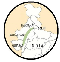
Aravalli Mountain range:
● The Aravalli Range is a mountain range in Northern-Western India, running approximately 670 km in a south-west direction.
● It starts near Delhi, passing through southern Haryana, Rajasthan, and ends in Ahmedabad Gujarat. (So, it passes through three States and one U.T. i.e. New Delhi)
● The highest peak is Guru Shikhar in Mount Abu at 1,722 m (5,650 ft).
● The Aravalli Range is arguably one of the oldest geological features on Earth, having its origin in the Proterozoic era.
● It is rich in natural resources and serves as check to the growth of the western desert.
Statement 2 is correct:
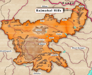
The Rajmahal Hills:
● The Rajmahal Hills are located in the Santhal Pargana division of Jharkhand, India.
● They were located on the northern margin of the Gondwana supercontinent, and its hills are today inhabited by the Sauria Paharia people whilst its valleys are dominated by the Santhal people.
● The hills span over an area of 2,600 km square.
● The hills trend north-south with an average elevation of 200–300 m (660–980 ft), from the Sahibganj district to the Dumka district.
● The River Ganges wanders around the hills changing the direction of flow from east to south.
Statement 3 is correct:
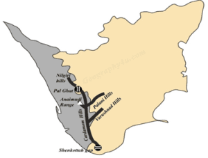
The Cardamom Hills:
● Cardamom Hills are the part of the Western Ghats located in the south Indian states of Kerala and Tamil Nadu.
● The average elevation of the Cardamom Hills is 2637 meters or 8652 feet.
⮚ Anai Mudi is the highest peak in the Cardamom Hills.
● Some of its eastern peaks are 1,370 meter high.
● The Cardamom Hills produces tea, coffee, teak, bamboo and cardamom.
● The hills are under consideration by the UNESCO World Heritage Committee for the selection as the World Heritage Site.
 Incorrect
Answer: A
Explanation:
Statement 1 is incorrect:
Aravalli Mountain range:
● The Aravalli Range is a mountain range in Northern-Western India, running approximately 670 km in a south-west direction.
● It starts near Delhi, passing through southern Haryana, Rajasthan, and ends in Ahmedabad Gujarat. (So, it passes through three States and one U.T. i.e. New Delhi)
● The highest peak is Guru Shikhar in Mount Abu at 1,722 m (5,650 ft).
● The Aravalli Range is arguably one of the oldest geological features on Earth, having its origin in the Proterozoic era.
● It is rich in natural resources and serves as check to the growth of the western desert.
Statement 2 is correct:
The Rajmahal Hills:
● The Rajmahal Hills are located in the Santhal Pargana division of Jharkhand, India.
● They were located on the northern margin of the Gondwana supercontinent, and its hills are today inhabited by the Sauria Paharia people whilst its valleys are dominated by the Santhal people.
● The hills span over an area of 2,600 km square.
● The hills trend north-south with an average elevation of 200–300 m (660–980 ft), from the Sahibganj district to the Dumka district.
● The River Ganges wanders around the hills changing the direction of flow from east to south.
Statement 3 is correct:
The Cardamom Hills:
● Cardamom Hills are the part of the Western Ghats located in the south Indian states of Kerala and Tamil Nadu.
● The average elevation of the Cardamom Hills is 2637 meters or 8652 feet.
⮚ Anai Mudi is the highest peak in the Cardamom Hills.
● Some of its eastern peaks are 1,370 meter high.
● The Cardamom Hills produces tea, coffee, teak, bamboo and cardamom.
● The hills are under consideration by the UNESCO World Heritage Committee for the selection as the World Heritage Site.
-
Question 4 of 5
4. Question
4. Consider the following statements about Kaladan Multi-Modal Transit Transport Project:
1. It seeks to connect Kolkata to Sittwe port in Myanmar.
2. It further seeks to connect Sittwe to Paletwa in Thailand through inland water transport on Kaladan river.
Which of the statements given above is/are correct?Correct
Answer: A
Explanation:
Statement 1 is correct and Statement 2 is incorrect:
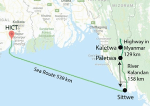
About Kaladan Multi-Modal Transit Transport Project:
● Kaladan Project would link India and Myanmar via the Bay of Bengal.
● It was jointly identified by India and Myanmar to create a multi-modal mode of transport for the shipment of cargo from the eastern ports of India to Myanmar as well as to the North-Eastern part of India through Myanmar.
● It is being constructed by India under the Grant in Aid Scheme.
● Once completed, it will link Kolkata with the Sittwe seaport in Rakhine state in Myanmar, primarily over the Bay of Bengal – covering over 500 km.
● The project envisaged four important stages:
⮚ Kolkata to Sittwe waterway
⮚ Sittwe to Paletwa inland (River Kaladan) waterway (Paletwa is in Myanmar itself)
⮚ Paletwa to India-Myanmar border post in Myanmar
⮚ Finally, linking the road to Lawngtlai in Mizoramas part of the project’s last leg
 Incorrect
Answer: A
Explanation:
Statement 1 is correct and Statement 2 is incorrect:
About Kaladan Multi-Modal Transit Transport Project:
● Kaladan Project would link India and Myanmar via the Bay of Bengal.
● It was jointly identified by India and Myanmar to create a multi-modal mode of transport for the shipment of cargo from the eastern ports of India to Myanmar as well as to the North-Eastern part of India through Myanmar.
● It is being constructed by India under the Grant in Aid Scheme.
● Once completed, it will link Kolkata with the Sittwe seaport in Rakhine state in Myanmar, primarily over the Bay of Bengal – covering over 500 km.
● The project envisaged four important stages:
⮚ Kolkata to Sittwe waterway
⮚ Sittwe to Paletwa inland (River Kaladan) waterway (Paletwa is in Myanmar itself)
⮚ Paletwa to India-Myanmar border post in Myanmar
⮚ Finally, linking the road to Lawngtlai in Mizoramas part of the project’s last leg
-
Question 5 of 5
5. Question
5. Consider the following:
1. Absence of tides
2. Presence of large lakes in the course of the river
3. Shallow sea near the mouth of the river
4. Absence of strong ocean current near the mouth of the river
How many of the above are favourable conditions for the formation of delta by a river near its mouth?Correct
Answer: C
Explanation: Any large lake in the way of the river course can filter off the sediments, thus unfavourable for delta formation.
Deltas:
Deltas are wetlands that form as rivers empty their water and sediment into another body of water, such as an ocean, lake, or another river. Although very uncommon, deltas can also empty into land.
The conditions favourable for formation of a delta are-
● Active erosion of the river in its upper course to provide extensive gravel, sand and silt to be eventually deposited as deltas.
● The coast should be sheltered preferably tideless, else delta will be washed away.
● There should be no strong current running at right angles to the river mouth, as it can wash away the sediments.
● The sea should be shallow adjoining the delta as the sediments will disappear in the deep waters of the sea. This is why a continental shelf is preferred.
● The rate of deposition of silt and other materials by the river and its distributaries must be more than the rate of removal of the deposition by the sea waves.
● The rivers should have a long course and should have a number of tributaries, so that the eroded materials brought down altogether is sufficient for the development of a delta.
● The river should not be turbulent and speedy near the mouth, so that silt can easily deposit there.
● The continental shelf where the river meets the sea should be wide and gentle in slope, so that the sediments brought down can easily deposit there. A steep slope of the continental shelf will wash down the sediments into the deep sea and hinder delta formation
● Deltas are easily formed if the prevailing wind direction in the region is opposite to that of the direction of the river.
● Deltas are formed easily in regions where the sea is a little enclosed with land rather than in regions with open seas.
● Almost stable condition (not subjected to any rejuvenation or submergence) of the sea coast and oceanic bottom will allow the deposits to settle down.
● Finer sediments will get carried away in suspension deeper into the sea. Very coarse and large size sediments would settle at the river bed. So, medium sized sediments are the most suited for delta formation.Incorrect
Answer: C
Explanation: Any large lake in the way of the river course can filter off the sediments, thus unfavourable for delta formation.
Deltas:
Deltas are wetlands that form as rivers empty their water and sediment into another body of water, such as an ocean, lake, or another river. Although very uncommon, deltas can also empty into land.
The conditions favourable for formation of a delta are-
● Active erosion of the river in its upper course to provide extensive gravel, sand and silt to be eventually deposited as deltas.
● The coast should be sheltered preferably tideless, else delta will be washed away.
● There should be no strong current running at right angles to the river mouth, as it can wash away the sediments.
● The sea should be shallow adjoining the delta as the sediments will disappear in the deep waters of the sea. This is why a continental shelf is preferred.
● The rate of deposition of silt and other materials by the river and its distributaries must be more than the rate of removal of the deposition by the sea waves.
● The rivers should have a long course and should have a number of tributaries, so that the eroded materials brought down altogether is sufficient for the development of a delta.
● The river should not be turbulent and speedy near the mouth, so that silt can easily deposit there.
● The continental shelf where the river meets the sea should be wide and gentle in slope, so that the sediments brought down can easily deposit there. A steep slope of the continental shelf will wash down the sediments into the deep sea and hinder delta formation
● Deltas are easily formed if the prevailing wind direction in the region is opposite to that of the direction of the river.
● Deltas are formed easily in regions where the sea is a little enclosed with land rather than in regions with open seas.
● Almost stable condition (not subjected to any rejuvenation or submergence) of the sea coast and oceanic bottom will allow the deposits to settle down.
● Finer sediments will get carried away in suspension deeper into the sea. Very coarse and large size sediments would settle at the river bed. So, medium sized sediments are the most suited for delta formation.