Day-612 | Daily MCQs | UPSC Prelims | GEOGRAPHY
Day-612
Quiz-summary
0 of 5 questions completed
Questions:
- 1
- 2
- 3
- 4
- 5
Information
DAILY MCQ
You have already completed the quiz before. Hence you can not start it again.
Quiz is loading...
You must sign in or sign up to start the quiz.
You have to finish following quiz, to start this quiz:
Results
0 of 5 questions answered correctly
Your time:
Time has elapsed
You have reached 0 of 0 points, (0)
Categories
- Not categorized 0%
- 1
- 2
- 3
- 4
- 5
- Answered
- Review
-
Question 1 of 5
1. Question
1. Consider the following pairs about water bodies around the world:
Water bodies in news – Countries
1. Lake Retba – Senegal
2. Mahmudia Wetlands – Yemen
3. Lake Titicaca – Chile
How many of the above pairs are correctly matched?Correct
Answer: A
Explanation:
Pair 1 is matched correctly:
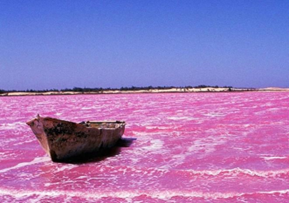
● Lake Retba, better known as Lac Rose (the Pink Lake), is located around 35km from the city of Dakar, Senegal. It sits in a depression with a shoreline 6.5 metres below sea level.
● The lake’s waters are virtually devoid of life, with the exception of a few microscopic algae and bacteria.
● It’s losing its appeal for a number of reasons. Apart from tourism, artisanal salt mining has been one of the dominant activities around the lake.
Why does the water turn pink?
● The pink coloration is due to the proliferation of halophilic green algae (living in a salty environment), Dunaliella salina, which contain red pigments. The alga is associated with halophilic bacteria of the genus Halobacterium. This microscopic alga’s resistance to salt comes from its high concentration of carotenoid pigments, which protect it from light, and its high glycerol content.
● In fact, Dunaliella salina contains at least four antioxidant pigments (beta-carotene, astaxanthin, lutein and zeaxanthin), which are rich in vitamins and trace elements. When salinity is high, algae with red pigments thrive, and when salinity is low, they give way to other algae rich in green pigments.
Pair 2 is matched incorrectly:
● Wildlife conservation organisation World Wildlife Fund (WWF) has urged the Romanian government to classify Mahmudia wetland as a ‘national interest ecological restoration area’ to protect its natural progress and foster community prosperity.
● The Mahmudia wetland is situated in Romania’s Danube Delta.
● It is facing a critical threat as agricultural leaseholders seek to revert a significant portion of the naturally restored wetlands to cropland.
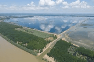
● This move poses a risk to the biodiversity, livelihoods, and climate resilience that the wetland currently provides.
Pair 3 is matched incorrectly:
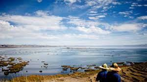
● Lake Titicaca is facing a serious threat from climate change and drought.
● It is the largest freshwater lake in South America and the highest of the world’s largest lakes.
● The lake, which lies on the border between Bolivia and Peru, has seen its water levels drop to near-record lows.
● The lack of rainfall and the increased evaporation due to rising temperatures have reduced the inflow and volume of the lake.
● This has resulted in stranded boats, exposed shorelines, and diminished fish populations.
● The lake is also home to more than 500 species of plants and animals, some of which are endemic and endangered.
 Incorrect
Answer: A
Explanation:
Pair 1 is matched correctly:
● Lake Retba, better known as Lac Rose (the Pink Lake), is located around 35km from the city of Dakar, Senegal. It sits in a depression with a shoreline 6.5 metres below sea level.
● The lake’s waters are virtually devoid of life, with the exception of a few microscopic algae and bacteria.
● It’s losing its appeal for a number of reasons. Apart from tourism, artisanal salt mining has been one of the dominant activities around the lake.
Why does the water turn pink?
● The pink coloration is due to the proliferation of halophilic green algae (living in a salty environment), Dunaliella salina, which contain red pigments. The alga is associated with halophilic bacteria of the genus Halobacterium. This microscopic alga’s resistance to salt comes from its high concentration of carotenoid pigments, which protect it from light, and its high glycerol content.
● In fact, Dunaliella salina contains at least four antioxidant pigments (beta-carotene, astaxanthin, lutein and zeaxanthin), which are rich in vitamins and trace elements. When salinity is high, algae with red pigments thrive, and when salinity is low, they give way to other algae rich in green pigments.
Pair 2 is matched incorrectly:
● Wildlife conservation organisation World Wildlife Fund (WWF) has urged the Romanian government to classify Mahmudia wetland as a ‘national interest ecological restoration area’ to protect its natural progress and foster community prosperity.
● The Mahmudia wetland is situated in Romania’s Danube Delta.
● It is facing a critical threat as agricultural leaseholders seek to revert a significant portion of the naturally restored wetlands to cropland.
● This move poses a risk to the biodiversity, livelihoods, and climate resilience that the wetland currently provides.
Pair 3 is matched incorrectly:
● Lake Titicaca is facing a serious threat from climate change and drought.
● It is the largest freshwater lake in South America and the highest of the world’s largest lakes.
● The lake, which lies on the border between Bolivia and Peru, has seen its water levels drop to near-record lows.
● The lack of rainfall and the increased evaporation due to rising temperatures have reduced the inflow and volume of the lake.
● This has resulted in stranded boats, exposed shorelines, and diminished fish populations.
● The lake is also home to more than 500 species of plants and animals, some of which are endemic and endangered.
-
Question 2 of 5
2. Question
2. Consider the following statements regarding the rivers originating from Hindu Kush Himalayan (HKH) region:
1. The Amu Darya River flows into the Aral Sea.
2. The Tarim River flows into the Taklamakan Desert.
3. The Yellow River flows into the Gulf of Bohai.
4. The Mekong River flows into the Gulf of Thailand.
How many of the above statements are correct?Correct
Answer: C
Explanation:
Statement 1 is correct:
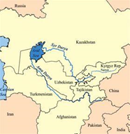
● The Amu Darya, historically known as the Oxus River, is a major river in Central Asia and Afghanistan.
● Rising in the Pamir Mountains, north of the Hindu Kush, the Amu Darya is formed by the confluence of the Vakhsh and Panj rivers, in the Tigrovaya Balka Nature Reserve on the border between Afghanistan and Tajikistan, and flows from there north-westwards into the southern remnants of the Aral Sea.
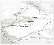
Statement 2 is correct:
● The Tarim River is a river in Xinjiang, China.
● It is the longest inland river in China.
● It is the principal river of the Tarim Basin, a desert region of Central Asia between the Tian Shan and Kunlun Mountains.
● The river historically terminated at Lop Nur, but today reaches no further than Taitema Lake before drying out in Taklamakan Desert.
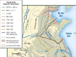
Statement 3 is correct:
● The Yellow River (Huang He) is the second longest river in China (after the Yangtze).
● It’s the fifth-longest river in the world.
● Source: The Bayankala Mountains on the Plateau of Tibet in western central China.
● Mouth: Southern Bohai Sea
● Claims to fame: world’s muddiest major river, “China’s cradle (of civilization)”
● The name “Yellow River” comes from the huge amounts of “yellow” loess sediment it carries, which are eroded when it flows through the Loess Plateau.
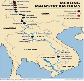
Statement 4 is incorrect:
● The Mekong River is a trans-boundary river in East Asia and Southeast Asia.
● It is the world’s twelfth-longest river and the third-longest in Asia with an estimated length of 4,909 km.
● From its headwaters in the Tibetan Plateau, the river runs through Southwest China (where it is officially called the Lancang River), Myanmar, Laos, Thailand, Cambodia, and southern Vietnam.
● Even so, the river is a major trade route between Tibet and Southeast Asia.
● Mouth of the river: South China Sea
 Incorrect
Answer: C
Explanation:
Statement 1 is correct:
● The Amu Darya, historically known as the Oxus River, is a major river in Central Asia and Afghanistan.
● Rising in the Pamir Mountains, north of the Hindu Kush, the Amu Darya is formed by the confluence of the Vakhsh and Panj rivers, in the Tigrovaya Balka Nature Reserve on the border between Afghanistan and Tajikistan, and flows from there north-westwards into the southern remnants of the Aral Sea.
Statement 2 is correct:
● The Tarim River is a river in Xinjiang, China.
● It is the longest inland river in China.
● It is the principal river of the Tarim Basin, a desert region of Central Asia between the Tian Shan and Kunlun Mountains.
● The river historically terminated at Lop Nur, but today reaches no further than Taitema Lake before drying out in Taklamakan Desert.
Statement 3 is correct:
● The Yellow River (Huang He) is the second longest river in China (after the Yangtze).
● It’s the fifth-longest river in the world.
● Source: The Bayankala Mountains on the Plateau of Tibet in western central China.
● Mouth: Southern Bohai Sea
● Claims to fame: world’s muddiest major river, “China’s cradle (of civilization)”
● The name “Yellow River” comes from the huge amounts of “yellow” loess sediment it carries, which are eroded when it flows through the Loess Plateau.
Statement 4 is incorrect:
● The Mekong River is a trans-boundary river in East Asia and Southeast Asia.
● It is the world’s twelfth-longest river and the third-longest in Asia with an estimated length of 4,909 km.
● From its headwaters in the Tibetan Plateau, the river runs through Southwest China (where it is officially called the Lancang River), Myanmar, Laos, Thailand, Cambodia, and southern Vietnam.
● Even so, the river is a major trade route between Tibet and Southeast Asia.
● Mouth of the river: South China Sea
-
Question 3 of 5
3. Question
3. Consider the following statements about traditional cultivation systems:
1. Akkadi Saalu is an intercropping system that has been in traditional practice in Kerala.
2. Khandagari is a traditional shifting cultivation system in North East India.
3. The Kuttanad farming system is the practice of rice cultivation below sea level in coastal Karnataka.
How many of the above statements are correct?Correct
Answer: D
Explanation:
Statement 1 is incorrect:
● AKKADI SAALU (Diversified Farming Systems) is a traditional culture of farming by growing diversified crops in a given plot under rain-fed conditions.
● This traditional cultivation practice is largely practiced in interior Karnataka.
● It is also connecting monsoon and rabi cropping seasons, where the rainfall is effectively utilized to secure varieties of food – fodder – fiber crops in a given land.
● Securing nutritional food security for soil microbes – plants – domestic animals and farming communities is the goal of AKKADI SAALU.
● AKKADI SAALU METHOD ensures one or the other crops above the soil for more than eight months in a year to conserve the soil moisture, enhance the nutrients status of soil, control the erosion losses, suppress the weeds in crop plants, and remove the residual effects of pesticides, fertilizers, and heavy metals from earlier use.
Statement 2 is incorrect:
Kandhagari traditional cultivation system:
● Wayanad is a place in Kerala which is characterized by its traditional shifting cultivation system called “Kandhagari”, which involves the rotation of crops like rice, millets and tubers.
● This system has helped maintain biodiversity and is deeply rooted in the culture of the indigenous communities.
Statement 3 is incorrect:
Kuttanad below sea level farming system:
● The only system in India that has been practicing rice cultivation below sea level since the past 2 centuries.
● Kuttanad is a delta region of about 900 sq. km situated on the west coast of Kerala State, India. The area is a larger mosaic of fragmented landscape patches and varied ecosystems such as coastal backwaters, rivers, vast stretches of paddy fields, marshes, ponds, garden lands, edges, corridors and remarkably networked waterways.
● The Kuttanad Below Sea-level Farming System (KBSFS) is unique, as it is the only system in India that practices rice cultivation below sea level. The major land use structure of KBSFS is flat stretches of rice fields in about 50,000 ha of mostly reclaimed delta swamps. The rice fields, which are popularly known as “Puncha Vayals’ ‘ exist in three landscape elements: Karapadam (upland rice fields), Kayal (wetland rice fields) and Kari (land buried with black coal-like materials).Incorrect
Answer: D
Explanation:
Statement 1 is incorrect:
● AKKADI SAALU (Diversified Farming Systems) is a traditional culture of farming by growing diversified crops in a given plot under rain-fed conditions.
● This traditional cultivation practice is largely practiced in interior Karnataka.
● It is also connecting monsoon and rabi cropping seasons, where the rainfall is effectively utilized to secure varieties of food – fodder – fiber crops in a given land.
● Securing nutritional food security for soil microbes – plants – domestic animals and farming communities is the goal of AKKADI SAALU.
● AKKADI SAALU METHOD ensures one or the other crops above the soil for more than eight months in a year to conserve the soil moisture, enhance the nutrients status of soil, control the erosion losses, suppress the weeds in crop plants, and remove the residual effects of pesticides, fertilizers, and heavy metals from earlier use.
Statement 2 is incorrect:
Kandhagari traditional cultivation system:
● Wayanad is a place in Kerala which is characterized by its traditional shifting cultivation system called “Kandhagari”, which involves the rotation of crops like rice, millets and tubers.
● This system has helped maintain biodiversity and is deeply rooted in the culture of the indigenous communities.
Statement 3 is incorrect:
Kuttanad below sea level farming system:
● The only system in India that has been practicing rice cultivation below sea level since the past 2 centuries.
● Kuttanad is a delta region of about 900 sq. km situated on the west coast of Kerala State, India. The area is a larger mosaic of fragmented landscape patches and varied ecosystems such as coastal backwaters, rivers, vast stretches of paddy fields, marshes, ponds, garden lands, edges, corridors and remarkably networked waterways.
● The Kuttanad Below Sea-level Farming System (KBSFS) is unique, as it is the only system in India that practices rice cultivation below sea level. The major land use structure of KBSFS is flat stretches of rice fields in about 50,000 ha of mostly reclaimed delta swamps. The rice fields, which are popularly known as “Puncha Vayals’ ‘ exist in three landscape elements: Karapadam (upland rice fields), Kayal (wetland rice fields) and Kari (land buried with black coal-like materials). -
Question 4 of 5
4. Question
4. Consider the following pairs:
Indian tribes in news – States
1. Hakki Pikki tribes – Karnataka
2. Hattee tribes – Himachal Pradesh
3. Soligas tribes – Meghalaya
How many of the above pairs are correctly matched?Correct
Answer: B
Explanation:
Pair 1 is matched correctly:
● The Hakki Pikkis are traditionally a semi-nomadic tribe of bird catchers and hunters, who settled down in several parts of Karnataka.
● In the last 20 years the community left bird catching and hunting, and have started to prepare traditional medicines, especially hair oils.
● Their settlement is mainly on the edge of Bannerghatta National Park.
Pair 2 is matched correctly:
● Recently, the Central Government granted Tribal Status to the Hatti Community of the Tans-Giri region of Himachal Pradesh’s Sirmaur district.
Who are the Hattis?
● The Hattis are a close-knit community that got their name from their tradition of selling homegrown vegetables, crops, meat, and wool, etc. at small markets called ‘haat’ in towns.
● Hatti men traditionally don a distinctive white headgear on ceremonial occasions.
Pair 3 is matched incorrectly:
● Indigenous groups Soligas have been living in the Cauvery Basin and the surrounding hills of peninsular India for thousands of years.
● Soligas, one of the oldest indigenous communities in the country, are the original inhabitants of Karnataka and live mostly in the Chamarajanagar and Mandya districts.
● Honey is an important part of the diet for the Soliga people, who still forage large parts of their food from the biodiversity-rich Ghats.
● They are the first tribal community living inside the core area of a tiger reserve in India to get their forest rights officially recognised by a court of law.
● Also the scientific community has named a new genus (Soliga ecarinata) of wasp after this community.Incorrect
Answer: B
Explanation:
Pair 1 is matched correctly:
● The Hakki Pikkis are traditionally a semi-nomadic tribe of bird catchers and hunters, who settled down in several parts of Karnataka.
● In the last 20 years the community left bird catching and hunting, and have started to prepare traditional medicines, especially hair oils.
● Their settlement is mainly on the edge of Bannerghatta National Park.
Pair 2 is matched correctly:
● Recently, the Central Government granted Tribal Status to the Hatti Community of the Tans-Giri region of Himachal Pradesh’s Sirmaur district.
Who are the Hattis?
● The Hattis are a close-knit community that got their name from their tradition of selling homegrown vegetables, crops, meat, and wool, etc. at small markets called ‘haat’ in towns.
● Hatti men traditionally don a distinctive white headgear on ceremonial occasions.
Pair 3 is matched incorrectly:
● Indigenous groups Soligas have been living in the Cauvery Basin and the surrounding hills of peninsular India for thousands of years.
● Soligas, one of the oldest indigenous communities in the country, are the original inhabitants of Karnataka and live mostly in the Chamarajanagar and Mandya districts.
● Honey is an important part of the diet for the Soliga people, who still forage large parts of their food from the biodiversity-rich Ghats.
● They are the first tribal community living inside the core area of a tiger reserve in India to get their forest rights officially recognised by a court of law.
● Also the scientific community has named a new genus (Soliga ecarinata) of wasp after this community. -
Question 5 of 5
5. Question
5. Consider the following rocks:
1. Gabbro
2. Shale
3. Phyllite
4. Marble
5. Granite
6. Diorite
How many of the above rocks are ‘Igneous rocks’?Correct
Answer: A
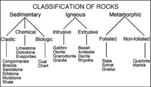
Explanation: Gabbro, Granite and Diorite are the igneous rocks here.
Igneous rocks:
● Igneous rocks are classified based on texture. Texture depends upon size and arrangement of grains or other physical conditions of the materials. If molten material is cooled slowly at great depths, mineral grains may be very large.
● Sudden cooling (at the surface) results in small and smooth grains.
● Intermediate conditions of cooling would result in intermediate sizes of grains making up igneous rocks.
● Granite, gabbro, pegmatite, basalt, volcanic breccia and tuff are some of the examples of igneous rocks.
Additional Information
Other types of rocks are:
Sedimentary Rocks –
● The word ‘sedimentary’ is derived from the Latin word ‘sedimentum’, which means settling.
● Rocks (igneous, sedimentary and metamorphic) of the earth’s surface are exposed to denudational agents, and are broken up into various sizes of fragments. Such fragments are transported by different exogenous agencies and deposited. These deposits through compaction turn into rocks. This process is called lithification. In many sedimentary rocks, the layers of deposits retain their characteristics even after lithification.
● Depending upon the mode of formation, sedimentary rocks are classified into three major groups:
✔ Mechanically formed — sandstone, conglomerate, limestone, shale, loess etc.
✔ Organically formed — geyserite, chalk, limestone, coal etc.
✔ Chemically formed — chert, limestone, halite, potash etc.
Metamorphic Rocks:
● The word metamorphic means ‘change of form’. These rocks form under the action of pressure, volume and temperature (PVT) changes.
● Metamorphism occurs when rocks are forced down to lower levels by tectonic processes or when molten magma rising through the crust comes in contact with the crustal rocks or the underlying rocks are subjected to great amounts of pressure by overlying rocks. Metamorphism is a process by which already consolidated rocks undergo recrystallisation and reorganisation of materials within original rocks.
● Types of metamorphic rocks depend upon original rocks that were subjected to metamorphism.
● Metamorphic rocks are classified into two major groups — foliated rocks and non-foliated rocks.
✔ Gneissoid, syenite, slate, schist, marble, quartzite etc. are some examples of metamorphic rocks.
 Incorrect
Answer: A
Explanation: Gabbro, Granite and Diorite are the igneous rocks here.
Igneous rocks:
● Igneous rocks are classified based on texture. Texture depends upon size and arrangement of grains or other physical conditions of the materials. If molten material is cooled slowly at great depths, mineral grains may be very large.
● Sudden cooling (at the surface) results in small and smooth grains.
● Intermediate conditions of cooling would result in intermediate sizes of grains making up igneous rocks.
● Granite, gabbro, pegmatite, basalt, volcanic breccia and tuff are some of the examples of igneous rocks.
Additional Information
Other types of rocks are:
Sedimentary Rocks –
● The word ‘sedimentary’ is derived from the Latin word ‘sedimentum’, which means settling.
● Rocks (igneous, sedimentary and metamorphic) of the earth’s surface are exposed to denudational agents, and are broken up into various sizes of fragments. Such fragments are transported by different exogenous agencies and deposited. These deposits through compaction turn into rocks. This process is called lithification. In many sedimentary rocks, the layers of deposits retain their characteristics even after lithification.
● Depending upon the mode of formation, sedimentary rocks are classified into three major groups:
✔ Mechanically formed — sandstone, conglomerate, limestone, shale, loess etc.
✔ Organically formed — geyserite, chalk, limestone, coal etc.
✔ Chemically formed — chert, limestone, halite, potash etc.
Metamorphic Rocks:
● The word metamorphic means ‘change of form’. These rocks form under the action of pressure, volume and temperature (PVT) changes.
● Metamorphism occurs when rocks are forced down to lower levels by tectonic processes or when molten magma rising through the crust comes in contact with the crustal rocks or the underlying rocks are subjected to great amounts of pressure by overlying rocks. Metamorphism is a process by which already consolidated rocks undergo recrystallisation and reorganisation of materials within original rocks.
● Types of metamorphic rocks depend upon original rocks that were subjected to metamorphism.
● Metamorphic rocks are classified into two major groups — foliated rocks and non-foliated rocks.
✔ Gneissoid, syenite, slate, schist, marble, quartzite etc. are some examples of metamorphic rocks.